
Die Somerset Levels sind eine Küstenebene und ein Gebiet von Feuchtgebieten in Somerset, England, zwischen den Mendips im Süden und den Blackdown Hills.
Die Somerset Levels umfassen ein Gebiet von ca. 160000 acre|km2 and are bisected by the Polden Hills; the areas to the south are drained by the River Parrett, and the areas to the north by the rivers Axe and Brue. The Mendip Hills separate the Somerset Levels from the North Somerset Levels. The Somerset Levels consist of marine clay "levels" along the coast and inland peat-based "moors"; agriculturally, about 70 per cent is used as grassland and the rest is arable. Willow and teazel are grown commercially and peat is extracted.
A Palaeolithic flint tool found in West Sedgemoor is the earliest indication of human presence in the area. The Neolithic people exploited the reed swamps for their natural resources and started to construct wooden trackways, including the world's oldest known timber trackway, the Post Track, dating from about 3800 BC. The Levels were the location of the Glastonbury Lake Village as well as two Lake villages at Meare Lake. Several settlements and hill forts were built on the natural "islands" of slightly raised land, including Brent Knoll and Glastonbury. In the Roman period sea salt was extracted and a string of settlements were set up along the Polden Hills. The discovery at Shapwick of 9,238 silver Roman coins, known as the Shapwick Hoard, was the second largest ever found from the time of the Roman Empire. A number of Saxon charters document the incorporation of areas of moor in estates. In 1685, the Battle of Sedgemoor was fought in the Bussex area of Westonzoyland at the conclusion of the Monmouth Rebellion.
As a result of the wetland nature of the Levels, the area contains a rich biodiversity of national and international importance. It supports a vast variety of plant and bird species and is an important feeding ground for birds and includes 32 Sites of Special Scientific Interest, of which 12 are also Special Protection Areas. The area has been extensively studied for its biodiversity and heritage, and has a growing tourism industry.
People have been draining the area since before the Domesday Book. In the Middle Ages, the monasteries of Glastonbury, Athelney and Muchelney were responsible for much of the drainage. The artificial Huntspill River was constructed during the Second World War as a reservoir, although it also serves as a drainage channel. The Sowy River between the River Parrett and King's Sedgemoor Drain was completed in 1972; water levels are managed by the Levels internal drainage boards. During 2009 and 2010 proposals to build a series of electricity pylons by one of two routes between Hinkley Point and Avonmouth, to transmit electricity from the proposed Hinkley Point C nuclear power station, attracted local opposition. Discussions have taken place concerning the possibility of obtaining World Heritage Site status for the Somerset Levels as a "cultural landscape".[1] It was suggested that if this bid were successful it could improve flood control, but only if wetland fens were created again; the plans were abandoned in 2010.[2]
Natural character area
BearbeitenThe Somerset Levels form a natural region that has been designated as a national character area – No. 142 – by Natural England, the public body responsible for England's natural environment. Neighbouring natural regions are: the Vale of Taunton and Quantock Fringes to the west, the Blackdowns to the southwest, the Mid Somerset Hills and Yeovil Scarplands to the southeast, the Mendip Hills to the east and the Bristol, Avon Valleys and Ridges to the northeast.[3][4][5]
Geography
Bearbeiten
The Levels are mainly flat areas of inland plains and a coastal sand and clay barrier, east and west of the M5 motorway. There are some slightly raised parts, called "burtles",[6] as well as higher ridges and hills. The Levels are about Vorlage:Convert above mean sea level (O.D.). The general elevation inland is Vorlage:Convert O.D. with peak tides of Vorlage:Convert O.D. recorded at Bridgwater and Burnham-on-Sea.[7] Large areas of peat were laid down in the Brue Valley during the Quaternary period after the ice sheets melted.[6] The area's topography consists of two basins mainly surrounded by hills, the runoff from which forms rivers that originally meandered across the plain but have now been controlled by embanking and clyses (the local name for a sluice).[8] The area is prone to winter floods of fresh water and occasional salt water inundations. The worst in recorded history was the Bristol Channel floods of 1607, which resulted in the drowning of an estimated 2,000 or more people, houses and villages swept away, an estimated Vorlage:Convert of farmland inundated, and livestock killed.[9] Another severe flood occurred in 1872–1873, when over Vorlage:Convert were underwater from October to March.[10]
Although underlain by much older Triassic age[6][11] formations that protrude to form what would once have been islands—such as Athelney, Brent Knoll, Burrow Mump and Glastonbury Tor—the lowland landscape was formed only during the last 10,000 years, following the end of the last ice age. Glastonbury Tor is composed of Upper Lias Sand. The Poldens and the Isle of Wedmore are composed of Blue Lias and Marl, while the Mendips are largely Carboniferous limestone.[12] Although sea level changes since the Pliocene led to changes in sea level and the laying down of vegetation,[13] the peak of the peat formation took place in swamp conditions around 6,000 years ago, although in some areas it continued into medieval times.[14][15]
It is a mainly agricultural region, typically with open fields of permanent grass surrounded by ditches with willow trees. Access to individual areas, especially for cattle, was provided by means of "droves", i.e. green lanes, leading off the public highways. Some of the old roads, in contrast to the old hollow ways found in other areas of England, are causeways raised above the level of the surrounding land, with a drainage ditch running along each side.[16]
Settlements
BearbeitenVorlage:Location map+ Most of the settlements on the Levels are small villages. In the south, Aller, which has a population of 374,[17] includes the hamlet of Beer (sometimes Bere) and the deserted medieval village of Oath on the opposite bank of the River Parrett. The area known as the Isle of Athelney was once a very low isolated island linked by a causeway to East Lyng, each end of which was protected by a semi-circular stockade and ditch. The ditch on the island is now known to date from the Iron Age, and was used by Alfred the Great as a fort before the Battle of Ethandun in May 878; in gratitude for his victory Alfred founded a monastery, Athelney Abbey,[18] on the Isle in 888, which survived until the Dissolution of the Monasteries under Henry VIII in 1539. Bawdrip is a small village which has a population of 498.[19] Brent Knoll is a large village at the foot of Vorlage:Convert Brent Knoll Camp that dominates the surrounding landscape; the name means Beacon Hill in Old English.[20] Brent Knoll has been inhabited since at least the Bronze Age.[21] Before the Somerset Levels were drained, Brent Knoll was an island known as the Isle (or Mount) of Frogs.[22]
Glastonbury (population 8,784)[23] and Street (11,066)[23] lie on opposite sides of the River Brue, and provide a central point for trade and commerce. Larger centres are generally on slightly higher ground around the edges of the Levels. Bridgwater is a market town, the administrative centre of the Sedgemoor district, and a major industrial centre. With a population of 33,698,[19] it straddles the major communication routes through South West England. Situated on the edge of the Somerset Levels, along both banks of the River Parrett and Vorlage:Convert from its mouth, it was at one time a major port and trading centre. The hamlet of Dunball forms part of the port on the river. Burrowbridge lies on the River Parrett further inland. The name probably comes from the Old English buruh (fortified hill) and bryċġ (bridge).[24] In the village is Burrow Mump, an ancient earthwork now owned by the National Trust. Burrow Mump is also known as St Michael's Borough or Tutteyate.[25] It is a natural hill of Triassic sandstone capped by Keuper marl.[26] Excavations showed evidence of a medieval masonry building on the top of the hill.[27]
Along the coast, settlements such as Berrow are built on the line of sand dunes separating the low-lying marshes from the Bristol Channel. At the northern end Bleadon lies on the River Axe; and there was for many years a small harbour, sometimes known as Lympsham Wharf.[28] The arrival of the Bristol and Exeter Railway in 1841, which crossed the Axe on a bridge, obstructed river traffic beyond the wharf, making it the limit of navigation for coastal vessels.[28] An Act of 1915 authorised the drainage of the river and installation of a flood gate at Bleadon,[29] although attempts to control the water had occurred on Bleadon Level since medieval times, including an early windmill, in 1613, to pump water into the sea from behind a sea wall.[30] Burnham-on-Sea (population 18,401)[31] is at the mouth of the River Parrett where it enters Bridgwater Bay.[32] The position of the town on the edge of the Somerset Levels has resulted in a history dominated by land reclamation and sea defences since Roman times.[33] Burnham was seriously affected by the Bristol Channel floods of 1607, and various flood defences have been installed since then.[34] A concrete sea wall was built in 1911, and after the Second World War further additions to the defences were made, using the remains of a Mulberry harbour; the present curved concrete wall was completed in 1988.[35] Highbridge, which neighbours Burnham, is near the mouth of the River Brue and the villages of East and West Huntspill.[32]
Climate
BearbeitenAlong with the rest of South West England the Somerset Levels have a temperate climate, which is generally wetter and milder than the rest of the country.[36] The annual mean temperature is approximately Vorlage:Convert. Seasonal temperature variation is less extreme than most of the United Kingdom because of the adjacent sea. The summer months of July and August are the warmest, with mean daily maxima of approximately Vorlage:Convert. In winter, mean minimum temperatures of Vorlage:Convert are common.[36] The Azores high pressure area influences the southwest of England's summer weather, but convective cloud sometimes forms inland, reducing the number of hours of sunshine. Annual sunshine rates are slightly less than the regional average of 1,600 hours.[36] In December 1998, there were 20 days without sun recorded at Yeovilton. Most rainfall in the southwest is caused by convection or Atlantic depressions, which are most active in autumn and winter, when they are the chief cause of rain. In summer, a large proportion of the rainfall is caused by the Sun heating the land, leading to convection and to showers and thunderstorms. Average rainfall is around Vorlage:Convert, and about 8–15 days of snowfall is typical. November to March have the highest mean wind speeds, and June to August have the lightest winds. The predominant wind direction is from the southwest.[36] It was devastated by the UK storms of January–February 2014.
Water management
Bearbeiten
The Moors and Levels, formed from a submerged and reclaimed landscape, consist of a coastal clay belt only slightly above mean sea level, with an inland peat belt at a lower level behind it.[37]
Early attempts to control the water levels were possibly made by the Romans (although records only date from the 13th century), but were not widespread.[38]
There was a port at Bleadney on the River Axe in the 8th century which allowed goods to be brought to within Vorlage:Convert of Wells. In 1200, a wharf was constructed at Rackley near Axbridge. The Parrett was navigable up as far as Langport in 1600, with 15 to 20 ton barges. The Domesday Book recorded that drainage of the higher grounds was under way, although the moors at Wedmoor were said to be useless.[39]
In the Middle Ages, the monasteries of Glastonbury, Athelney, and Muchelney were responsible for much of the drainage. In 1129, the Abbot of Glastonbury was recorded as inspecting enclosed land at Lympsham. Efforts to control flooding on the Parrett were recorded around the same date. In 1234, Vorlage:Convert were reclaimed near Westonzoyland and, from the accounts in the abbey's rent books, this had increased to Vorlage:Convert by 1240.[40]
Drains
Bearbeiten
Flooding of adjacent moor land was partially addressed during the 13th century by the construction of a number of embankment walls to contain the Parrett. They included Southlake Wall, Burrow Wall, and Lake Wall.[41] The River Tone was also diverted by the Abbot of Athelney and other land owners into a new embanked channel, joining the Parrett upstream from its original confluence.[42]
The main drainage outlets flowing through the Moors and Levels are the rivers Axe, Brue, Huntspill, Parrett, Tone, and Yeo, together with the King's Sedgemoor Drain, an artificial channel into which the River Cary now runs. Previously, the Cary ran into the Tone while the Brue ran through Meare Pool (now drained) and the Panborough Gap, and then into the Axe. Another accomplishment in the Middle Ages was the construction of the tidal Pillrow Cut, joining the Brue and Axe.
In 1500, there was said to be Vorlage:Convert of floodable land of which only Vorlage:Convert had been reclaimed. In 1597, Vorlage:Convert of land were recovered near the Parrett estuary; a few years later, Vorlage:Convert near Pawlett were recovered by means of embankments; and three further reclamations, totalling Vorlage:Convert, had been undertaken downstream of Bridgwater by 1660.[43]
In the early 17th century, during the time of King James I, abortive plans were made to drain and enclose much of Sedgemoor, which the local Lords supported but opposed by the Commoners who would have lost grazing rights.[44] In 1632, Charles I sold the Crown's interest in the scheme, and it was taken over by a consortium that included Sir Cornelius Vermuyden, a Dutch drainage engineer. However, the work was delayed by the English Civil War and later defeated in parliament after local opposition.[10] In 1638, it was reported that nearly Vorlage:Convert of Tealham and Tadham Moors were not reclaimed, with a total of Vorlage:Convert being undrained. Between 1785 and 1791, much of the lowest part of the peat moors was enclosed. In 1795, John Billingsley advocated enclosure and the digging of rhynes (a local name for drainage channels, pronounced "reens" in the east and rhyne to the west) between plots,[45] and wrote in his Agriculture of the County of Somerset that Vorlage:Convert had been enclosed in the last 20 years in Wedmore and Meare, Vorlage:Convert at Nyland, Vorlage:Convert at Blackford, Vorlage:Convert at Mark, Vorlage:Convert in Shapwick, and Vorlage:Convert at Westhay.[46]
At Westhay Moor in the early 19th century, it was shown how peat bogs could be successfully drained and top-dressed with silt deposited via flooding, creating a very rich soil.[47] The character of the soil was also changed by the spreading of clay and silt from the digging of King's Sedgemoor Drain.[48]
Pumps
Bearbeiten
Little attempt was made during the 17th and 18th centuries to pump water, possibly because the coal-driven Newcomen steam engines would have been uneconomical. It is unclear why windmills were not employed, as they were on the Fens of East Anglia, but only two examples have been recorded on the Levels: one at Bleadon at the mouth of the River Axe, where a sea wall had been built, and the other at Common Moor north of Glastonbury, which was being drained following a private Act of Parliament in 1721.[10] The first steam pumping station was Westonzoyland Pumping Station in 1830, followed by more effective ones from 1860. Automatic electric pumps are used today.[49]
The man-made Huntspill River was constructed during World War II with sluices at both ends to provide a guaranteed daily supply of Vorlage:Convert of "process water".[50] It was intended that in the summer, when water supply was lower, it would serve as a reservoir with water pumped from the moors; and in winter serve as a drainage channel, via gravity drainage.[50][51] Geotechnical problems prevented it from being dug as deep as originally intended and so gravity-drainage of the moors was not possible: thus, water is pumped up into the river throughout the year.[50]
The Sowy River between the River Parrett and King's Sedgemoor Drain was completed in 1972.[52][53] The Levels and Moors are now artificially drained by a network of rhynes which are pumped up into "drains". Water levels are managed by the Levels internal drainage boards (IDBs); the Levels are not as intensively drained or farmed as the East Anglian fens, historically a similar area of low marsh. They are still liable to widespread fresh water flooding in winter. One of the approaches to reducing the risk of flooding within the catchment area of the Parrett is the planting of new woodlands.[54]
Controversy about the management of the drainage and flood protection has previously involved the activities of IDBs.[55][56] However, IDBs have been actively participating with the Parrett Catchment Partnership, a partnership of 30 organisations that aims to create a consensus on how water is to be managed, in particular, looking at new ways to achieve sustainable benefits for all local stakeholders.[57]
During 2009 and 2010, work was undertaken to upgrade sluice gates, watercourses, and culverts to enable seasonal flooding of Southlake Moor during the winter diverting water from the Sowy River onto the moor. It has the capacity to hold 1.2 million cubic metres as part of a scheme by the Parrett Internal Drainage Board to restore ten floodplains in Somerset. In spring, the water is drained away to enable the land to be used as pasture during the summer.[58] The scheme is also used to encourage water birds.[59]
Sea defences
Bearbeiten
The Levels were frequently flooded by the sea during high tides, a problem that was not resolved until the sea defences were enhanced in the early 20th century. In addition, the problems of high fresh water floods are aggravated by the unrestricted entry of the tide along the Parrett,[60] which is the only river in the Levels and Moors that does not have a clyse on it. Discussions on whether a clyse is needed for the Parrett and whether it should be sited at Bridgwater or nearer the mouth of the river date back to 1939, at the start of World War II, and have not been resolved.[60]
On 13 December 1981, a large storm hit the North Somerset coast.[61] Meteorological conditions caused a large rising surge in sea level in the Bristol Channel, and wind was measured at Vorlage:Convert. Over topping of the sea defences along a Vorlage:Convert stretch of the Somerset coast at 22 locations from Clevedon to Porlock began after 19:30. Although there was no loss of life, the resultant flooding covered Vorlage:Convert of land, affecting 1,072 houses and commercial properties, with £150,000 worth of livestock killed and £50,000 of feed and grain destroyed. Wessex Water Authority estimated the total cost of the damage caused at £6M. This resulted in a three-year programme of sea defence assessment, repair and improvement.[61] With 400 properties affected in Burnham-on-Sea, after emergency repairs, Wessex Water Authority began planning new sea defences. Construction work started in 1983 on a £7M scheme, creating what was then Britain's biggest wave return wall.[61]
The Environment Agency's current "Parrett Catchment Flood Management Plan", published in December 2009, divides the Parrett catchment area into eight sub-areas, with the Somerset Levels and Moors falling into sub-area 6 and Bridgwater falling into sub-area 7.[62] As part of the published flood risk assessments for both these sub-areas, it is recognised that: at a future date a tidal clyse may be needed on the Parrett; this causes a funding dilemma; and, geomorphology studies of the Parrett and the Tone are needed to help address many of the uncertainties associated with a tidal exclusion project.[62]
Flooding
Bearbeiten
The Levels are at risk from both tidal and land-based flood waters.[37]
During the great storm of 1703, waves came four feet (1.2 m) over the sea walls. The sea wall was again breached in 1799, filling the Axe valley with sea water. In 1872, another flood covered Vorlage:Convert and in 1919, Vorlage:Convert were inundated with sea water, poisoning the land for up to 7 years.[63]
Since 1990, the drainage boards have been charged with watching the rhynes and keeping them clear, under the overall responsibility of the Environment Agency. With rising sea levels, the work required to maintain the sea defences is likely to become more expensive, and it has been proposed that two inland seas be created.[64] Other studies have recommended maintaining the current defences for five years while undertaking further studies of available options.[65]
Although the Environment Agency have made plans for the regular winter flooding, still in recent years this has resulted in a number of villages — including Langport, Muchelney and Westonzoyland — being cut off. In November 2012, during the 2012 Great Britain and Ireland floods, after six days Somerset County Council-funded BARB rescue boats reached Muchelney on 29 November, rescuing nearly 100 people.[66]
Rescue boats were again required during the rain and storms from Cyclone Dirk in the turn of the year 2014,[67] and subsequently during the Winter flooding of 2013–14 on the Somerset Levels. On 24 January 2014, in light of the continued flooded extent of the Somerset Moors and forecast new rainfall as part of the Winter storms of 2013–14 in the United Kingdom, both Somerset County Council and Sedgemoor District Council declared a major incident.[68][69] At this time, with Vorlage:Convert of agricultural land having been under water for over a month,[69] the village of Thorney had been abandoned and Muchelney had been cut off by flood waters for almost a month.[68] Environment Minister Owen Paterson visited the area on 27 January 2014, and after meeting local MPs, the Environment Agency and various community representatives the night before in Taunton, promised at a media-only press conference at North Moor pumping station that if a local water management plan could be developed over the next six weeks, he would approve it. Such plan would likely include the dredging of the rivers Tone and Parrett, and possibly a later sluice near Bridgwater.[70] There have been public protests about the river Parrett not being dredged in recent years. In mid-February 2014 the Environment Agency began installing giant pumps imported from the Netherlands to alleviate the continuing flooding.[71] Vorlage:Clear
Human habitation
Bearbeiten
A Palaeolithic flint tool found in Westbury is the earliest indication of human presence in the area, dating from approximately 500,000 years ago.[72] Later during the 7th millennium BC the sea level rose and flooded the valleys, forcing the Mesolithic people to occupy seasonal camps on the higher ground, indicated by scatters of flints.[73] Subsequent winter flooding probably led to prehistoric man's using the Levels only in the summer, hence the county of Somerset may derive its name from Sumorsaete, meaning land of the summer people. An alternative suggestion is that the name derives from Seo-mere-saetan meaning "settlers by the sea lakes".[74] The Neolithic people continued to exploit the reedswamps for their natural resources and started to construct wooden trackways such as the Sweet and Post Tracks. The Sweet Track, named after the peat digger who discovered it in 1970 and dating from the 3800s BC, is the world's oldest timber trackway, once thought to be the world's oldest engineered roadway.[75] The track was built between what was in the early 4th millennium BC an island at Westhay and a ridge of high ground at Shapwick, close to the River Brue. The remains of similar tracks have been uncovered nearby, connecting settlements on the peat bog including the Honeygore, Abbotts Way, Bells, Bakers, Westhay and Nidons trackways.[11]
The Levels contain the best-preserved prehistoric village in the UK,[76] Glastonbury Lake Village, as well as two others at Meare Lake Village.[77] Discovered in 1892 by Arthur Bulleid,[78] it was inhabited by about 200 people living in 14 roundhouses,[76] and was built on a morass on an artificial foundation of timber filled with brushwood, bracken, rubble and clay.[79] Investigation of the Meare Pool indicates that it was formed by the encroachment of raised peat bogs, particularly during the Subatlantic climatic period (1st millennium BC), and core sampling demonstrates that it is filled with at least Vorlage:Convert of detritus mud.[80][81]
The two villages within Meare Pool appear to originate from a collection of structures erected on the surface of the dried peat, such as tents, windbreaks and animal folds. Clay was later spread over the peat, providing raised stands for occupation, industry and movement, and in some areas thicker clay spreads accommodated hearths built of clay or stone.[82]
The area continued to be inhabited during the Bronze Age, when the population supported itself largely by hunting and fishing in the surrounding marshes, living on artificial islands connected by wooden causeways on wooden piles. There have been many finds of metalwork during peat cutting, which may have been devotional offerings. Brent Knoll has been settled by people since at least the Bronze Age. It is the site of an Iron Age hill fort known as Brent Knoll Camp, with multiple ramparts (multivallate) following the contours of the hill.[83] Several settlements and hill forts were built on the natural "islands" of slightly raised land, including Brent Knoll, Glastonbury, and the low range of the Polden Hills. According to legend Ider son of Nuth, who was one of King Arthur's knights, went to the Mount of Frogs on a quest to slay three giants who lived there.[84][85][86] The fort has been claimed as the site of the Battle of Mons Badonicus.[87]
_from_the_tor_arp.jpg)
Sea salt was extracted during the Roman period, and a string of settlements were set up along the Polden Hills. Some possible settlement sites are also known in the Draycott and Cheddar Moors and around Highbridge.[88] The discovery at Shapwick of 9,238 silver Roman coins,[89][90] the second largest hoard ever found from the Roman Empire included coins dated from as early as 31–30 BC up until 224 AD.[91] The hoard also contained two rare coins which had not been discovered in Britain before,[90] and the largest number of silver denarii ever found in Britain.[89][92]
A number of Anglo-Saxon charters document the incorporation of areas of moor in estates, suggesting that the area continued to be exploited.[93] It is easy to see why the area acquired a number of legends, particularly of King Arthur and his followers, who some believe based his court in the hill fort at South Cadbury.[94] According to legend, Alfred the Great burnt cakes when hiding in the marshes of Athelney, after the Danish invasion in 875. After the battle of Edington the Danish king was baptised at Aller and a peace treaty signed at Wedmore.[95]
In 1685, the Monmouth Rebellion ended at the Battle of Sedgemoor, which was fought in the Bussex area of Westonzoyland.[96]
Land use
BearbeitenThe Levels have few wooded areas, just occasional willow trees. The landscape is dominated by grassland, mostly used as pasture for dairy farming with approximately 70 per cent of the area being grassland and 30 per cent arable. From January until May, the River Parrett provides a source of European eels (Anguilla anguilla) and young elvers, which are caught by hand netting as this is the only legal means of catching them.[97] A series of eel passes have been built on the Parrett at the King's Sedgemoor Drain to help this endangered species; cameras have shown 10,000 eels migrating upstream in a single night.[98][99] The 2003 BBC Radio 4 play Glass Eels by Nell Leyshon was set on the Parrett.[100]
The Levels, as part of the West Country, traditionally produced cider, with individual farms having orchards and their own cider, known as scrumpy. However, over 60% of Somerset's orchards have been lost in the last fifty years;[101] and apple production occupies less than 0.4% of the land. Cider is still produced in Somerset by Thatchers Cider, Gaymer Cider Company and numerous small independent producers. Other local industries that once thrived on the Levels, such as thatching (using reeds) and basket making (using willow), have been in decline since the second half of the 20th century. Combined with the recent drop in farm incomes, this poses a potential threat to the "traditional" nature of the area as a whole. Subsidies are paid to farmers who manage their land in the traditional way.[102]
Electricity generation
BearbeitenIn 2009, National Grid began public consultations over plans to build a line of electricity pylons, by one of two routes between Hinkley Point and Avonmouth. The plans attracted local opposition.[103][104] The first consultation process ended in January 2010.[104] They had proposed that each pylon would be Vorlage:Convert high: the consultation was only in respect of preferences between two alternate routes, not the size nor the use of large pylons. The proposed line, which is due to open by September 2017, will transmit electricity at 400 kilovolts from the proposed Hinkley Point C nuclear power station.[104][105] Hinkley Point C is a project to construct a 3,200 MWe nuclear power station with two EPR reactors.[106] The site is one of eight announced by the British government in 2010,[107] and in November 2012 a nuclear site licence was granted.[108] On 28 July 2016 the EDF board approved the project,[109] and on 15 September 2016 the UK government approved the project with some safeguards for the investment.[110] In March 2017, EDF, after the Office for Nuclear Regulation gave approval to start building a network of tunnels to carry cabling and piping, started work also under way on a jetty, seawall and accommodation blocks.[111] The concrete pour for the first reactor is planned only at earliest in 2019.[112]
In 2010 and 2011, two proposals to build a total of 14 wind turbines, with Ecotricity to build five[113] or four[114] adjacent to the M5 Motorway near Brent Knoll and Électricité de France to build nine at East Huntspill,[105] are opposed by local groups on the grounds of their effect on the local environment and potential damage to the bird population.[115]
Willow
Bearbeiten
Willow has been cut and used on the Levels since mankind moved into the area. Fragments of willow basket were found near the Glastonbury Lake Village, and it was used in the construction of several Iron Age causeways.[116] The willow was harvested using traditional methods of pollarding, where a tree would be cut back to the main stem. New shoots of willow, called "withies", would grow out of the trunk and these would be cut periodically for use.[117]
During the 1930s, over Vorlage:Convert of willow were being grown commercially on the Levels. Largely because of the replacement of baskets by plastic bags and cardboard boxes, the industry has severely declined since the 1950s. By the end of the 20th century only about Vorlage:Convert were grown commercially, near the villages of Burrowbridge, Westonzoyland, and North Curry.[118] The Somerset Levels is now the only area in the UK where basket willow is grown commercially. For weaving, the species Salix triandra (almond willow, black maul) is grown, while Salix viminalis (common osier) is ideal for handles, bases, and the structural members in furniture and hurdles. Historically willow was used to make salmon traps or "putchers". Products including baskets, eel traps (kypes), lobster pots, and furniture were widely made from willow throughout the area in the recent past.[119] Among the more unusual products still made are passenger baskets for hot air balloons,[120] the frames inside the Bearskins worn by the regiments of the Grenadier Guards,[121] and an increasing number of willow coffins.[122]
Another use of willow has been found by the Coate family, who make artists' charcoals in Stoke St Gregory. It has become in 30 years the leading artists' charcoal manufacturer in Europe, producing most of the natural charcoals sold under different art-material brands.[123]
The industry is celebrated in the form of the Willow Man (sometimes known as the Angel of the South), a willow sculpture, 40 feet (12.2 m) tall, produced by artist Serena de la Hey in September 2000 that can be seen from the railway and the M5 motorway to the north of Bridgwater.[124] At Stoke St Gregory there is also a Willows and Wetlands Visitor Centre.[125]
Teazel growing
BearbeitenAn unusual crop is the growing of teazels around the River Isle near Chard on the heavy clay soils around Fivehead.[126] These are used to provide a fine finish on worsteds and snooker table cloths.[127]
Peat extraction
BearbeitenThe extraction of peat from the Moors is known to have taken place during Roman times, and has been carried out since the Levels were first drained.[128] The introduction of plastic packaging in the 1950s allowed the peat to be packed without rotting, which led to the industrialisation of peat extraction during the 1960s as a major market in horticultural peat was developed. The reduction in water levels that resulted put local ecosystems at risk; peat wastage in pasture fields was occurring at rates of 1–3 feet (0.3–0.8 m) over 100 years.[129] Peat extraction continues today, although much reduced.[6][130]
-
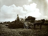
 Peat gatherers, Westhay, September 1905
 -
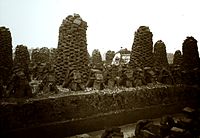 Peat stacks and cutting, Westhay, September 1905
 -
 Harvesting the peat, Westhay, September 1905


Biodiversity and conservation
Bearbeiten
As a result of their wetland nature, the Moors and Levels contain a rich biodiversity of national and international importance.[11] They support a vast variety of plant species, including common plants such as marsh marigold, meadowsweet, and ragged robin. The area is an important feeding ground for birds including Bewick's swan, Eurasian curlew, common redshank, Eurasian skylark, common snipe, Eurasian teal, wigeon, and Eurasian whimbrel, as well as birds of prey including the marsh harrier and peregrine falcon.[131] A wide range of insect species is also present, including rare invertebrates, particularly beetles including the lesser silver water beetle, Bagous nodulosus, Hydrophilus piceus, Odontomyia angulata, Oulema erichsoni, and Valvata macrostoma. In addition, the area supports an important otter population.[132] Water voles (Arvicola amphibius) are being encouraged to recolonise areas of the Levels where they have been absent for 10 years, by the capture of mink (Mustela vison).[133]
In 2010, a project was started to reintroduce the common crane to the Levels, after an absence of 400 years. The birds' eggs were flown from Germany to the Slimbridge wetland reserve managed by the Wildfowl and Wetlands Trust (a UK charity) at Slimbridge, Gloucestershire,[134] and reared to the age of five months before being released onto the Levels.[135] The "Great Crane Project" aims to introduce around 20 of the birds each year until 2015. The work, which included collaboration with Pensthorpe Nature Reserve and the Royal Society for the Protection of Birds, was supported by a grant of £700k from Viridor Credits.[136]
The Levels contain 32 Sites of Special Scientific Interest (12 of them also Special Protection Areas), the River Huntspill[137] and Bridgwater Bay national nature reserves,[138] the Somerset Levels and Moors Ramsar Site covering about Vorlage:Convert,[139] the Somerset Levels National Nature Reserve,[140] Shapwick Heath National Nature Reserve,[141] Ham Wall National Nature Reserve[142] and numerous Scheduled monuments. The Brue Valley Living Landscape conservation project commenced in 2009 and aims to restore, recreate and reconnect habitat. It aims to ensure that wildlife is enhanced and capable of sustaining itself in the face of climate change[143] while guaranteeing farmers and other landowners can continue to use their land profitably. It is one of an increasing number of landscape scale conservation projects in the UK.[144][145] About Vorlage:Convert of the Levels are recognised as an Environmentally Sensitive Area,[146] and other areas are designated as Areas of High Archaeological Potential, but there is currently no single conservation designation covering the Levels and Moors.[147]
A survey in 2005 discovered that 11 of the known wooden Bronze Age causeways on the Levels had been destroyed or vanished and others were seriously damaged, caused by the reduction in water levels and subsequent exposure of the timber to oxygen and aerobic bacteria.[148] Part of the Sweet Track is being actively conserved. Following purchase of land by the National Heritage Memorial Fund, and installation of a water pumping and distribution system along a Vorlage:Convert section, several hundred metres of the track's length are now being actively conserved.[149] This method of preserving wetland archaeological remains (i.e. maintaining a high water table and saturating the site) is rare.[150] A Vorlage:Convert section, which lies within the land owned by the Nature Conservancy Council, has been surrounded by a clay bank to prevent drainage into surrounding lower peat fields, and water levels are regularly monitored.[151] The viability of this method is demonstrated by comparing it with the nearby Abbot's Way, which has not had similar treatment, and which in 1996 was found to have become dewatered and desiccated.[152] Evaluation and maintenance of water levels in the Shapwick Heath Nature Reserve involves the Nature Conservancy Council, the Department for Environment, Food and Rural Affairs and the Somerset Levels Project.[153]
Somerset Levels Project
BearbeitenIn 1964, archaeologist John Coles from the University of Cambridge began a research project that resulted in the publication of an important series of papers on many aspects of the Levels. A range of archaeological projects, such as the exploration of various trackways from the 3rd and 1st millennia BC and the establishment of their economic and geographic significance, was funded by various donors including English Heritage.[154] Possibly the project's most significant excavation was of the Sweet Track in 1970,[155] during which a Jadeite axe was discovered.[156] Eight radiocarbon determinations of the date of the axe place it at around 3200 BC.[157]
The work of John Coles and the Somerset Levels Project was recognised in 1998 when they won the ICI Award for the best archaeological project offering a major contribution to knowledge,[158] and in 2006 with the award of the European Archaeological Heritage Prize.[159]
Shapwick Project
BearbeitenThis project, based on the village of Shapwick, was begun by Mick Aston of Bristol University to investigate the evolution of a typical English village.[160] A preliminary study of the village's history was carried out using maps and documents, then surveys of the buildings were made together with botanical surveys. Field walking was carried out and key sites excavated. A report on the project, which ran from 1989 to 1999, was published in eight volumes.[161]
Tourism
Bearbeiten
Being largely flat, the Levels are well suited to bicycles, and a number of cycle routes exist including the Withy Way Cycle Route (Vorlage:Convert), Avalon Marshes Cycle Route (Vorlage:Convert), Peat Moors Cycle Route (Vorlage:Convert) and the Isle Valley Cycle Route (Vorlage:Convert).[162] The River Parrett Trail (Vorlage:Convert) and Monarch's Way long-distance footpaths are also within the area.[163]
Visitors' centres aim to convey various aspects of the Levels. The Willows and Wetlands Visitor Centre near Stoke St Gregory offers tours of the willow yards and basket workshops and explains the place of willow in the history of the Levels. The Somerset Willow Company also allows visitors into its workshops.[125]
The Avalon Marshes Centre[164] (formerly known as the Peat Moors Centre) between Westhay and Shapwick, is dedicated to the natural history, biodiversity, archaeology, history, and geology of the area. It also includes reconstructions of some archaeological discoveries of the area such as a Roman Villa[165] and a Saxon Longhall.[166] The site offers much information on Iron Age finds, round houses, and ancient highways, the Post Track and Sweet Track. From time to time the centre offers events and courses in a number of ancient technologies in subjects including textiles, clothing and basket making, as well as staging various open days, displays, demonstrations and guided nature excursions. The centre also contains the offices and workshops for the RSPB, Somerset Wildlife Trust, Natural England and The Hawk and Owl Trust for which all have reserves[167][168] close by. In February 2009 Somerset County Council, the owners of the Peat Moors Centre, announced their intention of closing the centre[169][170] and it finally shut on 31 October 2009.[171], but it was reopened as the Avalon Marshes Centre and is in the process of being modernized and improved from the previous set of buildings.
The Tribunal in Glastonbury, a medieval merchant's house,[172] contains possessions and works of art from the Glastonbury Lake Village, which were preserved in almost perfect condition in the peat after the village was abandoned.[173] It also houses the tourist information centre.[174] Also in Glastonbury, the Somerset Rural Life Museum is a museum of the social and agricultural history of Somerset, housed in buildings surrounding a 14th-century barn once belonging to Glastonbury Abbey. It was used as a tithe barn[175] for the storage of arable produce, particularly wheat and rye, from the abbey's home farm of approximately Vorlage:Convert. Threshing and winnowing would also have been carried out in the barn. The barn was built from local "shelly" limestone, with thick timbers supporting the stone tiling of the roof. It has been designated by English Heritage as a grade I listed building, and is a Scheduled monument.[176] The barn and courtyard contain displays of farm machinery from the Victorian and early 20th century periods. Other exhibits show local crafts, including willow coppicing, mud horse fishing on the flats of Bridgwater Bay, peat digging on the Somerset Levels and the production of milk, cheese, and cider. In reconstructed rooms detailing domestic life in the nearby village of Butleigh, the story of one farm worker, John Hodges, is told from cradle to grave. Outside, there is a beehive and rare breeds of poultry and sheep in the cider apple orchard.[177]
The Langport & River Parrett Visitor Centre at Langport details local life, history, and wildlife.[178] The Westonzoyland Pumping Station Museum, near the town on the River Parrett, is housed in one of the earliest steam-powered pumping stations on the Levels, dating from the 1830s; it was closed in the 1950s. Featuring several steam engines, some built locally, the museum holds a number of live steam days each year. The pump house has been Grade II* listed,[179] and is on English Heritage's Heritage at Risk Register.[180]
See also
BearbeitenEinzelnachweise
Bearbeiten- ↑ Kirsty Norman: World Heritage for the Nation: Analysis of responses. UK Overseas Territories Conservation Forum, Dezember 2009, archiviert vom am 19. Juli 2011; abgerufen am 17. Juni 2010.
- ↑ Cabinet member decision record. Somerset County Council, abgerufen am 5. September 2010.
- ↑ South West National Character Area map web.archive.org Fehler bei Vorlage * Parametername unbekannt (Vorlage:Webarchiv): "date" Fehler bei Vorlage:Webarchiv: Genau einer der Parameter 'wayback', 'webciteID', 'archive-today', 'archive-is' oder 'archiv-url' muss angegeben werden. Fehler bei Vorlage:Webarchiv: enWP-Wert im Parameter 'url'. at www.naturalengland.org.uk. Accessed on 5 October 2013
- ↑ Somerset Levels and Moors/Mid Somerset Hills web.archive.org Fehler bei Vorlage * Parametername unbekannt (Vorlage:Webarchiv): "date" Fehler bei Vorlage:Webarchiv: Genau einer der Parameter 'wayback', 'webciteID', 'archive-today', 'archive-is' oder 'archiv-url' muss angegeben werden. Fehler bei Vorlage:Webarchiv: enWP-Wert im Parameter 'url'. at www.naturalengland.org.uk. Accessed on 5 October 2013
- ↑ NCA 142 Somerset Levels and Moors (NE 451) web.archive.org Fehler bei Vorlage * Parametername unbekannt (Vorlage:Webarchiv): "date" Fehler bei Vorlage:Webarchiv: Genau einer der Parameter 'wayback', 'webciteID', 'archive-today', 'archive-is' oder 'archiv-url' muss angegeben werden. Fehler bei Vorlage:Webarchiv: enWP-Wert im Parameter 'url'. at www.naturalengland.org.uk. Accessed on 5 October 2013
- ↑ a b c d Somerset. Natural England, archiviert vom am 29. März 2014; abgerufen am 1. September 2010.
- ↑ Michael Williams: The Draining of the Somerset Levels. Cambridge University Press, 1970, ISBN 0-521-07486-X, 8–9 (archive.org).
- ↑ Robin Williams, Romey Williams: The Somerset Levels. Ex Libris Press, 1992, ISBN 0-948578-38-6, S. 72.
- ↑ The great flood of 1607: could it happen again? In: BBC Somerset. Abgerufen am 20. Februar 2008.
- ↑ a b c Michael Havinden: The Somerset Landscape (= The making of the English landscape). Hodder and Stoughton, 1982, ISBN 0-340-20116-9, S. 149–170.
- ↑ a b c Somerset Levels and Moors Natural Area – A nature conservation profile July 1997. In: English Nature. Archiviert vom am 29. Oktober 2013; abgerufen am 30. November 2011.
- ↑ Peter Hardy: The Geology of Somerset. Ex Libris Press, 1999, ISBN 0-948578-42-4, S. 45.
- ↑ Desmond Hawkins: Avalon and Sedgemoor. Alan Sutton Publishing, 1982, ISBN 0-86299-016-5, 23 (archive.org).
- ↑ Hugh Prudden: Somerset Geology. In: Good Rock Guide. Archiviert vom am 8. Juni 2013; abgerufen am 7. Juni 2012.
- ↑ Bernard Storer: The Natural History of the Somerset Levels. Dovecote Press, 1985, ISBN 978-0-946159-28-4, S. 14–17.
- ↑ Geoffrey N. Wright: Roads and Trackways of Wessex. Moorland Publishing Co., 1988, ISBN 0-86190-248-3, 87–89 (archive.org).
- ↑ South Somerset population estimates for 2002. Somerset County Council, archiviert vom am 10. Juli 2007; abgerufen am 18. Dezember 2009.
- ↑ Michael Havinden: The Somerset Landscape (= The making of the English landscape). Hodder and Stoughton, 1982, ISBN 0-340-20116-9, S. 94.
- ↑ a b Parish Population Statistics for Sedgemoor. In: Office for National Statistics (ONS) Census 2001. Somerset County Council, archiviert vom am 21. November 2009; abgerufen am 16. Januar 2011.
- ↑ Stephen Robinson: Somerset Place Names. Dovecote Press, 1992, ISBN 1-874336-03-2, S. 33.
- ↑ Lesley Adkins, Roy Adkins: A field guide to Somerset archaeology. Dovecote Press, 1992, ISBN 978-0-946159-94-9, S. 29–30.
- ↑ Mendip Hills. National Trust, archiviert vom am 2. Oktober 2010; abgerufen am 28. Januar 2010.
- ↑ a b Parish Population Statistics for Mendip. In: ONS Census 2001. Somerset County Council, archiviert vom am 21. November 2009; abgerufen am 14. Dezember 2009.
- ↑ Stephen Robinson: Somerset Place Names. Dovecote Press, 1992, ISBN 1-874336-03-2, S. 37.
- ↑ Lesley Adkins, Roy Adkins: A field guide to Somerset archaeology. Dovecote Press, 1992, ISBN 978-0-946159-94-9, S. 32–33.
- ↑ Desmond Hawkins: Avalon and Sedgemoor. Tabb House, 1989, ISBN 0-86299-016-5, 16 (archive.org).
- ↑ Vorlage:NHLE
- ↑ a b Grahame Farr: Somerset Harbours. Christopher Johnson, 1954, S. 89–90.
- ↑ Shirley Toulson: The Mendip Hills: A Threatened Landscape. Victor Gollancz, 1984, ISBN 0-575-03453-X, S. 59.
- ↑ Michael Havinden: The Somerset Landscape (= The making of the English landscape). Hodder and Stoughton, 1982, ISBN 0-340-20116-9, S. 150–155.
- ↑ Neighbourhood statistics for Burnham-on-Sea and Highbridge CP (Parish). In: National Statistics. Archiviert vom am 25. Mai 2011; abgerufen am 24. Mai 2007.
- ↑ a b Ordnance Survey (Hrsg.): 182 Weston-super-Mare, Bridgwater and Wells. [Karte], Maßstab 1:50000 (= Landranger). C2 Auflage. 2002, ISBN 0-319-22782-0 (ordnancesurvey.co.uk [abgerufen am 24. Februar 2011]).
- ↑ Clare Gathercole: Burnham and Highbridge – Archeological Assessment. Somerset County Council, archiviert vom am 17. Juli 2011; abgerufen am 23. Februar 2011.
- ↑ Burnham on Sea. Somerset Guide, archiviert vom am 1. Januar 2011; abgerufen am 23. Februar 2011.
- ↑ Rod Morris: Burnham-on-Sea The Place to Be. In: Somerset Time. 4. Jahrgang, März 2010, S. 24–25.
- ↑ a b c d South West England: climate. In: Met Office. Archiviert vom am 5. Juni 2011; abgerufen am 14. März 2010. Note: the information cited can be found on the tabs within the page.
- ↑ a b Michael Williams: The Draining of the Somerset Levels. Cambridge University Press, 1970, ISBN 0-521-07486-X, 3–4 (archive.org).
- ↑ Barry Cunliffe: The Somerset Levels in the Roman Period. Archaeology Data Service (ADS), abgerufen am 30. November 2011.
- ↑ Robin Williams, Romey Williams: The Somerset Levels. Ex Libris Press, 1992, ISBN 0-948578-38-6, S. 71.
- ↑ Michael Williams: Draining Somerset Levels. Cambridge University Press, 1970, ISBN 0-521-07486-X, 50 (archive.org).
- ↑ Robin Williams, Romey Williams: The Somerset Levels. Ex Libris Press, 1992, ISBN 0-948578-38-6, S. 72–73.
- ↑ Charles Hollinrake, Nancy Hollinrake: Waterways and Canal-Building in Medieval England. Hrsg.: John Blair. Oxford University Press, 2007, ISBN 978-0-19-921715-1, Chapter 9: The Water Roads of Somerset, 228–234 (archive.org).
- ↑ Robin Williams, Romey Williams: The Somerset Levels. Ex Libris Press, 1992, ISBN 0-948578-38-6, S. 77.
- ↑ Desmond Hawkins: Avalon and Sedgemoor. Alan Sutton Publishing, 1982, ISBN 0-86299-016-5, 45 (archive.org).
- ↑ Michael Havinden: The Somerset Landscape (= The making of the English landscape). Hodder and Stoughton, 1982, ISBN 0-340-20116-9, S. 133–135.
- ↑ Robin Williams, Romey Williams: The Somerset Levels. Ex Libris Press, 1992, ISBN 0-948578-38-6, S. 77–78.
- ↑ Erasmus Galton: An Account of Improvement of a Shaking Bog at Meare in Somersetshire. In: Journal of the Royal Agricultural Society of England. 6. Jahrgang. Royal Agricultural Society, 1845, S. 182–187 (google.com [abgerufen am 27. Oktober 2008]).
- ↑ Robert Dunning: Somerset & Avon. Bartholomew, 1980, ISBN 0-7028-8380-8, S. 126–127.
- ↑ Robert Dunning: Westonzoyland. In: A History of the County of Somerset: Volume 8: The Poldens and the Levels. British History Online, 2004, S. 190–210.
- ↑ a b c Michael Williams: The Draining of the Somerset Levels. Cambridge University, 1970, ISBN 0-521-07486-X, 238–239 (archive.org).
- ↑ Robin Williams, Romey Williams: The Somerset Levels. Ex Libris Press, 1992, ISBN 0-948578-38-6, S. 82.
- ↑ The Parrett Catchment Water Management Strategy Action Plan. Environment Agency, 2002, S. 15, archiviert vom am 19. März 2009; abgerufen am 28. Dezember 2009.
- ↑ R. A. Otter: Civil Engineering Heritage: Southern England. Thomas Telford, 1994, ISBN 0-7277-1971-8, S. 100.
- ↑ Sustainability appraisal case study. In: The Parrett Catchment Project. South West Sustainable Land Use Initiative, September 2005, S. 28, archiviert vom am 17. Juni 2010; abgerufen am 17. Juni 2010.
- ↑ Paul Kingsnorth: Patchwork guilt In: The Guardian, 7 July 1999. Abgerufen im 10 June 2007
- ↑ Somerset Levels and Moors Parrett Catchment. In: floodplains.org. Archiviert vom am 14. Februar 2006; abgerufen am 14. Februar 2011.
- ↑ Parrett Catchment project. Parrett Catchment project, archiviert vom am 1. August 2009; abgerufen am 22. November 2009.
- ↑ Southlake Moor restored to floodplain by drainage board, BBC, 17 January 2011. Abgerufen im 19 January 2011
- ↑ Southlake Moor Favourable Condition Project Newsletter 2: Autumn 2010. Parrett Drainage Board, abgerufen am 19. Januar 2011.
- ↑ a b Michael Williams: The Draining of the Somerset Levels. Cambridge University Press, 1970, ISBN 0-521-07486-X, 246–247 (archive.org).
- ↑ a b c Somerset and the sea. Environment Agency, abgerufen am 5. Dezember 2014.
- ↑ a b Vorlage:Cite report
- ↑ Robin Williams, Romey Williams: The Somerset Levels. Ex Libris Press, 1992, ISBN 0-948578-38-6, S. 83–85.
- ↑ Somerset Levels. In: House of Commons Debates – Hansard. Archiviert vom am 30. September 2007; abgerufen am 10. Juni 2007.
- ↑ The Steart Peninsular Project. Environment Agency, archiviert vom am 3. Dezember 2012; abgerufen am 30. November 2011.
- ↑ UK floods: Rescue boat take villagers to buy supplies. BBC, abgerufen am 25. Januar 2014.
- ↑ UK storms: Further flooding risk as heavy rain forecast In: BBC News, 7 January 2014
- ↑ a b Somerset floods: 'Major incident' declared In: BBC News, 24 January 2014
- ↑ a b Steven Morris: UK floods: council declares major incident on Somerset Levels In: The Guardian, 24 January 2014
- ↑ Environment Minister Owen Paterson orders action plan In: BBC News, 27 January 2014
- ↑ Steven Morris: Somerset Levels receive giant Dutch pumps to funnel flood water to sea In: The Guardian, 13 February 2014. Abgerufen im 15 February 2014
- ↑ Michael Pitts, Mark Roberts: Fairweather Eden. Arrow Books, London 1998, ISBN 0-09-964491-6, S. 121–123, 131–132.
- ↑ Robert Dunning: A History of Somerset. Phillimore & Co, 1983, ISBN 0-85033-461-6, S. 11.
- ↑ Ralph Whitlock: Somerset. B.T. Batsford Ltd, London 1975, ISBN 978-0-7134-2905-3.
- ↑ Robin Williams, Romey Williams: The Somerset Levels. Ex Libris Press, 1992, ISBN 0-948578-38-6, S. 35–38.
- ↑ a b Glastonbury Lake Village. In: Somerset Historic Environment Record. Somerset County Council, abgerufen am 18. November 2007.
- ↑ Lesley Adkins, Roy Adkins: A field guide to Somerset archaeology. Dovecote Press, 1992, ISBN 978-0-946159-94-9, S. 69–70.
- ↑ Lake village. In: Glastonbury Antiquarians. Abgerufen am 18. November 2007.
- ↑ Barry Cunliffe: Iron Age Communities in Britain (4th Ed). Routledge, 2005, ISBN 0-415-34779-3, S. 266 (google.com [abgerufen am 3. Januar 2011]).
- ↑ Stephen Rippon: Making the Most of a Bad Situation? Glastonbury Abbey, Meare, and the Medieval Exploitation of Wetland Resources in the Somerset Levels. In: Medieval Archaeology. 48. Jahrgang. Maney Publishing, 2004, S. 119, doi:10.1179/007660904225022816 (archaeologydataservice.ac.uk [PDF; abgerufen am 3. Januar 2011]).
- ↑ H. Godwin, W. A. MacFadyen: Studies of the Post-Glacial History of British Vegetation. XIII. The Meare Pool Region of the Somerset Levels. In: Philosophical Transactions of the Royal Society B. 239. Jahrgang, Nr. 662. Royal Society, 1955, S. 161–190, doi:10.1098/rstb.1955.0008, bibcode:1955RSPTB.239..161G.
- ↑ Henry P. Chapmana, Robert Van De Noort: High-Resolution Wetland Prospection, using GPS and GIS: Landscape Studies at Sutton Common (South Yorkshire), and Meare Village East (Somerset). In: Journal of Archaeological Science. 28. Jahrgang, Nr. 4, 2001, S. 365–375, doi:10.1006/jasc.2000.0581.
- ↑ Lesley Adkins, Roy Adkins: A field Guide to Somerset Archeology. Dovecote press, 1992, ISBN 0-946159-94-7, S. 29–30.
- ↑ Brent Knoll (Hillfort). In: The Modern Antiquarian. Abgerufen am 24. Mai 2007.
- ↑ A guide to Somerset's mysterious sites. In: Mysterious Britain Gazetteer. Archiviert vom am 12. Dezember 2010; abgerufen am 3. Januar 2011.
- ↑ A gazetteer of Arthurian sites. In: Southern Methodist University. Archiviert vom am 3. April 2007; abgerufen am 24. Mai 2007.
- ↑ Brent Knoll Hillfort. Somerset County Council, abgerufen am 28. Januar 2011.
- ↑ Clare Gathercole: Burnham on Sea and Highbridge. In: Archaeological Assessments. Somerset County Council, S. 7, archiviert vom am 17. Juli 2011; abgerufen am 3. Januar 2011.
- ↑ a b Steven Ricey: Shapwick Coin Hoard. Coinhoards.co.uk, 6. Juni 2009, archiviert vom am 24. Februar 2012; abgerufen am 17. Juni 2010.
- ↑ a b Chris Hellier: Roman Coin Cache Discovered. In: Archeology. 53. Jahrgang, Nr. 2, März 2000 (archaeology.org [abgerufen am 3. Januar 2011]).
- ↑ Table 2. forumancientcoins.com, abgerufen am 9. Juli 2010.
- ↑ Treasure Annual Report 1998–1999. Department for Culture, Media and Sport, 2000, abgerufen am 17. Februar 2014.
- ↑ Robert Dunning: A History of Somerset. Phillimore & Co., 1983, ISBN 0-85033-461-6, S. 21–27.
- ↑ Ashe, Geoffrey: A Certain Very Ancient British Book: Traces of an Arthurian Source in Geoffrey of Monmouth's History. In: Speculum. 56. Jahrgang, Nr. 2, 1981, S. 301–23, doi:10.2307/2846937, JSTOR:2846937.
- ↑ Simon Keynes, Michael Lapidge: Alfred the Great: Asser's Life of King Alfred and other contemporary sources. Penguin Classics, 2004, ISBN 0-14-044409-2, 93–94 (archive.org).
- ↑ Battle of Sedgemoor. UK Battlefields resource centre, abgerufen am 21. November 2007.
- ↑ Environment Agency Eel and Elver Fishing Guidance. Environment Agency, archiviert vom am 13. August 2016; abgerufen am 20. Januar 2011.
- ↑ The Odyssey of the Eel. In: Radio 4. BBC, 15. Oktober 2008, archiviert vom am 18. November 2011; abgerufen am 28. Dezember 2009.
- ↑ Groundbreaking project saves glass eels. In: Nature Features. BBC Somerset, 4. September 2008, abgerufen am 21. Dezember 2009.
- ↑ Charles Spencer: Glass Eels – a whirlpool of emotion In: The Telegraph, Sunday Telegraph, 11 July 2007. Abgerufen im 26 August 2010
- ↑ Request Somerset Orchards newsletter. Somerset County Council, archiviert vom am 28. Juni 2011; abgerufen am 17. Februar 2011.
- ↑ Robin Williams, Romey Williams: The Somerset Levels. Ex Libris Press, 1992, ISBN 0-948578-38-6, S. 161–163.
- ↑ Protest meeting against pylons In: BBC News, 27 November 2009. Abgerufen im 19 February 2011
- ↑ a b c The Hinkley Point C connection project. National Grid, abgerufen am 14. November 2017.
- ↑ a b Future of renewable energy in Somerset, BBC, 28 July 2010. Abgerufen im 5 September 2010
- ↑ Government closes 'historic' deal to build first nuclear plant in a generation. ITV.com, abgerufen am 31. Dezember 2013.
- ↑ Nuclear power: Eight sites identified for future plants In: BBC News, 18 October 2010
- ↑ Hinkley Point nuclear station: Licence granted for site In: BBC News, 26 November 2012. Abgerufen im 27 November 2012
- ↑ Graham Ruddick: Hinkley Point C to go ahead after EDF board approves project In: The Guardian, 28 July 2016
- ↑ Government confirms Hinkley Point C project following new agreement in principle with EDF, GOV.UK, 15 September 2016
- ↑ Andrew Ward: Hinkley Point construction gets under way In: Financial Times, 31. März 2017. Abgerufen am 7. April 2017
- ↑ Adam Vaughan: Hinkley Point C is £1.5bn over budget and a year behind schedule, EDF admits In: The Guardian, 3. Juli 2017. Abgerufen am 16. Juli 2017
- ↑ Burnham-On-Sea wind farm plans will be submitted to planners this week. burnham-on-sea.com, 20. März 2006, abgerufen am 19. Februar 2011.
- ↑ Black Ditch, Somerset More wind power for Somerset. Ecotricity, archiviert vom am 30. Januar 2011; abgerufen am 19. Februar 2011.
- ↑ Fears wind farm would ruin Somerset Levels, BBC, 6 September 2010. Abgerufen im 5 September 2010
- ↑ Somerset Levels. In: BBC Radio 4 – Open Country. 20. November 2004, abgerufen am 10. Juni 2007.
- ↑ Michael Williams: The Draining of the Somerset Levels. Cambridge University Press, 1970, ISBN 0-521-07486-X, 258 (archive.org).
- ↑ Robin Williams, Romey Williams: The Somerset Levels. Ex Libris Press, 1992, ISBN 0-948578-38-6, S. 101–102.
- ↑ About Us. English Willow Baskets, archiviert vom am 2. Oktober 2011; abgerufen am 1. September 2010.
- ↑ Lighter than air. Modern hot air balloons. University of Bristol, abgerufen am 17. Februar 2014.
- ↑ Somerset levels and Moors. Equine Tourism, archiviert vom am 18. Februar 2011; abgerufen am 1. September 2010.
- ↑ Environmentally friendly willow coffins. Somerset Willow Company, abgerufen am 1. September 2010.
- ↑ Somerset Willow Weaving & Charcoal. England in Particular, archiviert vom am 19. Februar 2010; abgerufen am 1. September 2010.
- ↑ 40 ft sculpture unveiled in Somerset In: BBC News, 26 September 2000. Abgerufen im 10 June 2007
- ↑ a b English Willow Baskets. Abgerufen am 7. Juni 2012.
- ↑ P.N. Topham: The Fuller's Teasel. In: Proceedings of the Botanical Society of the British Isles. 7. Jahrgang, Nr. 3, 1968, S. 377–381 (org.uk [PDF]).
- ↑ Robin Williams, Romey Williams: The Somerset Levels. Ex Libris Press, 1992, ISBN 0-948578-38-6, S. 103.
- ↑ Somerset Peat Paper – Issues consultation for the Minerals Core Strategy. Somerset County Council, September 2009, S. 7, archiviert vom am 10. März 2012; abgerufen am 30. November 2011.
- ↑ Richard Brunning: Peat Wastage and Wetland Archaeology. The Ramsar Convention on Wetlands, archiviert vom am 23. Februar 2012; abgerufen am 21. November 2009.
- ↑ Somerset Levels and Moors/Mid Somerset Hills. In: Character Areas. Countryside Quality Counts, archiviert vom am 19. Dezember 2010; abgerufen am 1. September 2010.
- ↑ The Somerset Levels. Naturetrek, abgerufen am 1. Januar 2012.
- ↑ Distribution data of the European Otter Lutra lutra in Somerset. NBN Gateway, abgerufen am 17. Februar 2014.
- ↑ The Somerset Levels project. The British Association for Shooting and Conservation, abgerufen am 17. Februar 2014.
- ↑ The Great Crane Project aims to restore healthy populations of wild common cranes throughout the UK. Great Crane Project, abgerufen am 9. September 2010.
- ↑ Episode 19. In: Saving Species. BBC Radio 4, abgerufen am 9. September 2010.
- ↑ European cranes a step closer to reintroduction in UK's west country – Somerset. Wildlife extra, archiviert vom am 8. März 2011; abgerufen am 9. September 2010.
- ↑ Huntspill River NNR. Natural England, archiviert vom am 11. Januar 2011; abgerufen am 9. Januar 2011.
- ↑ Bridgwater Bay NNR. Natural England, abgerufen am 9. Januar 2011.
- ↑ Information Sheet on Ramsar Wetlands (RIS). Joint Nature Conservation Committee, abgerufen am 1. Januar 2012.
- ↑ Somerset Levels NNR. Natural England, archiviert vom am 11. Januar 2011; abgerufen am 31. Januar 2010.
- ↑ Shapwick Heath NNR. Natural England, abgerufen am 1. Januar 2011.
- ↑ Ham Wall NNR. Natural England, abgerufen am 1. Februar 2010.
- ↑ Brue Valley Living Landscape. Somerset Wildlife Trust, abgerufen am 26. August 2010.
- ↑ A Living Landscape. The Wildlife Trusts, abgerufen am 3. Januar 2011.
- ↑ Natural England Future Landscapes. Natural England, archiviert vom am 3. Oktober 2009; abgerufen am 17. Juni 2010.
- ↑ The Somerset Levels and Moors. Department for Environment, Food and Rural Affairs, archiviert vom am 9. November 2010; abgerufen am 1. Januar 2011.
- ↑ D.A. Junghanns: Conservation designation in the somerset levels: A study of local attitudes. In: Landscape and Urban Planning. 14. Jahrgang, 1987, S. 451–461, doi:10.1016/0169-2046(87)90059-4.
- ↑ C. Caple: Reburial of waterlogged wood, the problems and potential of this conservation technique☆. In: International Biodeterioration & Biodegradation. 34. Jahrgang, 1994, S. 61–72, doi:10.1016/0964-8305(94)90020-5.
- ↑ The Sweet Track, the Brue Valley, Somerset: assessment of in situ preservation. In: Archeology Review. 1997 (eng-h.gov.uk ( des vom 4 May 1999 im Internet Archive) [abgerufen am 17. Februar 2014]).
- ↑ B. Purdy, Robert Van de Noort, Henry Chapman, James Cheetham: Enduring Records. The Environmental and Cultural Heritage of Wetlands. Hrsg.: Purdy, B. Oxbow Books, 2001, ISBN 1-84217-048-1, Science-based conservation and management in wetland archaeology: the example of Sutton Common, UK, S. 277–286.
- ↑ Barbara A. Purdy: Wet site archaeology. CRC Press, 1990, ISBN 978-0-936923-08-6, S. 99 (google.com).
- ↑ Margaret Cox, Caroline Earwood, E.B. Gareth Jones, Julie Jones, Vanessa Straker, Mark Robinson, Mark Tibbett, Steven West: An Assessment of the Impact of Trees upon Archaeology Within a Relict Wetland. In: Journal of Archaeological Science. 28. Jahrgang, Nr. 10, Oktober 2001, S. 1069–1084, doi:10.1006/jasc.2000.0642 (bosci.net [PDF; abgerufen am 3. Januar 2011]).
- ↑ Sweet Track, Shapwick Heath. In: Somerset Historic Environment Record. Somerset County Council, abgerufen am 19. Juni 2010.
- ↑ J.M. Coles: Man and landscape in the Somerset Levels. Archaeology Data Service (ADS), abgerufen am 17. Juni 2010.
- ↑ The Wetlands Project Interview. In: Current Archaeology. 172. Jahrgang, Wetlands Special Issue, Februar 2001, S. 136–142.
- ↑ Jadeite axe-head. British Museum, archiviert vom am 21. Februar 2009; abgerufen am 21. November 2009.
- ↑ The chronology of British stone implements. Archaeology Data Service, abgerufen am 10. Juni 2007.
- ↑ Issue no 41, February 1999. British Archaeology, archiviert vom am 12. März 2016; abgerufen am 6. April 2014.
- ↑ European Archaeological Heritage Prize 2006. European Association of Archaeologists, archiviert vom am 26. Juli 2011; abgerufen am 17. Juni 2010.
- ↑ Shapwick Project, Somerset. A Rural Landscape Explored. Durham University, abgerufen am 1. September 2010.
- ↑ Christopher Gerrard: The Shapwick Project 1989–99. Somerset County Council, archiviert vom am 25. Oktober 2012; abgerufen am 9. Januar 2011.
- ↑ Levels & Moors Cycle Routes. Cycle-n-sleep, archiviert vom am 2. Juni 2010; abgerufen am 5. September 2010.
- ↑ Landranger Map 183: Yeovil & Frome. Published in 2005 by the Ordnance Survey
- ↑ Avalon Marches Centre Web Page. Avalon Marshes, abgerufen am 19. August 2020.
- ↑ Roman Villa. Somerset Heritage Trust, abgerufen am 19. August 2020.
- ↑ Saxon Long Hall. Somerset Heritage Trust, abgerufen am 19. August 2020.
- ↑ Avalon Marches Centre Nature Reserves. Avalon Marshes, abgerufen am 19. August 2020.
- ↑ Somerset Levels Reserves. Somerset Levels Place, abgerufen am 19. August 2020.
- ↑ Fury at suggestion of visitor centre closure. In: Western Gazette. This is Somerset, archiviert vom am 29. Januar 2011; abgerufen am 9. Januar 2011.
- ↑ Peat Moors Centre is to close. In: Heritage Action Journal. 22. Februar 2009 (stonepages.com [abgerufen am 13. Februar 2011]).
- ↑ Roman invasion marks end of Peat Moors Centre. In: Western Gazette. Western Daily Press, archiviert vom am 22. Februar 2014; abgerufen am 17. Februar 2014.
- ↑ Vorlage:NHLE
- ↑ Glastonbury Antiquarian Society. Glastonbury Antiquarian Society, abgerufen am 22. Mai 2009.
- ↑ Glastonbury Tourist Information Centre. Glastonbury Tourist Information Centre, abgerufen am 22. Mai 2009.
- ↑ Adrian J. Ivakhiv: Claiming Sacred Ground: Pilgrims and Politics at Glastonbury and Sedona. Indiana University Press, 2001, ISBN 978-0-253-33899-0, S. 99 (google.com).
- ↑ Vorlage:NHLE
- ↑ Somerset Rural Life Museum. Somerset County Council, archiviert vom am 21. Juni 2011; abgerufen am 23. Februar 2011.
- ↑ Langport and River Parrett Visitor Centre. South Somerset Council, archiviert vom am 23. Dezember 2015; abgerufen am 17. Februar 2014.
- ↑ Vorlage:NHLE
- ↑ Heritage at Risk 2010. (PDF) English Heritage, S. 182, abgerufen am 5. September 2010.
Literatur
Bearbeiten- Michael Aston, Ian Burrow: The Archaeology of Somerset. Somerset County Council, 1991, ISBN 0-86183-028-8.
- Michael Aston: Aspects of the Medieval Landscape of Somerset. Somerset Books, 1992, ISBN 0-86183-129-2 (archive.org).
- Bryony Coles, John Coles: Sweet Track to Glastonbury: Somerset Levels in Prehistory (New Aspects of Antiquity). Thames & Hudson Ltd, 1986, ISBN 0-500-39022-3.
- John Coles, S.C. Minnitt: Industrious and Fairly Civilized: Glastonbury Lake Village. Somerset Levels Project, 1995, ISBN 0-9507122-2-1.
- Pat Hill-Cottingham, Derek Briggs, Richard Brunning, Andy King, Graham Rix: The Somerset Wetlands: An Ever Changing Environment. Somerset Archaeological and Natural History Society, 2006, ISBN 0-86183-432-1.
Weblinks
Bearbeiten- Somerset Wildlife Trust
- British Pathé clip shows drainage works at King's Sedgemoor & River Brue, 1942
- 1962 historic film on willow
51.19|-2.96
[[Category:Somerset Levels| ]] [[Category:Environment of Somerset]] [[Category:Landforms of Somerset]] [[Category:National nature reserves in Somerset]] [[Category:Wetlands of England|Wetlands of the United Kingdom]] [[Category:Levels in the United Kingdom]] [[Category:Land management in the United Kingdom]] [[Category:Ramsar sites in England]] [[Category:Plains of England]] [[Category:Natural regions of England]] [[Category:Floods in England]] [[Category:Special Protection Areas in England]]