Datei:Alaska boroughs and census areas 2013-19.svg

Größe der PNG-Vorschau dieser SVG-Datei: 800 × 452 Pixel. Weitere aus SVG automatisch erzeugte PNG-Grafiken in verschiedenen Auflösungen: 320 × 181 Pixel | 640 × 362 Pixel | 1.024 × 579 Pixel | 1.280 × 723 Pixel | 2.560 × 1.446 Pixel | 816 × 461 Pixel
Originaldatei (SVG-Datei, Basisgröße: 816 × 461 Pixel, Dateigröße: 334 KB)
![]()
Diese Datei und die Informationen unter dem roten Trennstrich werden aus dem zentralen Medienarchiv Wikimedia Commons eingebunden.
![]()
Beschreibung
| Beschreibung |
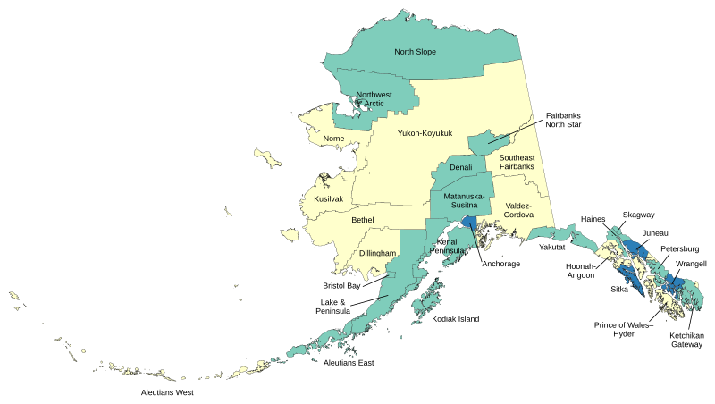
English: Map of boroughs and census areas in Alaska. Green=boroughs, Blue=consolidated city-boroughs, Yellow=census areas (unorganized borough). |
| Datum | |
| Quelle | Eigenes Werk |
| Urheber | Lasunncty |
Made with data from the US Census Bureau.
Lizenz
Ich, der Urheber dieses Werkes, veröffentliche es unter der folgenden Lizenz:
Diese Datei ist unter der Creative-Commons-Lizenz „Namensnennung – Weitergabe unter gleichen Bedingungen 3.0 nicht portiert“ lizenziert.
- Dieses Werk darf von dir
- verbreitet werden – vervielfältigt, verbreitet und öffentlich zugänglich gemacht werden
- neu zusammengestellt werden – abgewandelt und bearbeitet werden
- Zu den folgenden Bedingungen:
- Namensnennung – Du musst angemessene Urheber- und Rechteangaben machen, einen Link zur Lizenz beifügen und angeben, ob Änderungen vorgenommen wurden. Diese Angaben dürfen in jeder angemessenen Art und Weise gemacht werden, allerdings nicht so, dass der Eindruck entsteht, der Lizenzgeber unterstütze gerade dich oder deine Nutzung besonders.
- Weitergabe unter gleichen Bedingungen – Wenn du das Material wiedermischst, transformierst oder darauf aufbaust, musst du deine Beiträge unter der gleichen oder einer kompatiblen Lizenz wie das Original verbreiten.
Dateiversionen
Klicke auf einen Zeitpunkt, um diese Version zu laden.
| Version vom | Vorschaubild | Maße | Benutzer | Kommentar | |
|---|---|---|---|---|---|
| aktuell | 12:30, 2. Jun. 2020 | | 816 × 461 (334 KB) | Lasunncty | Reverted to version as of 04:02, 14 December 2016 (UTC) - Confused Petersburg Census area with Petersburg Borough |
| 14:37, 1. Jun. 2020 |  | 816 × 461 (477 KB) | BorderRegions | Fixed Petersburg Borough borders, and Hoonah–Angoon Census Area border - both of which did not have included all their appropriate territory. Previous two versions didn't actually register changes. | |
| 13:49, 1. Jun. 2020 |  | 1.168 × 648 (246 KB) | BorderRegions | Fixed Petersburg Borough borders, and Hoonah–Angoon Census Area border - both of which did not have included all their appropriate territory. | |
| 13:40, 1. Jun. 2020 |  | 1.168 × 648 (124 KB) | BorderRegions | Fixed Petersburg Borough borders, and Hoonah–Angoon Census Area border - both of which did not have included all their appropriate territory. | |
| 06:02, 14. Dez. 2016 |  | 816 × 461 (334 KB) | Kingofthedead | Kusilvak | |
| 11:00, 9. Jun. 2015 |  | 816 × 461 (334 KB) | Lasunncty | Corrected Haines and Yakutat. Not actually unified government despite their names. | |
| 11:18, 24. Dez. 2014 |  | 816 × 461 (334 KB) | Lasunncty | New map as of Jan 2013 |
Dateiverwendung
Die folgende Seite verwendet diese Datei:
Globale Dateiverwendung
Die nachfolgenden anderen Wikis verwenden diese Datei:
- Verwendung auf zh.wikipedia.org