| Tafkas/Mount Katmai | ||
|---|---|---|

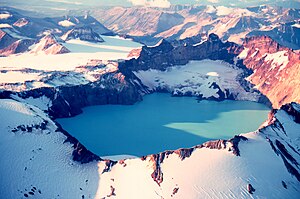
Der Mount Katmai mit Kratersee im September 1980 | ||
| Höhe | 2,047 m | |
| Lage | Alaska-Halbinsel (USA) | |
| Gebirge | Aleutenkette | |
| Koordinaten | 58° 15′ 27″ N, 154° 58′ 33″ W keine Zahl: 2.047 | |
|
| ||
| Typ | Stratovulkan | |
| Letzte Eruption | Juni 1912 [1] | |
Der Mount Katmai ist ein Stratovulkan auf der Alaska-Halbinsel im Katmai-Nationalpark im Süden des US-Bundesstaates Alaska. Der zur Aleutenkette zählende Vulkan hat bei einer Höhe von 2.047 m einen Durchmesser von etwa 10 Kilometern. Sein Zentrum bildet eine 4,5 mal 3 km große Caldera auf etwa 1.040 m Höhe. Der Wasserspiegel des darin befindlichen Kratersees reichte 1975 bis auf 1.286 m
Geologie
Der Mount Katmai gehört zu den fünf Kratern die den Novarupta umgeben, der 1912 mit einem verheerenden Ausbruch den Ort der größten Vulkaneruption des 20. Jahrhunderts markiert und das Valley of Ten Thousand Smokes bildete. Der Katmai besteht vorwiegend aus Lavaströmen und pyroklastischem Material. Die quartären vulkanischen Gesteine und die angrenzenden Schlacken und Aschen haben eine Dicke von unter 1500 m. Ein Großteil des Vulkans ist von Schnee und Eis bedeckt und mehrere Talgletscher umgeben den Katmai an seinen Flanken. Vom oberen Rand der Caldera fließen drei Gletscher in Richtung Kratersee. Der Katmai liegt auf Sedimentgestein des späten Jura, welches im Westen, Norden und Südosten des Kraters auf einer Höhe von etwa 1.520 frei liegt. Auch in der Westwand der Caldera bei 1.830 m sowie am Fuß der Ostwand auf 1,040 m gibt es freiliegendes Sedimentgestein.
Vulkanische Aktivität
Über die vulkanische Aktivität des Vulkans vor der Eruption von 1912 ist wenig bekannt. Ältere Karten der U.S. Coast and Geodetic Survey deuten darauf hin, dass der Gipfel vor Entstehung der Caldera bei etwa 2300 m lag. 1898 berichteten Einheimische von gelegentlicher Rauchentwicklung an einem der Vulkane der Gegend.
Vom 6. bis zum 8. Juni 1912 ereignete sich im Gebiet des Katmai die größte historisch aufgezeichnete Eruption in der Geschichte Alaskas, welche gleichzeitig die größte Eruption des 20. Jahrhunderts weltweit darstellt. Dabei bildete sich eine rießige Caldera am Gipfel des Mount Katmai. Die etwa 60 Stunden andauernde Eruption fand aber tatsächlich nicht am Katmai selbst statt, sondern etwa 10 km westlich des Vulkans am Novarupta. Die Eruption förderte geschätzte 30 bis 35 km³ pyroklastisches Material.
Based on geochemical and structural relationships, it has been suggested that magma drained from beneath Katmai Volcano to Novarupta via the plumbing system beneath Trident Volcano. The withdrawal of magma beneath Katmai resulted in the collapse of the summit area, forming the caldera. Following the subsidence, a small dacitic cinder cone was emplaced on the floor of the caldera; this is the only juvenile material erupted from Katmai caldera during the historical eruption.
Approximately 12-15 km³ of magma was vented during the 1912 eruption producing about 35 km³ of tephra. An estimated 11-15 km³ of ash flow tuff traveled Vorlage:Convert northwest covering an area of about 120 km² in what subsequently came to be known as the Valley of Ten Thousand Smokes. The ash flow tuff produced in the 1912 eruption is made up of a silica-rich volcanic rock called rhyolite. In fact, this is the only major Quaternary eruption of rhyolite to have occurred in Alaska. Maximum thickness of the ashflow is estimated to be about Vorlage:Convert. About 20 km³ of airfall tephra was carried east and southeast with a minor lobe to the north covering 77,000 km² with more than 1 in (2.5 cm) of ash. Light ash fall was reported as far away as the Puget Sound region Vorlage:Convert away. Extremely fine ash blown into the stratosphere remained in suspension as aerosols for months and caused spectacular red sunsets in many parts of the world.
In 1919, geologists noted a lake covering a large part of the caldera floor, but by 1923 the lake was gone and numerous fumaroles, mud pots, and a large mud geyser had replaced it. The lake has since refilled to a depth of over Vorlage:Convert. Small glaciers have also formed on a bench within the caldera beside the lake.
Quellen
- Alaska Volcano Observatory: Katmai
- Charles Arthur Wood, Jürgen Kienle: Volcanoes of North America : The United States and Canada. Cambridge University Press, 1990 ISBN 978-0-521-43811-7
