Schlammvulkane von Poto
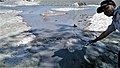
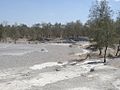
Die Schlammvulkane von Poto (Area Poto Mud Volcano) bilden eine Fläche von Schlammvulkanen im osttimoresischen Suco Bobometo (Verwaltungsamt Oesilo, Sonderverwaltungsregion Oe-Cusse Ambeno).[1] Sie befinden sich südlich vom Dorf Saben, nahe der Grenze zu Indonesien. Eine Straße führt an dem Gelände vorbei.
-
-

-
 Das Plakat warnt vor giftigen Gasen
 -


| |
Poto in Oe-Cusse Ambeno |
Literatur Bearbeiten
- Frederico Santos, José Manuel Pereira, António de Jesus Araújo: Mud volcano in East Timor: Constituent materials, the process, the geological structure and its interpretation, 2012.
Weblinks Bearbeiten
Commons: Schlammvulkane von Poto – Sammlung von Bildern, Videos und Audiodateien
Einzelnachweise Bearbeiten
- ↑ District Profile Oecussi Enclave, Democratic Republic of East Timor. Ministry of State Administration, Government of Timor-Leste, S. 3, 2002 (englisch);estatal.gov.tl (PDF; 687 kB).
Koordinaten: 9° 21′ 43,9″ S, 124° 22′ 37,9″ O