Mount Ruegg
Berg im ostantarktischen Viktorialand
Mount Ruegg ist ein 1870 m hoher Berg im ostantarktischen Viktorialand. In den Admiralitätsbergen ragt er an der Einmündung des DeAngelo-Gletschers in den Moubray-Gletscher auf.
| Mount Ruegg | ||
|---|---|---|

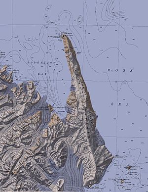
Topografische Karte mit Mount Ruegg (links unterhalb der Mitte) | ||
| Höhe | 1870 m | |
| Lage | Viktorialand, Ostantarktika | |
| Gebirge | Admiralitätsberge, Transantarktisches Gebirge | |
| Koordinaten | 71° 51′ 0″ S, 170° 11′ 0″ O | |
|
| ||
Das New Zealand Antarctic Place-Names Committee benannte ihn nach Harold Ruegg (1902–1990), nautischer Berater des Maritime New Zealand und Besucher der Rossmeerregion im Jahr 1956.
Weblinks
Bearbeiten- Mount Ruegg. In: Geographic Names Information System. United States Geological Survey, United States Department of the Interior, archiviert vom (englisch).
- Mount Ruegg auf geographic.org (englisch)
