Datei:A portion of the "Salt Palace" in the town of Grand Saline in Van Zandt County in northeast Texas LCCN2015630121.tif

Größe der JPG-Vorschau dieser TIF-Datei: 800 × 534 Pixel. Weitere Auflösungen: 320 × 214 Pixel | 640 × 427 Pixel | 1.024 × 683 Pixel | 1.280 × 854 Pixel | 2.560 × 1.709 Pixel | 7.360 × 4.912 Pixel
Originaldatei (7.360 × 4.912 Pixel, Dateigröße: 206,9 MB, MIME-Typ: image/tiff)
![]()
Diese Datei und die Informationen unter dem roten Trennstrich werden aus dem zentralen Medienarchiv Wikimedia Commons eingebunden.
![]()
Beschreibung
| Beschreibung |
English: Title: A portion of the "Salt Palace" in the town of Grand Saline in Van Zandt County in northeast Texas
Physical description: 1 photograph : digital, tiff file, color. Notes: It is said to be the only building in North America made of pure rock salt.; Gift; The Lyda Hill Foundation; 2014; (DLC/PP-2014:054).; Title, date and keywords based on information provided by the photographer.; Forms part of: Lyda Hill Texas Collection of Photographs in Carol M. Highsmith's America Project in the Carol M. Highsmith Archive.; Credit line: The Lyda Hill Texas Collection of Photographs in Carol M. Highsmith's America Project, Library of Congress, Prints and Photographs Division. |
||||||||||||||||||||||||||
| Datum | Aufgenommen am 22. Mai 2014, 14:04 (gemäß Exif-Daten) | ||||||||||||||||||||||||||
| Quelle |
Library of Congress
|
||||||||||||||||||||||||||
| Urheber |
|
||||||||||||||||||||||||||
| Genehmigung (Weiternutzung dieser Datei) |
No known restrictions on publication.
|
||||||||||||||||||||||||||


| Kameraposition | | Dieses und weitere Bilder auf OpenStreetMap |
|---|
Lizenz
| Dieses Werk stammt aus der Carol M. Highsmith Archive-Sammlung der Library of Congress. Laut der Bibliothek gibt es keine bekannten Copyright-Einschränkungen in der Verwendung dieses Werkes. Carol M. Highsmith has stipulated that her photographs are in the public domain. Photographs of sculpture or other works of art may be restricted by the copyright of the artist. |
 |
Dateiversionen
Klicke auf einen Zeitpunkt, um diese Version zu laden.
| Version vom | Vorschaubild | Maße | Benutzer | Kommentar | |
|---|---|---|---|---|---|
| aktuell | 15:55, 8. Sep. 2016 | 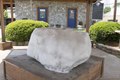 | 7.360 × 4.912 (206,9 MB) | Fæ | LOC 2015630121, Carol M. Highsmith collection. P85.12770 TIFF (206.9mb) |
| 15:55, 8. Sep. 2016 |  | 7.360 × 4.912 (206,9 MB) | Fæ | LOC 2015630121, Carol M. Highsmith collection. P85.12770 TIFF (206.9mb) |
Dateiverwendung
Die folgende Seite verwendet diese Datei: