Datei:Wilderness May6 1100.png
Größe dieser Vorschau: 685 × 599 Pixel. Weitere Auflösungen: 274 × 240 Pixel | 549 × 480 Pixel | 878 × 768 Pixel | 1.171 × 1.024 Pixel | 2.307 × 2.018 Pixel
Originaldatei (2.307 × 2.018 Pixel, Dateigröße: 1,24 MB, MIME-Typ: image/png)
![]()
Diese Datei und die Informationen unter dem roten Trennstrich werden aus dem zentralen Medienarchiv Wikimedia Commons eingebunden.
![]()
| Beschreibung |
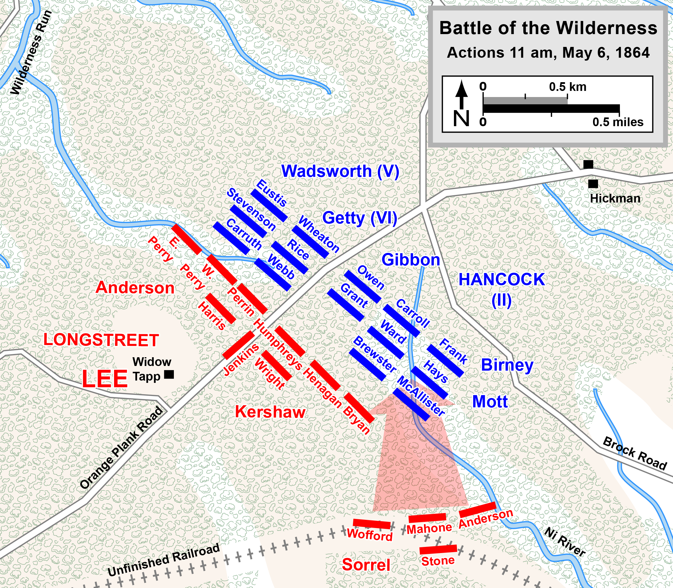
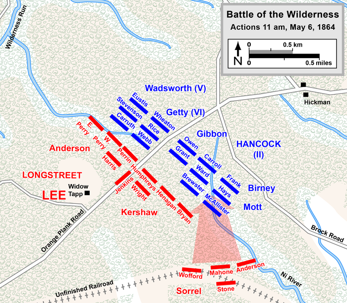
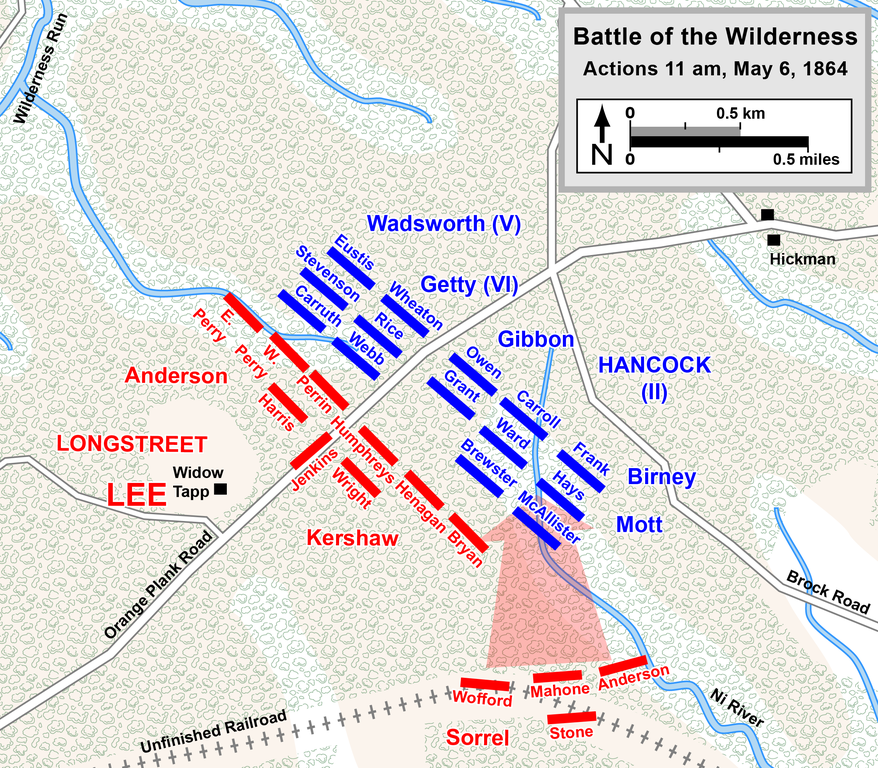
English: Map of a portion of the Battle of the Wilderness of the American Civil War. Drawn in Adobe Illustrator CC 2015 by Hal Jespersen. Graphic source file is available at http://www.CWmaps.com/ Rhea, Gordon C. (1994) The Battle of the Wilderness, May 5–6, 1864, Baton Rouge, LA: Louisiana State University Press ISBN: 978-08071-1873-3.
Diese Datei ist unter der Creative-Commons-Lizenz „Namensnennung 3.0 nicht portiert“ lizenziert. Namensnennung: Map by Hal Jespersen, www.CWmaps.com
|
| Datum | |
| Quelle | Eigenes Werk (Map is comparable to map on page 352 of The Battle of the Wilderness May 5-6, 1864, by Gordon C. Rhea) |
| Urheber | Hlj |
Dateiversionen
Klicke auf einen Zeitpunkt, um diese Version zu laden.
| Version vom | Vorschaubild | Maße | Benutzer | Kommentar | |
|---|---|---|---|---|---|
| aktuell | 23:36, 16. Okt. 2015 | | 2.307 × 2.018 (1,24 MB) | Hlj | Fix typos and make minor graphical improvements. Same license. |
| 22:03, 17. Mär. 2011 |  | 1.153 × 1.009 (536 KB) | Hlj | Minor graphical changes to conform to new ACW map style for roads and rivers. Same license. | |
| 02:57, 21. Okt. 2010 |  | 1.153 × 1.009 (502 KB) | Hlj | {{Information |Description={{en|1=Map of a portion of the Battle of the Wilderness of the American Civil War. Drawn in Adobe Illustrator CS5 by Hal Jespersen. Graphic source file is available at http://www.posix.com/CWmaps/ {{cc-by-3.0|Map by Hal |
Dateiverwendung
Die folgende Seite verwendet diese Datei:
Globale Dateiverwendung
Die nachfolgenden anderen Wikis verwenden diese Datei:
- Verwendung auf en.wikipedia.org
- Verwendung auf fr.wikipedia.org
- Verwendung auf hu.wikipedia.org
- Verwendung auf hy.wikipedia.org
- Verwendung auf nl.wikipedia.org
- Verwendung auf ru.wikipedia.org