Datei:Visurgis ab inclyta Brema ad ostium maris 1648 1653 1686.jpg
Größe dieser Vorschau: 800 × 293 Pixel. Weitere Auflösungen: 320 × 117 Pixel | 640 × 234 Pixel | 1.024 × 375 Pixel | 1.280 × 469 Pixel | 5.150 × 1.885 Pixel
Originaldatei (5.150 × 1.885 Pixel, Dateigröße: 8,14 MB, MIME-Typ: image/jpeg)
![]()
Diese Datei und die Informationen unter dem roten Trennstrich werden aus dem zentralen Medienarchiv Wikimedia Commons eingebunden.
![]()
Beschreibung
| Beschreibung |
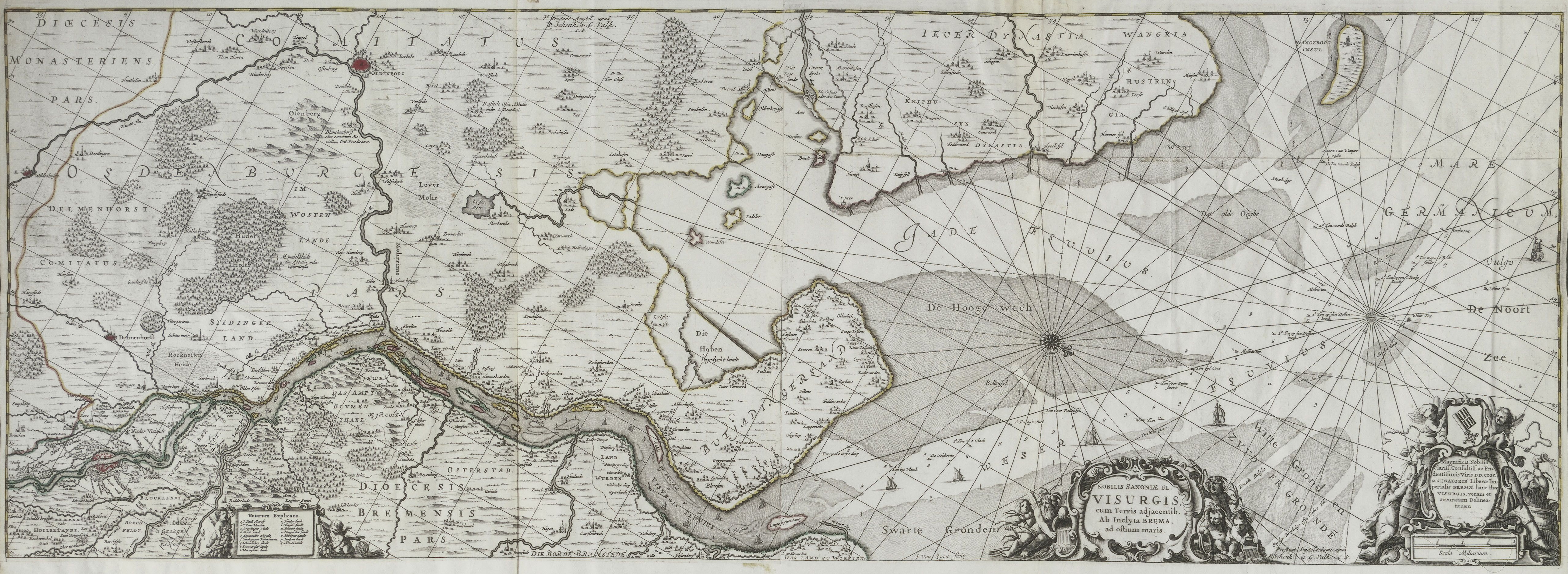
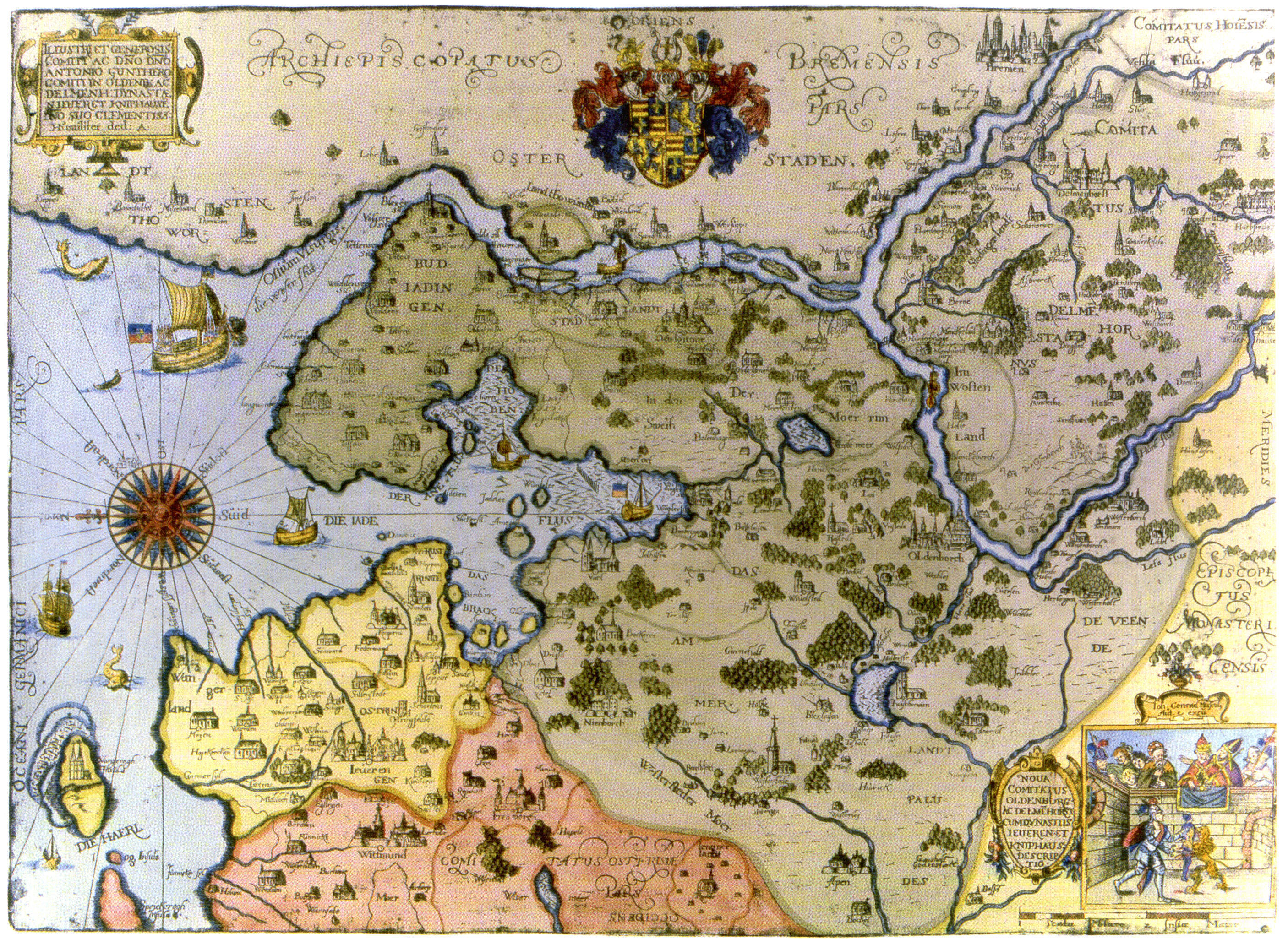
Original title: NOBILIS SAXONIÆ FL. VISURGIS, cum Terris adjacentib. Ab Inclyta BREMA ad oſtium maris. It is a very close copy or a major relaunch (of the copper plate) by Jan van Loon of a map first edited by Matthaeus Merian the Younger and his brother Caspar Merian in 1653 as a part of their Topographia Saxoniæ inferioris, but showing the depicted region in the period between 1643 (completion of New Hobendeich) and 1648 (conversion of the Bishopric of Bremen into the Duchy of Bremen). Besides the lower part of the Weser, it shows the whole coastline of the County of Oldenburg. In many details and in the forest signatures of the merian vesion, the map resembles the New Map of the county of Oldenburg drawn in 1632 and printed in 1650 by Johann Conrad Musculus (who was employed by the earls of Oldenburg), actualized by features mapped by the same author, see eastern part of Jade Bight in 1645. Changes from the Merian to the Loon version, edited by Peter Schenk the Elder and Gerard Valck (FR, NL): Most text (names) have been renewed, but with very few changes of the spelling. The Merian version had a star of compass lines only on sea, the Loon version in addition has a north-aligned grid both on sea and on land. Forests are symbolized by crowds of single trees, now. The positions of key and scale have been changed, and a dedication plaque of the senate of Bremen city has been added. The Loon version is extended farther north, but also the Merian version shows elements of a second system of compass lines that has its center in the part of the map not included in their edition. Probably, they have used a larger map and cut off a part showing little more then sea, in order to adapt it for their folio. |
| Datum | period shown 1643_1648, first edition 1653, digitized print 1686 / 1715 |
| Quelle | http://biblio.unibe.ch/web-apps/maps/lightbox.php?col=ryh&pic=Ryh_5207_21&col=ryh&ilang=DE |
| Urheber | drawn by Johann Conrad Musculus(?), first edition by Matthäus (jr.) and Caspar Merian, revision by Jan van Loon, upload Ulamm (Diskussion) 17:24, 4 January 2015 (UTC) |
| Andere Versionen | File:Unterweser Jadebusen 1643-48.jpg, scan of the Merian version (= first plate), 7,518 × 3,132 pixels |
Lizenz
|
Dieses Werk ist gemeinfrei, weil seine urheberrechtliche Schutzfrist abgelaufen ist. | |
| Es wurde festgestellt, dass diese Datei frei von bekannten Beschränkungen durch das Urheberrecht ist, alle verbundenen und verwandten Rechte eingeschlossen. | |
Dateiversionen
Klicke auf einen Zeitpunkt, um diese Version zu laden.
| Version vom | Vorschaubild | Maße | Benutzer | Kommentar | |
|---|---|---|---|---|---|
| aktuell | 19:24, 4. Jan. 2015 | 5.150 × 1.885 (8,14 MB) | Ulamm | {{Information |Description=Original title: ''NOBILIS SAXONIÆ FL. VISURGIS, cum Terris adjacentib. Ab Inclyta BREMA ad oſtium maris''. It is a very close copy or a major relaunch (of the plate) by Jan van Loon of a map first edited by [[:en:|Matthaeus... |
Dateiverwendung
Die folgende Seite verwendet diese Datei: