Datei:Stjohnsriver detailmap.png

Größe dieser Vorschau: 412 × 599 Pixel. Weitere Auflösungen: 165 × 240 Pixel | 330 × 480 Pixel | 1.000 × 1.455 Pixel
Originaldatei (1.000 × 1.455 Pixel, Dateigröße: 890 KB, MIME-Typ: image/png)
![]()
Diese Datei und die Informationen unter dem roten Trennstrich werden aus dem zentralen Medienarchiv Wikimedia Commons eingebunden.
![]()
Beschreibung
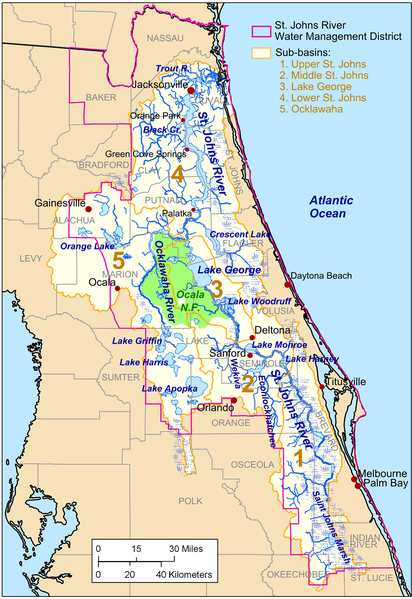
| Beschreibung | Map of the w:St. Johns River drainage basin. |
| Datum | |
| Quelle | Eigenes Werk. City, county, and drainage basin data source: National Atlas[1]. Hydrology data source: National Hydrography Dataset [2]. St. Johns River Management District boundary source: St. Johns River Management District [3]. |
| Urheber | Kmusser |
| Andere Versionen | File:Stjohnsriver detailmap.svg |
Lizenz
Ich, der Urheberrechtsinhaber dieses Werkes, veröffentliche es hiermit unter der folgenden Lizenz:
Diese Datei ist unter der Creative-Commons-Lizenz „Namensnennung – Weitergabe unter gleichen Bedingungen 3.0 nicht portiert“ lizenziert.
- Dieses Werk darf von dir
- verbreitet werden – vervielfältigt, verbreitet und öffentlich zugänglich gemacht werden
- neu zusammengestellt werden – abgewandelt und bearbeitet werden
- Zu den folgenden Bedingungen:
- Namensnennung – Du musst angemessene Urheber- und Rechteangaben machen, einen Link zur Lizenz beifügen und angeben, ob Änderungen vorgenommen wurden. Diese Angaben dürfen in jeder angemessenen Art und Weise gemacht werden, allerdings nicht so, dass der Eindruck entsteht, der Lizenzgeber unterstütze gerade dich oder deine Nutzung besonders.
- Weitergabe unter gleichen Bedingungen – Wenn du das Material wiedermischst, transformierst oder darauf aufbaust, musst du deine Beiträge unter der gleichen oder einer kompatiblen Lizenz wie das Original verbreiten.

|
Es ist erlaubt, die Datei unter den Bedingungen der GNU-Lizenz für freie Dokumentation, Version 1.2 oder einer späteren Version, veröffentlicht von der Free Software Foundation, zu kopieren, zu verbreiten und/oder zu modifizieren; es gibt keine unveränderlichen Abschnitte, keinen vorderen und keinen hinteren Umschlagtext.
Der vollständige Text der Lizenz ist im Kapitel GNU-Lizenz für freie Dokumentation verfügbar. |
Du darfst es unter einer der obigen Lizenzen deiner Wahl verwenden.
Dateiversionen
Klicke auf einen Zeitpunkt, um diese Version zu laden.
| Version vom | Vorschaubild | Maße | Benutzer | Kommentar | |
|---|---|---|---|---|---|
| aktuell | 19:30, 19. Okt. 2009 | | 1.000 × 1.455 (890 KB) | Kmusser | Bold basin labels |
| 18:56, 19. Okt. 2009 |  | 1.000 × 1.455 (890 KB) | Kmusser | Increased font sizes | |
| 18:20, 19. Okt. 2009 |  | 1.000 × 1.455 (851 KB) | Kmusser | font size test | |
| 03:33, 16. Okt. 2009 |  | 1.000 × 1.455 (926 KB) | Kmusser | == Summary == {{Information |Description= Map of the w:St. Johns River drainage basin. |Source={{own}}. City, county, and drainage basin data source: National Atlas[http://www.nationalatlas.gov/]. Hydrology data source: National Hydrography Dataset |
Dateiverwendung
Die folgende Seite verwendet diese Datei:
Globale Dateiverwendung
Die nachfolgenden anderen Wikis verwenden diese Datei:
- Verwendung auf azb.wikipedia.org
- Verwendung auf ceb.wikipedia.org
- Verwendung auf en.wikipedia.org
- Verwendung auf eo.wikipedia.org
- Verwendung auf fr.wikipedia.org
- Verwendung auf it.wikipedia.org
- Verwendung auf ja.wikipedia.org
- Verwendung auf pl.wikipedia.org
- Verwendung auf sr.wikipedia.org
- Verwendung auf th.wikipedia.org
- Verwendung auf uk.wikipedia.org
- Verwendung auf www.wikidata.org
- Verwendung auf zh.wikipedia.org