Datei:Satellite Image of Earth's Interrelated Systems and Climate - GPN-2002-000121.jpg

Größe dieser Vorschau: 600 × 600 Pixel. Weitere Auflösungen: 240 × 240 Pixel | 480 × 480 Pixel | 768 × 768 Pixel | 1.024 × 1.024 Pixel | 2.350 × 2.350 Pixel
Originaldatei (2.350 × 2.350 Pixel, Dateigröße: 1,28 MB, MIME-Typ: image/jpeg)
![]()
Diese Datei und die Informationen unter dem roten Trennstrich werden aus dem zentralen Medienarchiv Wikimedia Commons eingebunden.
![]()
| Beschreibung |
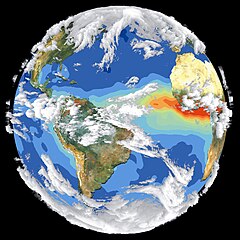
English: Satellite data and images such as those presented in this image of Earth give scientists a more comprehensive view of the Earth's interrelated systems and climate. Four different satellites contributed to the making of this image. Sea-viewing Wide Field-of-view Sensor (SeaWiFS) provided the land image layer and is a true color composite of land vegetation for cloud-free conditions from September 18 to October 3, 1997. Each red dot over South America and Africa represents a fire detected by the Advanced Very High Resolution Radiometer. The oceanic aerosol layer is based on National Oceanic and Atmospheric Administration (NOAA) data and is caused by biomass burning and windblown dust over Africa. The cloud layer is a composite of infrared images from four geostationary weather satellites?NOAA's GOES 8 and 9, the European Space Agency's METEOSAT, and Japan's GMS 5. |
|||||
| Datum | ||||||
| Quelle | Great Images in NASA Description | |||||
| Urheber | NASA | |||||
| Genehmigung (Weiternutzung dieser Datei) |
|

Diese Mediendatei wurde vom Goddard Space Flight Center der US-amerikanischen National Aeronautics and Space Administration (NASA) unter der Datei-ID GPN-2002-000121 UND der Alternativen Datei-ID 119 kategorisiert. Diese Markierung zeigt nicht den Urheberrechtsstatus des zugehörigen Werks an. Es ist in jedem Falle zusätzlich eine normale Lizenzvorlage erforderlich. Siehe Commons:Lizenzen für weitere Informationen. Sprachen:
|
Dateiversionen
Klicke auf einen Zeitpunkt, um diese Version zu laden.
| Version vom | Vorschaubild | Maße | Benutzer | Kommentar | |
|---|---|---|---|---|---|
| aktuell | 09:50, 14. Apr. 2015 | | 2.350 × 2.350 (1,28 MB) | Jcpag2012 | cropped from black borders |
| 00:54, 10. Apr. 2009 |  | 2.700 × 3.214 (2,91 MB) | BotMultichillT | {{Information |Description={{en|1=Satellite data and images such as those presented in this image of Earth give scientists a more comprehensive view of the Earth's interrelated systems and climate. Four different satellites contributed to the making of th |
Dateiverwendung
Die folgende Seite verwendet diese Datei:
Globale Dateiverwendung
Die nachfolgenden anderen Wikis verwenden diese Datei:
- Verwendung auf ar.wikipedia.org
- Verwendung auf el.wikipedia.org
- Verwendung auf en.wikipedia.org
- Verwendung auf it.wikipedia.org
- Verwendung auf no.wikipedia.org