Datei:SI-metrication-world.png
Größe dieser Vorschau: 800 × 411 Pixel. Weitere Auflösungen: 320 × 164 Pixel | 640 × 329 Pixel | 1.024 × 526 Pixel | 1.280 × 657 Pixel | 2.000 × 1.027 Pixel
Originaldatei (2.000 × 1.027 Pixel, Dateigröße: 335 KB, MIME-Typ: image/png)
![]()
Diese Datei und die Informationen unter dem roten Trennstrich werden aus dem zentralen Medienarchiv Wikimedia Commons eingebunden.
![]()
Beschreibung
| Beschreibung |
English:
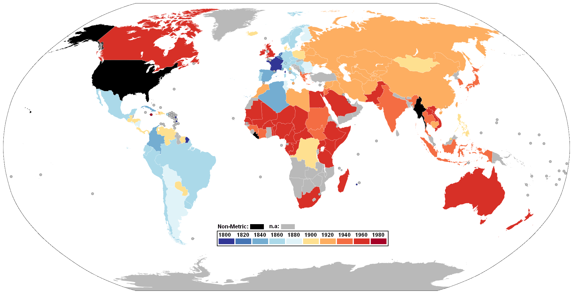
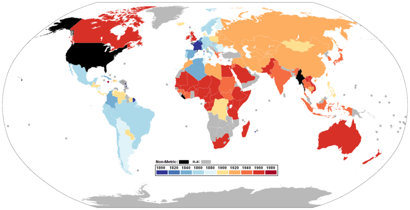
English (en): This nation has adopted the metric system by:
1800 1820 1840 1860 1880 1900 1920 1940 1960 1980 Data currently not available. Countries which have not adopted the metric system.
(Note regarding the United Kingdom and the United States: Data indicates UK was metric in the 1960s – they made a decision to go metric in the 1960s and made a legal commitment to do so in 1973 as part of its conditions for membership in the EEC (now the EU), but then did little about the decision. The UK now uses a combination of metric and imperial units however, and it is illegal to sell products weighed only in imperial measurements but imperial units may be shown alongside metric weights; imperial measurements have not been taught in schools since the 1970s but most adults and children know their height and weight only in imperial units. The European Union no longer requires the United Kingdom to convert completely to metric. This is similar to the situation occurring in the US, where metric is a legal system for lengths and weights, though its metrication process has been very slow due to public pressure and lack of funding.)
Deutsch:
Deutsch (de): Dieser Staat übernahm das metrische Einheitensystem vor:
1800 1820 1840 1860 1880 1900 1920 1940 1960 1980 Momentan keine Daten verfügbar Diese Nation hat das metrische System nicht übernommen.
Français :
français (fr): Cette nation a adopté le système métrique avant:
1800 1820 1840 1860 1880 1900 1920 1940 1960 1980 Les données actuellement non disponibles. Les États qui n'ont pas adopté le système métrique.
Italiano:
italiano (it): La nazione ha adottato il Sistema internazionale di unità di misura a partire dall'anno:
1800 1820 1840 1860 1880 1900 1920 1940 1960 1980 Al momento nessun dato disponibile Questa nazione non ha adottato il sistema internazionale.
Nederlands:
Nederlands (nl): Dit land heeft het metrieke stelsel aangenomen per:
1800 1820 1840 1860 1880 1900 1920 1940 1960 1980 Gegevens ontbreken. Landen die het metrieke stelsel niet hebben aangenomen.
Polski:
polski (pl): Te państwa przyjęły system metryczny w:
1800 1820 1840 1860 1880 1900 1920 1940 1960 1980 Dane nie są obecnie dostępne. Kraje, które nie przyjęły systemu metrycznego.
Português:
português (pt): Esta nação adoptou o sistema métrico pelo ano:
1800 1820 1840 1860 1880 1900 1920 1940 1960 1980 Dados actualmente indisponíveis. Países que não adoptaram o sistema métrico.
Русский: русский (ru): Государства, принявшие метрическую систему в:
1800 г. 1820 г. 1840 г. 1860 г. 1880 г. 1900 г. 1920 г. 1940 г. 1960 г. 1980 г. Данные в настоящее время не доступны. Государства, которые не приняли метрическую систему.
|
|||
| Datum | 25. Juli 2006 (Original-Hochladedatum) | |||
| Quelle | Die Autorenschaft wurde nicht in einer maschinell lesbaren Form angegeben. Es wird angenommen, dass es sich um ein eigenes Werk handelt (basierend auf den Rechteinhaber-Angaben). | |||
| Urheber | Die Autorenschaft wurde nicht in einer maschinell lesbaren Form angegeben. Es wird Seabhcán als Autor angenommen (basierend auf den Rechteinhaber-Angaben). | |||
| Andere Versionen |
Abgeleitete Werke dieser Datei: SI-metrication-world-2009-14-04.png:
|


.svg)


Lizenz
| Diese Datei ist unter der Creative-Commons-Lizenz „Namensnennung – Weitergabe unter gleichen Bedingungen 3.0 nicht portiert“ lizenziert. Vorbehaltlich der Haftungsausschlüsse. | ||
| ||
| Diese Lizenzmarkierung wurde auf Grund der GFDL-Lizenzaktualisierung hinzugefügt. |

|
Es ist erlaubt, die Datei unter den Bedingungen der GNU-Lizenz für freie Dokumentation, Version 1.2 oder einer späteren Version, veröffentlicht von der Free Software Foundation, zu kopieren, zu verbreiten und/oder zu modifizieren; es gibt keine unveränderlichen Abschnitte, keinen vorderen und keinen hinteren Umschlagtext.
Der vollständige Text der Lizenz ist im Kapitel GNU-Lizenz für freie Dokumentation verfügbar. Vorbehaltlich der Haftungsausschlüsse. |
Dateiversionen
Klicke auf einen Zeitpunkt, um diese Version zu laden.
| Version vom | Vorschaubild | Maße | Benutzer | Kommentar | |
|---|---|---|---|---|---|
| aktuell | 23:05, 8. Jan. 2018 | | 2.000 × 1.027 (335 KB) | Maphobbyist | Added color bar. |
| 22:56, 8. Jan. 2018 |  | 2.000 × 1.027 (264 KB) | Maphobbyist | Colormap adjusted for the colorblind. | |
| 11:23, 27. Dez. 2017 |  | 1.357 × 700 (46 KB) | Maphobbyist | Namibia was metricated at the same time as South Africa, when it was under South African rule. | |
| 02:04, 9. Jul. 2011 |  | 1.357 × 700 (54 KB) | Maphobbyist | South Sudan has become independent on July 9, 2011. Sudan and South Sudan are shown with the new international border between them. | |
| 17:35, 14. Mär. 2011 |  | 1.357 × 700 (53 KB) | Maphobbyist | Note: In Canada (except the Canadian province of Quebec which has been fully metricated) the metrication process is still not complete. | |
| 12:05, 31. Jul. 2010 |  | 1.357 × 700 (52 KB) | Maphobbyist | Colored Hawaii and the Alaskan islands in black as they are part of the USA. | |
| 12:23, 26. Jun. 2008 |  | 1.357 × 700 (24 KB) | Soap | revert: old version was 20 times smaller, and new version is not any easier to distinguish colors in, as far I can see | |
| 01:31, 30. Mär. 2008 |  | 1.357 × 700 (454 KB) | Brhaspati | Colorblind-safe version. Please avoid red/green gradients - 7% of male readers cannot distinguish between the colors reliably. | |
| 15:30, 31. Mär. 2007 |  | 1.357 × 700 (24 KB) | Fred J | color UK orange | |
| 02:07, 11. Jan. 2007 |  | 1.357 × 700 (36 KB) | Roke~commonswiki | fix tierra del fuego |
Dateiverwendung
Die folgende Seite verwendet diese Datei:
Globale Dateiverwendung
Die nachfolgenden anderen Wikis verwenden diese Datei:
- Verwendung auf en.wikipedia.org