Datei:Receding waters ESA19317085.jpeg

Originaldatei (7.521 × 4.231 Pixel, Dateigröße: 12,04 MB, MIME-Typ: image/jpeg)
![]()
Diese Datei und die Informationen unter dem roten Trennstrich werden aus dem zentralen Medienarchiv Wikimedia Commons eingebunden.
![]()
Beschreibung
| Beschreibung |
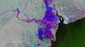
English: It is thought that well over a million people have been affected by what is probably the worst storm on record to hit the southern hemisphere. Making landfall on 15 March 2019, Cyclone Idai ripped through Mozambique, Malawi and Zimbabwe, razing buildings to the ground, destroying roads and inundating entire towns, villages and swathes of farmland. The human death toll is still unknown. While humanitarian efforts continue, people are now also facing the mammoth task of picking up the pieces and cleaning up after this devastating storm. This Copernicus Sentinel-1 image indicates where the flood waters are finally beginning to recede west of the port city of Beira in Mozambique. The image merges three separate satellite radar images from before the storm on 13 March, from one of the days when the floods were at their worst on 19 March, and as the waters are beginning to drain away on 25 March. The blue-purple colour indicates where floodwater is receding, while areas shown in red are still underwater. Images from Copernicus Sentinel-1 contributed to activations triggered in the Copernicus Emergency Management Service and the International Charter Space and Major Disasters. Both services take advantage of observations from several satellites and provide on-demand mapping to help civil protection authorities and the international humanitarian community in the face of major emergencies. Copernicus Sentinel-1 is a two-satellite mission, each carrying a radar instrument that can ‘see’ through clouds and rain, which makes it particularly useful for monitoring floods. As a constellation of two satellites orbiting 180° apart, the mission can repeat observations every six days, which is also useful for monitoring evolving situations. |
| Datum | 27. März 2019 (Hochladedatum) |
| Quelle | Receding waters |
| Urheber | European Space Agency |
| Andere Versionen |
|
| Activity | Observing the Earth |
| Mission | Sentinel-1 |
| System | Copernicus |
Lizenz

|
This image contains data from a satellite in the Copernicus Programme, such as Sentinel-1, Sentinel-2 or Sentinel-3. Attribution is required when using this image.
Namensnennung: Contains modified Copernicus Sentinel data 2019
The use of Copernicus Sentinel Data is regulated under EU law (Commission Delegated Regulation (EU) No 1159/2013 and Regulation (EU) No 377/2014). Relevant excerpts:
Free access shall be given to GMES dedicated data [...] made available through GMES dissemination platforms [...].
Access to GMES dedicated data [...] shall be given for the purpose of the following use in so far as it is lawful:
GMES dedicated data [...] may be used worldwide without limitations in time.
GMES dedicated data and GMES service information are provided to users without any express or implied warranty, including as regards quality and suitability for any purpose. |
This media was created by the European Space Agency (ESA).
Where expressly so stated, images or videos are covered by the Creative Commons Attribution-ShareAlike 3.0 IGO (CC BY-SA 3.0 IGO) licence, ESA being an Intergovernmental Organisation (IGO), as defined by the CC BY-SA 3.0 IGO licence. The user is allowed under the terms and conditions of the CC BY-SA 3.0 IGO license to Reproduce, Distribute and Publicly Perform the ESA images and videos released under CC BY-SA 3.0 IGO licence and the Adaptations thereof, without further explicit permission being necessary, for as long as the user complies with the conditions and restrictions set forth in the CC BY-SA 3.0 IGO licence, these including that:
See the ESA Creative Commons copyright notice for complete information, and this article for additional details.
|
 | |
Diese Datei ist lizenziert unter der Creative-Commons-Lizenz „Namensnennung – Weitergabe unter gleichen Bedingungen 3.0 IGO“. Namensnennung: ESA, CC BY-SA IGO 3.0
| ||
| Bildnotizen | Diese Datei ist annotiert: Betrachte diese auf Commons. |
Dateiversionen
Klicke auf einen Zeitpunkt, um diese Version zu laden.
| Version vom | Vorschaubild | Maße | Benutzer | Kommentar | |
|---|---|---|---|---|---|
| aktuell | 18:27, 21. Jun. 2020 | | 7.521 × 4.231 (12,04 MB) | OptimusPrimeBot | #Spacemedia - Upload of https://www.esa.int/var/esa/storage/images/esa_multimedia/images/2019/03/receding_waters/19317074-1-eng-GB/Receding_waters.jpg via Commons:Spacemedia |
Dateiverwendung
Die folgende Seite verwendet diese Datei:
Globale Dateiverwendung
Die nachfolgenden anderen Wikis verwenden diese Datei:
- Verwendung auf www.wikidata.org