Datei:Puget Sound faults.png
Größe dieser Vorschau: 360 × 600 Pixel. Weitere Auflösungen: 144 × 240 Pixel | 384 × 640 Pixel
Originaldatei (384 × 640 Pixel, Dateigröße: 612 KB, MIME-Typ: image/png)
![]()
Diese Datei und die Informationen unter dem roten Trennstrich werden aus dem zentralen Medienarchiv Wikimedia Commons eingebunden.
![]()
Beschreibung
| Beschreibung |
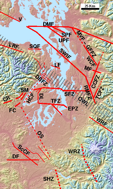
English: The principal w:Puget Sound faults (approximate location of known extents) and other selected peripheral and minor faults. Southern tip of Vancouver Island and San Juan Islands at top left (faults not shown), Olympic Mountains at center left, Mount Rainier at lower right (near WRZ). Faults top right: Devils Mountain, Strawberry Point, Utsalady Point, Mount Vernon, Southern Whidbey Island Fault, Cherry Creek Fault Zone, Tokul Creek Fault Zone, Rattlesnake Mountain Fault Zone. From upper left: Little River, Sequim, Lofall, Dabob Bay Fault Zone, Canyon River, Frigid Creek, Saddle Mountain faults, Hood Canal fault (questioned), Seattle Fault Zone, Dewatto lineament (concealed fault), Tacoma Fault Zone, East Passage Zone, White River (extends east), Olympia Structure, Scammon Creek, Doty (may extend west), Western Rainier Zone, Saint Helens Zone (extends south).
Also shown: part of the Olympic-Wallowa Lineament. Based on sources cited at w:Puget Sound faults. |
| Datum | |
| Quelle | Eigenes Werk |
| Urheber | J. Johnson (overlay) and Harvey Greenberg (Univ. of Washington, ESS) (base). |
| Genehmigung (Weiternutzung dieser Datei) |
Diese Datei ist unter der Creative-Commons-Lizenz „Namensnennung 3.0 nicht portiert“ lizenziert.
|
Lizenz
Ich, der Urheberrechtsinhaber dieses Werkes, veröffentliche es hiermit unter der folgenden Lizenz:
Diese Datei ist unter der Creative-Commons-Lizenz „Namensnennung – Weitergabe unter gleichen Bedingungen 3.0 nicht portiert“ lizenziert.
- Dieses Werk darf von dir
- verbreitet werden – vervielfältigt, verbreitet und öffentlich zugänglich gemacht werden
- neu zusammengestellt werden – abgewandelt und bearbeitet werden
- Zu den folgenden Bedingungen:
- Namensnennung – Du musst angemessene Urheber- und Rechteangaben machen, einen Link zur Lizenz beifügen und angeben, ob Änderungen vorgenommen wurden. Diese Angaben dürfen in jeder angemessenen Art und Weise gemacht werden, allerdings nicht so, dass der Eindruck entsteht, der Lizenzgeber unterstütze gerade dich oder deine Nutzung besonders.
- Weitergabe unter gleichen Bedingungen – Wenn du das Material wiedermischst, transformierst oder darauf aufbaust, musst du deine Beiträge unter der gleichen oder einer kompatiblen Lizenz wie das Original verbreiten.

|
Es ist erlaubt, die Datei unter den Bedingungen der GNU-Lizenz für freie Dokumentation, Version 1.2 oder einer späteren Version, veröffentlicht von der Free Software Foundation, zu kopieren, zu verbreiten und/oder zu modifizieren; es gibt keine unveränderlichen Abschnitte, keinen vorderen und keinen hinteren Umschlagtext.
Der vollständige Text der Lizenz ist im Kapitel GNU-Lizenz für freie Dokumentation verfügbar. |
Du darfst es unter einer der obigen Lizenzen deiner Wahl verwenden.
Dateiversionen
Klicke auf einen Zeitpunkt, um diese Version zu laden.
| Version vom | Vorschaubild | Maße | Benutzer | Kommentar | |
|---|---|---|---|---|---|
| aktuell | 00:15, 16. Okt. 2017 | | 384 × 640 (612 KB) | J. Johnson | Updated and revised faults in the Rogers Belt area, added GFFZ and Monroe fault, per 2016 mapping. |
| 01:30, 27. Dez. 2014 |  | 384 × 640 (678 KB) | J. Johnson | Adjusted locations and labels of MVF, LCF/WCF, CCFZ, per latest mapping. | |
| 22:27, 18. Dez. 2014 |  | 384 × 640 (678 KB) | J. Johnson | Adjusted Mount Vernon/Chaplain Lake fault and Cherry Creek FZ per latest information from DGER MS 2014-01 (Lake Chaplain). Also adjusted DMF. | |
| 22:56, 19. Jan. 2014 |  | 384 × 640 (676 KB) | J. Johnson | Setting to standard size of 384x640 pixels for image map. | |
| 00:50, 19. Jan. 2014 |  | 392 × 670 (731 KB) | J. Johnson | Reverted to version as of 00:03, 17 January 2014 -- 18 Jan. image flawed! should be deleted. | |
| 00:30, 19. Jan. 2014 |  | 378 × 640 (671 KB) | J. Johnson | Setting up a standard size (for imagemap). | |
| 02:03, 17. Jan. 2014 |  | 392 × 670 (731 KB) | J. Johnson | Revised "TF" (Tahuya fault) to "DL" (Dewatto Lineament); removed question mark from MVF; various adjustments of lines and labels, including making WRZ and SHZ look more like "dotted" lines. | |
| 00:47, 1. Jan. 2014 |  | 396 × 670 (739 KB) | J. Johnson | Updated to reflect deprecation of Hood Canal fault, addition of Dabob Bay fault zone, and extension of Cherry Creek fault zone, per sources listed in w:Puget Sound faults. | |
| 01:12, 17. Jan. 2013 |  | 394 × 670 (728 KB) | J. Johnson | Added Mount Vernon fault (representative of various faults in Rogers Belt), added Tokul Creek fault and clarified position vis-a-vis Cherry Creek Fault Zone, added "V" for Victoria, made several adjustments of position. | |
| 02:15, 18. Jan. 2012 |  | 394 × 669 (674 KB) | J. Johnson | Refined positions of some lines, extended RMFZ per DGER 2011-1 (Dragovich, et al.). |
Dateiverwendung
Die folgende Seite verwendet diese Datei:
Globale Dateiverwendung
Die nachfolgenden anderen Wikis verwenden diese Datei:
- Verwendung auf en.wikipedia.org