Datei:Pancam super res sol 2239 Endeavour.jpg
Originaldatei (4.096 × 1.401 Pixel, Dateigröße: 1,7 MB, MIME-Typ: image/jpeg)
![]()
Diese Datei und die Informationen unter dem roten Trennstrich werden aus dem zentralen Medienarchiv Wikimedia Commons eingebunden.
![]()
Beschreibung
| Beschreibung |
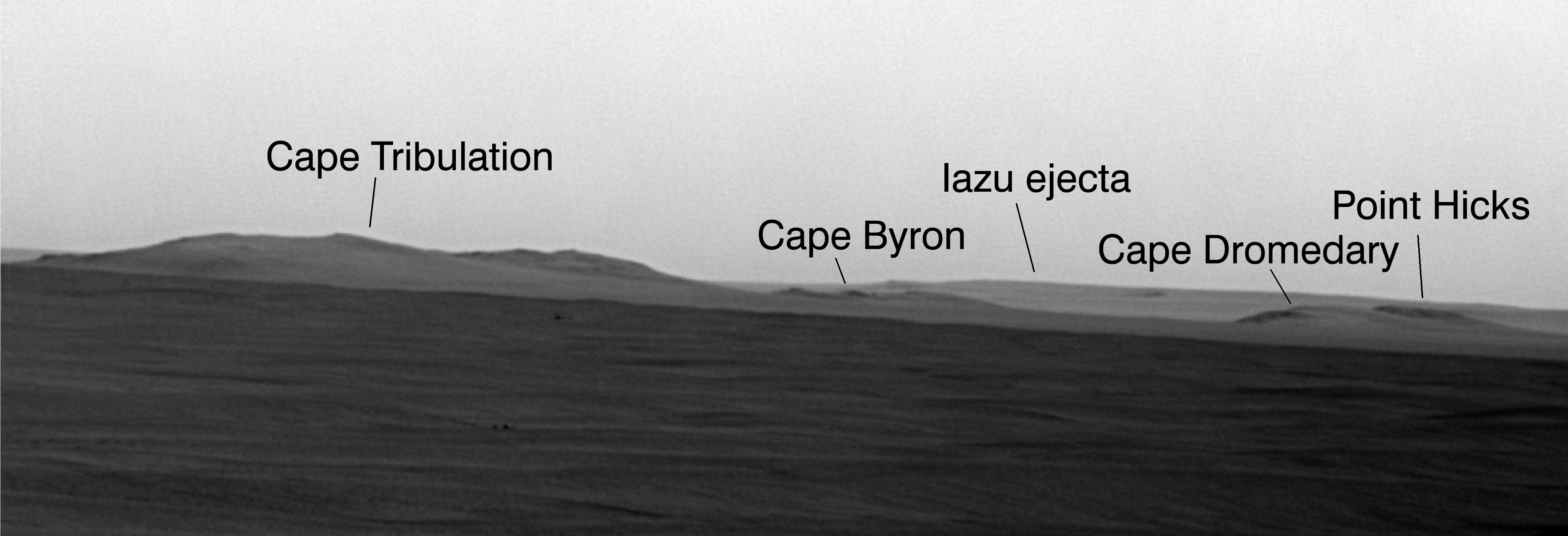
Deutsch: Hochauflösende Ansicht des Kraterrandes von Endeavour (Marskrater).
English: Since the summer of 2008, when NASA's Mars Exploration Rover Opportunity finished two years of studying Victoria Crater, the rover's long-term destination has been the much larger Endeavour Crater to the southeast. By the spring of 2010, Opportunity had covered more than a third of the charted, 19-kilometer (12-mile) route from Victoria to Endeavour and reached an area with a gradual, southward slope offering a view of Endeavour's elevated rim.
On the 2,239th Martian day, or sol, of Opportunity's mission on Mars (May 12, 2010), the rover used its panoramic camera (Pancam) to take multiple exposures of the horizon toward the southeast. The Pancam team combined these images into this super-resolution view showing details of a portion of the rim of Endeavour about 13 kilometers (8 miles) away, plus more-distant features. Super-resolution is an imaging technique that combines information from multiple pictures of the same target to generate an image with a higher resolution than any of the individual images. Above the dark plains in the lower portion of the view, the horizon in the left half is mostly a portion of Endeavour's western rim. Labels identify some points on the rim that have been assigned informal names by the rover science team, using as a theme names of places visited by British Royal Navy Capt. James Cook in his 1769-1771 Pacific voyage in command of H.M.S. Endeavour. The paler-looking terrain on the horizon beyond Endeavour in the right half of the image is part of a thick deposit of material ejected by the impact that excavated Iazu Crater, south of Endeavour. The observed increase in brightness of Iazu's ejecta relative to Endeavour's features is consistent with modeling by science team members Michael Wolff, of the Space Science Institute, Boulder, Colo., and Ray Arvidson, of Washington University in St. Louis, applying optical characteristics Opportunity has measured in the Martian atmosphere. |
| Datum | |
| Quelle | http://marsrovers.jpl.nasa.gov/gallery/press/opportunity/20100629a.html |
| Urheber | NASA/JPL-Caltech/Cornell University |
| Genehmigung (Weiternutzung dieser Datei) |
(Original text : gemäß http://www.jpl.nasa.gov/imagepolicy/ : By electing to download the material from this web site the user agrees: 1. (…) 2. to use a credit line in connection with images. Unless otherwise noted in the caption information for an image, the credit line should be "Courtesy NASA/JPL-Caltech." 3. that the endorsement of any product or service by Caltech, JPL or NASA must not be claimed or implied.) |
Lizenz
| Diese Datei ist gemeinfrei (public domain), da sie von der NASA erstellt worden ist. Die NASA-Urheberrechtsrichtlinie besagt, dass „NASA-Material nicht durch Urheberrecht geschützt ist, wenn es nicht anders angegeben ist“. (NASA-Urheberrechtsrichtlinie-Seite oder JPL Image Use Policy). | ||
 |
Warnung:
|
Ursprüngliches Datei-Logbuch
Übertragen aus de.wikipedia nach Commons durch Nachcommonsverschieber mithilfe des CommonsHelper.
- 2010-12-25 23:21 MoreInput 4096×1401× (1781841 bytes) {{Information |Beschreibung = Hochauflösende Ansicht des Kraterrandes von Endeavour (Marskrater). |Quelle = http://marsrovers.jpl.nasa.gov/gallery/press/opportunity/20100629a.html |Urheber = NASA/JPL-Caltech/Cornell University |Dat
Dateiversionen
Klicke auf einen Zeitpunkt, um diese Version zu laden.
| Version vom | Vorschaubild | Maße | Benutzer | Kommentar | |
|---|---|---|---|---|---|
| aktuell | 22:15, 23. Jan. 2013 | 4.096 × 1.401 (1,7 MB) | File Upload Bot (Magnus Manske) | Transfered from de.wikipedia by User:nachcommonsverschieber using CommonsHelper |
Dateiverwendung
Die folgenden 2 Seiten verwenden diese Datei:
Globale Dateiverwendung
Die nachfolgenden anderen Wikis verwenden diese Datei:
- Verwendung auf en.wikipedia.org
- Verwendung auf fr.wikipedia.org
- Verwendung auf lb.wikipedia.org
- Verwendung auf zh.wikipedia.org