Datei:OSPAR Commission area map.svg

Größe der PNG-Vorschau dieser SVG-Datei: 555 × 600 Pixel. Weitere aus SVG automatisch erzeugte PNG-Grafiken in verschiedenen Auflösungen: 222 × 240 Pixel | 444 × 480 Pixel | 710 × 768 Pixel | 947 × 1.024 Pixel | 1.894 × 2.048 Pixel | 740 × 800 Pixel
Originaldatei (SVG-Datei, Basisgröße: 740 × 800 Pixel, Dateigröße: 202 KB)
![]()
Diese Datei und die Informationen unter dem roten Trennstrich werden aus dem zentralen Medienarchiv Wikimedia Commons eingebunden.
![]()
Beschreibung
| Beschreibung |
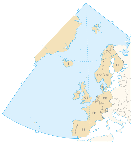
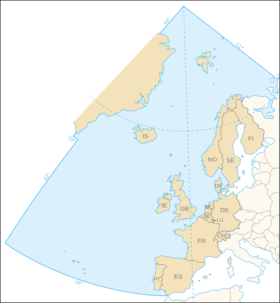
English: Map of the marine area and the 15 contracting parties of the OSPAR Commission for the protection of the marine environment of the North-East Atlantic.
Français : Carte de la zone maritime et des 15 pays signataires de la Commission OSPAR pour la protection du milieu marin de l'Atlantique du nord-est. |
||
| Datum | |||
| Quelle | Own work, based upon the map (corrected following the article 1 of the 1992 OSPAR Convention) available on the OSPAR Commission's site | ||
| Urheber | Eric Gaba (Sting - fr:Sting) | ||
| Genehmigung (Weiternutzung dieser Datei) |
|
Lizenz
Ich, der Urheber dieses Werkes, veröffentliche es unter der folgenden Lizenz:
Diese Datei ist unter der Creative-Commons-Lizenz „Namensnennung – Weitergabe unter gleichen Bedingungen 2.5 generisch“ (US-amerikanisch) lizenziert.
- Dieses Werk darf von dir
- verbreitet werden – vervielfältigt, verbreitet und öffentlich zugänglich gemacht werden
- neu zusammengestellt werden – abgewandelt und bearbeitet werden
- Zu den folgenden Bedingungen:
- Namensnennung – Du musst angemessene Urheber- und Rechteangaben machen, einen Link zur Lizenz beifügen und angeben, ob Änderungen vorgenommen wurden. Diese Angaben dürfen in jeder angemessenen Art und Weise gemacht werden, allerdings nicht so, dass der Eindruck entsteht, der Lizenzgeber unterstütze gerade dich oder deine Nutzung besonders.
- Weitergabe unter gleichen Bedingungen – Wenn du das Material wiedermischst, transformierst oder darauf aufbaust, musst du deine Beiträge unter der gleichen oder einer kompatiblen Lizenz wie das Original verbreiten.
Dateiversionen
Klicke auf einen Zeitpunkt, um diese Version zu laden.
| Version vom | Vorschaubild | Maße | Benutzer | Kommentar | |
|---|---|---|---|---|---|
| aktuell | 23:44, 9. Nov. 2006 | | 740 × 800 (202 KB) | Sting | White background |
| 23:31, 9. Nov. 2006 |  | 740 × 800 (202 KB) | Sting | {{Information| |Description=Map of the marine area and the 15 contracting parties of the OSPAR Commission for the protection of the marine environment of the North-East Atlantic |Source=Own work, based upon [http://www.ospar.org/eng/html/welcome.html the |
Dateiverwendung
Die folgende Seite verwendet diese Datei:
Globale Dateiverwendung
Die nachfolgenden anderen Wikis verwenden diese Datei:
- Verwendung auf ast.wikipedia.org
- Verwendung auf ca.wikipedia.org
- Verwendung auf cs.wikipedia.org
- Verwendung auf da.wikipedia.org
- Verwendung auf de.wiktionary.org
- Verwendung auf en.wikipedia.org
- Verwendung auf es.wikipedia.org
- Verwendung auf fr.wikipedia.org
- Verwendung auf gl.wikipedia.org
- Verwendung auf nl.wikipedia.org
- Verwendung auf no.wikipedia.org
- Verwendung auf pt.wikipedia.org
- Verwendung auf sk.wikipedia.org
- Verwendung auf sv.wikipedia.org