Datei:Nasa satellite photo side by side 2007-10-22.jpg
Originaldatei (1.050 × 410 Pixel, Dateigröße: 75 KB, MIME-Typ: image/jpeg)
![]()
Diese Datei und die Informationen unter dem roten Trennstrich werden aus dem zentralen Medienarchiv Wikimedia Commons eingebunden.
![]()
Beschreibung
| Beschreibung |
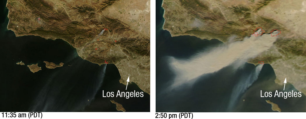
Powerful Santa Ana winds have fueled more than 10 large wildfires throughout Southern California, stretching from Santa Barbara to San Diego. This pair of images, depicting the area around Los Angeles on October 21, 2007, shows just how quickly the fires grew. The left image, captured by NASA’s Terra satellite at 11:35 a.m. local time, shows several fires giving off small plumes of smoke. Just over 3 hours later, at 2:50 p.m. when NASA’s Aqua satellite passed overhead, large amounts of smoke were pouring from blazes northwest of Los Angeles. Actively burning fires are outlined in red. In the right image plumes of smoke can be seen blowing off the coast, indicating the intensity of the winds and the presence of additional fires farther south. According to the National Interagency Fire Center, these blazes have burned over 84,000 acres since they began over the weekend. Thousands of residents have been evacuated from their homes and a state of emergency has been issued for 7 California counties. |
| Datum | |
| Quelle | Nasa |
| Urheber | NASA/MODIS Rapid Response. Story credit: Laura Spector, NASA Goddard Space Flight Center. |
Lizenz
| Diese Datei ist gemeinfrei (public domain), da sie von der NASA erstellt worden ist. Die NASA-Urheberrechtsrichtlinie besagt, dass „NASA-Material nicht durch Urheberrecht geschützt ist, wenn es nicht anders angegeben ist“. (NASA-Urheberrechtsrichtlinie-Seite oder JPL Image Use Policy). | ||
 |
Warnung:
|
Dateiversionen
Klicke auf einen Zeitpunkt, um diese Version zu laden.
| Version vom | Vorschaubild | Maße | Benutzer | Kommentar | |
|---|---|---|---|---|---|
| aktuell | 23:29, 23. Okt. 2007 | 1.050 × 410 (75 KB) | Tom | higher res | |
| 05:51, 23. Okt. 2007 | 520 × 203 (24 KB) | Johntex~commonswiki | {{Information |Description=Powerful Santa Ana winds have fueled more than 10 large wildfires throughout Southern California, stretching from Santa Barbara to San Diego. This pair of images, depicting the area around Los Angeles on October 21, 2007, shows |
Dateiverwendung
Die folgende Seite verwendet diese Datei:
Globale Dateiverwendung
Die nachfolgenden anderen Wikis verwenden diese Datei:
- Verwendung auf ar.wikipedia.org
- Verwendung auf en.wikipedia.org
- Verwendung auf en.wikinews.org
- Verwendung auf es.wikinews.org
- Verwendung auf pl.wikinews.org
- Verwendung auf simple.wikipedia.org
- Verwendung auf sv.wikipedia.org
- Verwendung auf zh.wikipedia.org