Datei:Metrolinamap.png
Es ist keine höhere Auflösung vorhanden.
Metrolinamap.png (350 × 137 Pixel, Dateigröße: 42 KB, MIME-Typ: image/png)
![]()
Diese Datei und die Informationen unter dem roten Trennstrich werden aus dem zentralen Medienarchiv Wikimedia Commons eingebunden.
![]()
Beschreibung
| Beschreibung |
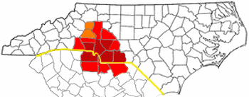
CSA and MSA of the Metrolina area. Adapted from Wikipedia's NC county maps by Seth Ilys. |
| Datum | 25. April 2006 (Original-Hochladedatum) |
| Quelle | Die Autorenschaft wurde nicht in einer maschinell lesbaren Form angegeben. Es wird angenommen, dass es sich um ein eigenes Werk handelt (basierend auf den Rechteinhaber-Angaben). |
| Urheber | Die Autorenschaft wurde nicht in einer maschinell lesbaren Form angegeben. Es wird Gooday.1~commonswiki als Autor angenommen (basierend auf den Rechteinhaber-Angaben). |
Lizenz
| Ich, der Urheberrechtsinhaber dieses Werkes, veröffentliche es als gemeinfrei. Dies gilt weltweit. In manchen Staaten könnte dies rechtlich nicht möglich sein. Sofern dies der Fall ist: Ich gewähre jedem das bedingungslose Recht, dieses Werk für jedweden Zweck zu nutzen, es sei denn, Bedingungen sind gesetzlich erforderlich. |
Dateiversionen
Klicke auf einen Zeitpunkt, um diese Version zu laden.
| Version vom | Vorschaubild | Maße | Benutzer | Kommentar | |
|---|---|---|---|---|---|
| aktuell | 06:21, 29. Dez. 2006 | 350 × 137 (42 KB) | Gooday.1~commonswiki | CSA and MSA and Charlotte USA of the Metrolina area. Adapted from Wikipedia's NC county maps by Seth Ilys. | |
| 06:12, 22. Okt. 2006 | 350 × 137 (47 KB) | Gooday.1~commonswiki | More asthetically pleasing map of the Charlotte metro area (Metrolina). Red is the most commonly accepted Metrolina area. Orange shows areas sometimes included. MSA and CSA have been left out due to their conflicting representation and overlying other reg | ||
| 05:50, 25. Apr. 2006 | 300 × 117 (34 KB) | Gooday.1~commonswiki | CSA and MSA of the Metrolina area. Adapted from Wikipedia's NC county maps by Seth Ilys. |
Dateiverwendung
Die folgende Seite verwendet diese Datei:
Globale Dateiverwendung
Die nachfolgenden anderen Wikis verwenden diese Datei:
- Verwendung auf en.wikipedia.org
- User talk:BobbyAFC
- User talk:SQFreak
- User talk:Blackcats
- User talk:Jdb1972
- User talk:Wikipedianinthehouse
- User talk:Fife Club
- User talk:Shizane
- User talk:Grinning Fool
- User talk:Aegreen
- User talk:Baseball Bugs/Archive002
- Wikipedia:WikiProject Charlotte
- User talk:Toa Nidhiki05/Archive 5
- Wikipedia:WikiProject Charlotte/welcome
- User talk:Washuotaku/Archive 2012
- Verwendung auf es.wikipedia.org
- Verwendung auf fr.wikipedia.org
- Verwendung auf it.wikivoyage.org
- Verwendung auf pl.wikipedia.org
- Verwendung auf ur.wikipedia.org
- Verwendung auf www.wikidata.org