Datei:Meghalaya COVID-19.svg

Größe der PNG-Vorschau dieser SVG-Datei: 800 × 430 Pixel. Weitere aus SVG automatisch erzeugte PNG-Grafiken in verschiedenen Auflösungen: 320 × 172 Pixel | 640 × 344 Pixel | 1.024 × 551 Pixel | 1.280 × 688 Pixel | 2.560 × 1.377 Pixel | 807 × 434 Pixel
Originaldatei (SVG-Datei, Basisgröße: 807 × 434 Pixel, Dateigröße: 157 KB)
![]()
Diese Datei und die Informationen unter dem roten Trennstrich werden aus dem zentralen Medienarchiv Wikimedia Commons eingebunden.
![]()
Beschreibung
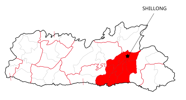
| Beschreibung | This file shows the districts of Meghalaya affected by COVID-19. |
| Datum | |
| Quelle | Meghalaya 2012.svg |
| Urheber | Nilabh |
| Andere Versionen |
[]
|


Lizenz
Ich, der Urheberrechtsinhaber dieses Werkes, veröffentliche es hiermit unter der folgenden Lizenz:
Diese Datei ist lizenziert unter der Creative-Commons-Lizenz „Namensnennung – Weitergabe unter gleichen Bedingungen 4.0 international“.
- Dieses Werk darf von dir
- verbreitet werden – vervielfältigt, verbreitet und öffentlich zugänglich gemacht werden
- neu zusammengestellt werden – abgewandelt und bearbeitet werden
- Zu den folgenden Bedingungen:
- Namensnennung – Du musst angemessene Urheber- und Rechteangaben machen, einen Link zur Lizenz beifügen und angeben, ob Änderungen vorgenommen wurden. Diese Angaben dürfen in jeder angemessenen Art und Weise gemacht werden, allerdings nicht so, dass der Eindruck entsteht, der Lizenzgeber unterstütze gerade dich oder deine Nutzung besonders.
- Weitergabe unter gleichen Bedingungen – Wenn du das Material wiedermischst, transformierst oder darauf aufbaust, musst du deine Beiträge unter der gleichen oder einer kompatiblen Lizenz wie das Original verbreiten.

|
Es ist erlaubt, die Datei unter den Bedingungen der GNU-Lizenz für freie Dokumentation, Version 1.2 oder einer späteren Version, veröffentlicht von der Free Software Foundation, zu kopieren, zu verbreiten und/oder zu modifizieren; es gibt keine unveränderlichen Abschnitte, keinen vorderen und keinen hinteren Umschlagtext.
Der vollständige Text der Lizenz ist im Kapitel GNU-Lizenz für freie Dokumentation verfügbar. |
Du darfst es unter einer der obigen Lizenzen deiner Wahl verwenden.
Dateiversionen
Klicke auf einen Zeitpunkt, um diese Version zu laden.
| Version vom | Vorschaubild | Maße | Benutzer | Kommentar | |
|---|---|---|---|---|---|
| aktuell | 14:41, 13. Mai 2020 | | 807 × 434 (157 KB) | Nilabh Shivam 333 | {{Information |description={{en|1=Districts with confirmed cases in the state of meghalaya, '''as of 12 May 2020'''.}} {{legend|#FF6347|10+ confirmed cases reported}} [https://web.archive.org/web/20040606141014/www.censusindia.net/results/2001maps/assam01.html]. Note: * This map does not show the newer districts that were created after 2014. * The new districts are Chirag, Baksa, Odalguri and Kamrup Metropolitan |Source={{Derived from|Meghalaya 2012.svg|display=50}} |Date=2020-05-13 18:34 (U... |
| 20:31, 4. Apr. 2020 |  | 631 × 530 (348 KB) | Firos ak | == {{int:filedesc}} == {{Information |Description={{en|1=This file shows the districts of en:Assam as of 2001. The map is based on a free hand trace of [https://web.archive.org/web/20040606141014/www.censusindia.net/results/2001maps/assam01.html]. Note: * This map does not show the newer districts that were created after 2001. * The new districts are Chirag, Baksa, Odalguri and Kamrup Metropolitan}} |Source={{Derived from|Assam-districts-2001.svg|display=50}} |Date=2020-04-04 18:31 (UT... | |
| 01:27, 20. Aug. 2011 |  | 631 × 530 (211 KB) | Chaipau | Corrected the following districts: Nalbari, Barpeta, Sivasagar, Tinsukia | |
| 13:02, 5. Apr. 2009 |  | 631 × 530 (165 KB) | Chaipau | The image is cropped to exclude empty spaces. | |
| 03:14, 5. Apr. 2009 |  | 744 × 1.052 (165 KB) | Chaipau | {{Information |Description={{en|1=This file shows the districts of en:Assam as of 2001. The map is based on a free hand trace of [http://web.archive.org/web/20040606141014/www.censusindia.net/results/2001maps/assam01.html]. Note: * This map does not |
Dateiverwendung
Keine Seiten verwenden diese Datei.
Globale Dateiverwendung
Die nachfolgenden anderen Wikis verwenden diese Datei:
- Verwendung auf awa.wikipedia.org
- Verwendung auf ca.wikipedia.org
- Verwendung auf eu.wikipedia.org
- Verwendung auf kk.wikipedia.org
- Verwendung auf mai.wikipedia.org
- Verwendung auf pnb.wikipedia.org
- ضلع ٹنسوکیا
- ضلع سبساگر
- ضلع ڈبروگڑھ
- ضلع دھیماجی
- ضلع جورہٹ
- ضلع لکھیمپور
- ضلع گولاگھٹ
- ضلع سونیتپور
- ضلع کربی انگلونگ
- ضلع ناگون
- ضلع ماریگون
- ضلع درنگ
- ضلع کمرپ
- ضلع نلباری
- ضلع بارپیٹا
- ضلع بونگائیگان
- ضلع گولپاڑا
- ضلع کوکراجھر
- ضلع ڈھبری
- ضلع ڈیما ہساو
- ضلع کاچڑ
- ضلع ہائیلاکنڈی
- ضلع کریم گنج
- ضلع کمرپ میٹروپولیٹن
- ضلع بکسا
- ضلع اڈلگری
- ضلع چیرنگ
- Verwendung auf ru.wikipedia.org
Weitere globale Verwendungen dieser Datei anschauen.