Originaldatei(2.180 × 1.244 Pixel, Dateigröße: 2,33 MB, MIME-Typ: image/jpeg)

Diese Datei und die Informationen unter dem roten Trennstrich werden aus dem zentralen Medienarchiv Wikimedia Commons eingebunden.

Zur Beschreibungsseite auf Commons


Beschreibung

Beschreibung
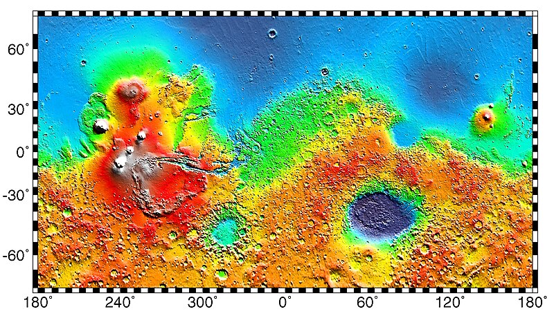
English: PIA02031: Maps of Mars Global Topography - Maps of Mars' global topography. The projections are Mercator to 70° latitude and stereographic at the poles with the south pole at left and north pole at right. Note the elevation difference between the northern and southern hemispheres. The Tharsis volcano-tectonic province is centered near the equator in the longitude range 220° E to 300° E and contains the vast east-west trending Valles Marineris canyon system and several major volcanic shields including Olympus Mons (18° N, 225° E), Alba Patera (42° N, 252° E), Ascraeus Mons (12° N, 248° E), Pavonis Mons (0°, 247° E), and Arsia Mons (9° S, 239° E). Regions and structures discussed in the text include Solis Planum (25° S, 270° E), Lunae Planum (10° N, 290° E), and Claritas Fossae (30° S, 255° E). Major impact basins include Hellas (45° S, 70° E), Argyre (50° S, 320° E), Isidis (12° N, 88° E), and Utopia (45° N, 110° E). This analysis uses an areocentric coordinate convention with east longitude positive.

Color coding on this map of the planet Mars indicates relative elevations based on data from the Mars Orbiter Laser Altimeter on NASA's Mars Global Surveyor. Red is higher elevation (up to +8 km and higher); yellow is 0 km; blue is lower elevation (down to -8 km). In longitude, the map extends from 70 degrees (north) to minus 70 degrees (south). The east-west axis is labeled at the bottom in degrees of east longitude, with the zero meridian at the center.

Data was produced by the Mars Global Surveyor's MOLA instrument

  • Producer ID: P50409 MRPS95009
Português: Mapa de Marte.
Русский: Карта Марса.
Datum (released)
Quelle http://photojournal.jpl.nasa.gov/catalog/PIA02031 (image link)
Urheber NASA/JPL/GSFC
Genehmigung
(Weiternutzung dieser Datei)
https://www.jpl.nasa.gov/imagepolicy/
Andere Versionen

Related Templates:

Related Images:

Diese Mediendatei wurde vom Jet Propulsion Lab der US-amerikanischen National Aeronautics and Space Administration (NASA) unter der Datei-ID PIA02031 kategorisiert.

Diese Markierung zeigt nicht den Urheberrechtsstatus des zugehörigen Werks an. Es ist in jedem Falle zusätzlich eine normale Lizenzvorlage erforderlich. Siehe Commons:Lizenzen für weitere Informationen.
Sprachen:

Lizenz

Public domain Diese Datei ist gemeinfrei (public domain), da sie von der NASA erstellt worden ist. Die NASA-Urheberrechtsrichtlinie besagt, dass „NASA-Material nicht durch Urheberrecht geschützt ist, wenn es nicht anders angegeben ist“. (NASA-Urheberrechtsrichtlinie-Seite oder JPL Image Use Policy).
Warnung:

Ursprüngliches Datei-Logbuch

Die ursprüngliche Dateibeschreibungsseite war hier. Alle folgenden Benutzernamen beziehen sich auf en.wikipedia.
  • 2012-10-26 05:43 Kelvin Case 613×350× (142399 bytes) {{Information |Description= {{en|Map of mars.}} {{pt|Mapa de Marte.}} http://photojournal.jpl.nasa.gov/catalog/PIA02031 PIA02031: Maps of Mars Global Topography Target Name:Mars Is a satellite of:Sol (our sun) Mission: Mars Global Surveyor (MGS) ...

Kurzbeschreibungen

Ergänze eine einzeilige Erklärung, was diese Datei darstellt.

In dieser Datei abgebildete Objekte

Motiv

Dateiversionen

Klicke auf einen Zeitpunkt, um diese Version zu laden.

Version vomVorschaubildMaßeBenutzerKommentar
aktuell04:57, 4. Mai 2019Vorschaubild der Version vom 04:57, 4. Mai 20192.180 × 1.244 (2,33 MB)HuntsterFull resolution from NASA/JPL.
11:23, 6. Mai 2014Vorschaubild der Version vom 11:23, 6. Mai 2014613 × 350 (139 KB)Wikiuser13Transferred from en.wikipedia

Keine Seiten verwenden diese Datei.

Globale Dateiverwendung

Metadaten