Datei:Map of the National Roads of South Africa with labels.svg

Größe der PNG-Vorschau dieser SVG-Datei: 684 × 599 Pixel. Weitere aus SVG automatisch erzeugte PNG-Grafiken in verschiedenen Auflösungen: 274 × 240 Pixel | 548 × 480 Pixel | 876 × 768 Pixel | 1.168 × 1.024 Pixel | 2.337 × 2.048 Pixel | 809 × 709 Pixel
Originaldatei (SVG-Datei, Basisgröße: 809 × 709 Pixel, Dateigröße: 547 KB)
![]()
Diese Datei und die Informationen unter dem roten Trennstrich werden aus dem zentralen Medienarchiv Wikimedia Commons eingebunden.
![]()
Beschreibung
| Beschreibung |
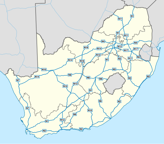
English: Map of South Africa showing the roads of the National Route System, with labels. |
| Datum | |
| Quelle | Geodata from OpenStreetMap |
| Urheber | Htonl |
| Andere Versionen | File:Map of the National Roads of South Africa.svg, File:Map of the National Roads of South Africa with labels and cities.svg |
| SVG‑Erstellung |
Lizenz
Diese Datei ist unter der Creative-Commons-Lizenz „Namensnennung – Weitergabe unter gleichen Bedingungen 3.0 nicht portiert“ lizenziert.
- Dieses Werk darf von dir
- verbreitet werden – vervielfältigt, verbreitet und öffentlich zugänglich gemacht werden
- neu zusammengestellt werden – abgewandelt und bearbeitet werden
- Zu den folgenden Bedingungen:
- Namensnennung – Du musst angemessene Urheber- und Rechteangaben machen, einen Link zur Lizenz beifügen und angeben, ob Änderungen vorgenommen wurden. Diese Angaben dürfen in jeder angemessenen Art und Weise gemacht werden, allerdings nicht so, dass der Eindruck entsteht, der Lizenzgeber unterstütze gerade dich oder deine Nutzung besonders.
- Weitergabe unter gleichen Bedingungen – Wenn du das Material wiedermischst, transformierst oder darauf aufbaust, musst du deine Beiträge unter der gleichen oder einer kompatiblen Lizenz wie das Original verbreiten.
| Dieses Werk enthält Informationen aus OpenStreetMap, die unter den Bedingungen der Open Database License (ODbL) bereitgestellt wurden.
Die ODbL erfordert keine bestimmte Lizenz für die Karten, die aus ODbL-Daten erstellt werden. Die durch die OpenStreetMap-Stiftung erstellte Kartenteile standen vor dem 1. August 2020 unter der CC-BY-SA-2.0-Lizenz. Karten von anderen Erstellern können unter anderen Lizenzen veröffentlicht sein. |
Dateiversionen
Klicke auf einen Zeitpunkt, um diese Version zu laden.
| Version vom | Vorschaubild | Maße | Benutzer | Kommentar | |
|---|---|---|---|---|---|
| aktuell | 20:45, 1. Feb. 2014 | | 809 × 709 (547 KB) | Htonl | update w/ simpler labels, roads in neighbouring countries, ODbL data |
| 21:51, 10. Dez. 2010 |  | 757 × 660 (1,08 MB) | Htonl | use appropriate projection; change basemap style | |
| 05:19, 21. Apr. 2010 |  | 1.000 × 786 (1,5 MB) | Htonl | minor SVG tweak | |
| 05:11, 21. Apr. 2010 |  | 1.000 × 786 (1,5 MB) | Htonl | new version based on OSM data | |
| 23:26, 23. Jul. 2009 |  | 1.000 × 786 (2,14 MB) | Htonl | minor tweaks | |
| 22:25, 23. Jul. 2009 |  | 1.000 × 786 (2,13 MB) | Htonl | colours, labels, widths | |
| 20:05, 6. Nov. 2008 |  | 1.000 × 786 (2,08 MB) | Htonl | {{Information |Description={{en|1=Map of South Africa showing the roads of the National Road System, with labels.}} |Source=Own work by uploader |Author=Htonl |Date=2008-11-06 |Permission= |other_versions=[[:Image:Map of the National Roads |
Dateiverwendung
Die folgende Seite verwendet diese Datei:
Globale Dateiverwendung
Die nachfolgenden anderen Wikis verwenden diese Datei:
- Verwendung auf af.wikipedia.org
- Verwendung auf en.wikipedia.org
- Verwendung auf en.wikivoyage.org
- Verwendung auf fr.wikipedia.org
- Verwendung auf fy.wikipedia.org
- Verwendung auf it.wikipedia.org
- Verwendung auf ja.wikipedia.org
- Verwendung auf nl.wikipedia.org
- Verwendung auf ro.wikipedia.org
- Verwendung auf uk.wikipedia.org
- Verwendung auf zu.wikipedia.org