Datei:Map of New York highlighting Schenectady County.svg

Größe der PNG-Vorschau dieser SVG-Datei: 787 × 600 Pixel. Weitere aus SVG automatisch erzeugte PNG-Grafiken in verschiedenen Auflösungen: 315 × 240 Pixel | 630 × 480 Pixel | 1.008 × 768 Pixel | 1.280 × 976 Pixel | 2.560 × 1.951 Pixel | 6.599 × 5.030 Pixel
Originaldatei (SVG-Datei, Basisgröße: 6.599 × 5.030 Pixel, Dateigröße: 112 KB)
![]()
Diese Datei und die Informationen unter dem roten Trennstrich werden aus dem zentralen Medienarchiv Wikimedia Commons eingebunden.
![]()
Beschreibung
| Beschreibung |
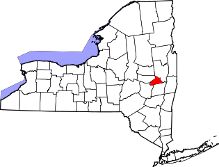
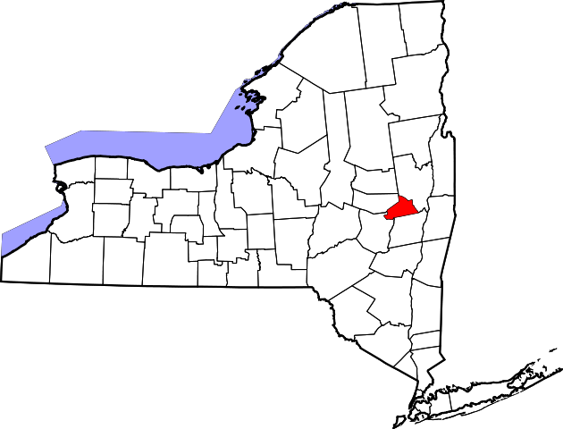
English: This is a locator map showing Schenectady County in New York. For more information, see Commons:United States county locator maps. |
| Datum | |
| Quelle |
Eigenes Werk: English: The maps use data from nationalatlas.gov, specifically countyp020.tar.gz on the Raw Data Download page. The maps also use state outline data from statesp020.tar.gz. The Florida maps use hydrogm020.tar.gz to display Lake Okeechobee. |
| Urheber | David Benbennick |
Lizenz
| Ich, der Urheberrechtsinhaber dieses Werkes, veröffentliche es als gemeinfrei. Dies gilt weltweit. In manchen Staaten könnte dies rechtlich nicht möglich sein. Sofern dies der Fall ist: Ich gewähre jedem das bedingungslose Recht, dieses Werk für jedweden Zweck zu nutzen, es sei denn, Bedingungen sind gesetzlich erforderlich. |
Dateiversionen
Klicke auf einen Zeitpunkt, um diese Version zu laden.
| Version vom | Vorschaubild | Maße | Benutzer | Kommentar | |
|---|---|---|---|---|---|
| aktuell | 17:34, 12. Feb. 2006 | | 6.599 × 5.030 (112 KB) | David Benbennick | {{subst:User:Dbenbenn/clm|county=Schenectady County|state=New York|type=county}} |
Dateiverwendung
Die folgende Seite verwendet diese Datei:
Globale Dateiverwendung
Die nachfolgenden anderen Wikis verwenden diese Datei:
- Verwendung auf ar.wikipedia.org
- Verwendung auf bg.wikipedia.org
- Verwendung auf bpy.wikipedia.org
- Verwendung auf ca.wikipedia.org
- Verwendung auf cdo.wikipedia.org
- Verwendung auf ceb.wikipedia.org
- Verwendung auf ce.wikipedia.org
- Verwendung auf cs.wikipedia.org
- Verwendung auf cy.wikipedia.org
- Verwendung auf en.wikipedia.org
- Schenectady, New York
- Schenectady County, New York
- List of counties in New York
- Delanson, New York
- Duane Lake, New York
- East Glenville, New York
- Glenville, New York
- Mariaville Lake, New York
- Pattersonville-Rotterdam Junction, New York
- Princetown, New York
- Scotia, New York
- Duanesburg (CDP), New York
- Duanesburg, New York
- Niskayuna (CDP), New York
- Niskayuna, New York
- Rotterdam (CDP), New York
- Rotterdam, New York
- Alplaus, New York
- Template:Schenectady County, New York
- National Register of Historic Places listings in Schenectady County, New York
Weitere globale Verwendungen dieser Datei anschauen.