Datei:Los Alamos aerial view.jpeg

Originaldatei (1.435 × 1.153 Pixel, Dateigröße: 757 KB, MIME-Typ: image/jpeg)
![]()
Diese Datei und die Informationen unter dem roten Trennstrich werden aus dem zentralen Medienarchiv Wikimedia Commons eingebunden.
![]()
Beschreibung
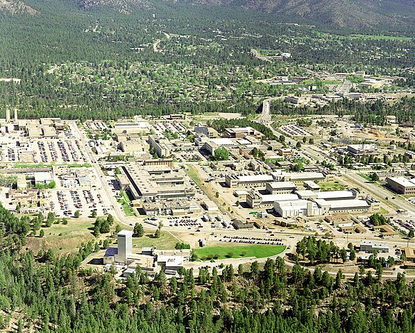
| Beschreibung | Aerial view of Los Alamos National Laboratory, "1995 aerial TA-3 south to north". |
| Quelle | http://www.lanl.gov/worldview/news/photos/aerials.shtml |
| Urheber | Los Alamos National Laboratory |
| Objektposition | | Dieses und weitere Bilder auf OpenStreetMap |
|---|
|
Dieses Bild zeigt ein Objekt, das im National Register of Historic Places der Vereinigten Staaten verzeichnet ist. Die Referenznummer lautet 66000893. |

|
In diesem Bild waren Hinweise auf den Urheber, wie z. B. der Name, die E-Mail-Adresse oder Webseite enthalten. Diese Informationen wurden aus dem Bild entfernt und in die Meta-Daten bzw. die Bildbschreibungsseite übernommen. Dies erleichtert die Weiternutzung des Bildes, vermeidet Probleme bei der Verwendung unterschiedlicher Sprachen und vereinfacht die Suche. Wikimedia Commons rät davon ab, sichtbare Informationen über den Urheber in Bilder zu plazieren.
|
Lizenz

|
This image comes from Los Alamos National Laboratory, a national laboratory privately operated under contract from the United States Department of Energy by Los Alamos National Security, LLC between October 1, 2007 and October 31, 2018. LANL allowed anyone to use it for any purpose, provided that the copyright holder is properly attributed. Redistribution, derivative work, commercial use, and all other use is permitted. LANL requires the following text be used when crediting images to it: (link)
Unless otherwise indicated, this information has been authored by an employee or employees of the Los Alamos National Security, LLC (LANS), operator of the Los Alamos National Laboratory under Contract No. DE-AC52-06NA25396 with the U.S. Department of Energy. The U.S. Government has rights to use, reproduce, and distribute this information. The public may copy and use this information without charge, provided that this Notice and any statement of authorship are reproduced on all copies. Neither the Government nor LANS makes any warranty, express or implied, or assumes any liability or responsibility for the use of this information. |
|
Dateiversionen
Klicke auf einen Zeitpunkt, um diese Version zu laden.
| Version vom | Vorschaubild | Maße | Benutzer | Kommentar | |
|---|---|---|---|---|---|
| aktuell | 16:22, 26. Jun. 2011 | | 1.435 × 1.153 (757 KB) | Keraunoscopia | removed watermark |
| 11:18, 8. Mai 2005 |  | 1.435 × 1.153 (750 KB) | Floriang | Aerial view of Los Alamos National Laboratory, "1995 aerial TA-3 south to north", from http://www.lanl.gov/worldview/news/photos/aerials.shtml ''Source:'' en.wikipedia.org, upload by Fastfission {{PD-USGov}} [[Category:Bi |
Dateiverwendung
Die folgenden 3 Seiten verwenden diese Datei:
Globale Dateiverwendung
Die nachfolgenden anderen Wikis verwenden diese Datei:
- Verwendung auf ar.wikipedia.org
- Verwendung auf bg.wikipedia.org
- Verwendung auf bn.wikipedia.org
- Verwendung auf bo.wikipedia.org
- Verwendung auf br.wikipedia.org
- Verwendung auf ca.wikipedia.org
- Verwendung auf cs.wikipedia.org
- Verwendung auf da.wikipedia.org
- Verwendung auf el.wikipedia.org
- Verwendung auf en.wikipedia.org
- Fermi paradox
- Los Alamos National Laboratory
- Theodore Hall
- Bechtel
- Albuquerque–Santa Fe–Los Alamos combined statistical area
- List of National Historic Landmarks in New Mexico
- National Register of Historic Places listings in Los Alamos County, New Mexico
- User:CM at Bechtel/Major projects table
- Draft:Triad National Security
- Verwendung auf en.wikiversity.org
- Verwendung auf eo.wikipedia.org
- Verwendung auf es.wikipedia.org
- Verwendung auf et.wikipedia.org
- Verwendung auf eu.wikipedia.org
- Verwendung auf fa.wikipedia.org
- Verwendung auf fi.wikipedia.org
- Verwendung auf fr.wikipedia.org
- Verwendung auf gl.wikipedia.org
- Verwendung auf ha.wikipedia.org
- Verwendung auf he.wikipedia.org
- Verwendung auf hy.wikipedia.org
Weitere globale Verwendungen dieser Datei anschauen.