Datei:Limited recognition.png

Größe dieser Vorschau: 800 × 400 Pixel. Weitere Auflösungen: 320 × 160 Pixel | 640 × 320 Pixel | 1.100 × 550 Pixel
Originaldatei (1.100 × 550 Pixel, Dateigröße: 20 KB, MIME-Typ: image/png)
![]()
Diese Datei und die Informationen unter dem roten Trennstrich werden aus dem zentralen Medienarchiv Wikimedia Commons eingebunden.
![]()

|
File:Limited Recognition States.svg ist eine vektorisierte Version dieses Bildes. Diese sollte an Stelle des Rasterbildes verwendet werden, sofern sie nicht schlechter ist.
File:Limited recognition.png → File:Limited Recognition States.svg
Für weitere Informationen siehe Help:SVG. |
 |
| English | |
|---|---|
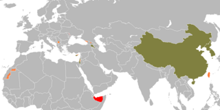
| No recognition by any state | |
| Recognized by UN non-members only | |
| UN non-members recognized by at least one UN member | |
| UN member states, not recognized by at least one other state | |
| UN member states, recognized by all other states | |
| Beschreibung |
Nederlands: Lijst van niet of gedeeltelijk erkende staten
中文(简体):未被普遍承认的国家地图
中文(繁體):未被普遍承認的國家地圖
This is a map of states that meet the inclusion criteria at en:List_of_states_with_limited_recognition#Criteria_for_inclusion. Importantly, only states which "satisfy the en:declarative theory of statehood" or which are "recognised as a state by at least one en:UN member state" are included. |
| Datum | (UTC) |
| Quelle | |
| Urheber |
|
| Andere Versionen |
 |
| Dieses Bild wurde digital nachbearbeitet. Folgende Änderungen wurden vorgenommen: regroup the states per en:List of states with limited ecognition. Das Originalbild kann hier eingesehen werden: Recognition problems Barry Kent.png:
|
| This map is ineligible for copyright and therefore in the public domain, because it consists entirely of information that is common property and contains no original authorship. For more information, see Commons:Threshold of originality § Maps.
|
Ursprüngliches Datei-Logbuch
This image is a derivative work of the following images:
- File:Recognition_problems_Barry_Kent.png licensed with Cc-by-2.5, Cc-by-sa-3.0-migrated, GFDL
- 2010-02-03T14:04:22Z EmilJ 1248x661 (33.636 Bytes) fix collateral damage
- 2010-02-03T11:33:38Z EmilJ 1248x661 (33.668 Bytes) adjust Somaliland/Puntland boundary
- 2009-12-29T14:46:47Z EmilJ 1248x661 (37.111 Bytes) Liechtenstein and Slovakia normalized relations
- 2009-12-08T17:48:16Z EmilJ 1248x661 (33.669 Bytes) fix colour of Cyprus
- 2009-09-07T11:47:13Z EmilJ 1248x661 (33.704 Bytes) add Armenia, per [[:en:List of states with limited recognition]]
- 2009-07-13T14:42:14Z EmilJ 1248x661 (33.690 Bytes) Liechtenstein recognized the Czech Rep.
- 2009-07-08T13:56:41Z EmilJ 1248x661 (33.739 Bytes) correct the position of Liechtenstein, enlarge it to make it visible
- 2008-08-26T12:41:24Z Soman 1248x661 (57.342 Bytes) change abkhazia and s ossetia to pink, as Russia has now recognized those states. Change Kosovo border to same style as other pink areas.
- 2008-08-10T17:18:13Z IJA 1248x661 (57.422 Bytes) added North Korea, South Korea, Czech Republic, Slovak Republic and Liechtenstein
- 2008-04-15T18:29:14Z Barry Kent 1248x661 (57.299 Bytes) {| align=center width="800px" style="width:800px; vertical-align:top; border:1px solid #abd5f5; background-color:#f1f5fc;" ![[English]] |- | {{legend|#FF0000|No international recognition}} {{legend|#FF8484|Limited recognitio
- 2008-04-13T10:11:39Z Happenstance 1248x661 (33.754 Bytes) +liechtenstein (not rec by CR, Slovakia)
- 2008-03-19T19:22:04Z Barry Kent 1248x661 (57.292 Bytes) {| align=center width="800px" style="width:800px; vertical-align:top; border:1px solid #abd5f5; background-color:#f1f5fc;" ![[English]] |- | {{legend|#FF0000|No international recognition}} {{legend|#FF8484|Limited recognitio
Hochgeladen mit derivativeFX
Dateiversionen
Klicke auf einen Zeitpunkt, um diese Version zu laden.
| Version vom | Vorschaubild | Maße | Benutzer | Kommentar | |
|---|---|---|---|---|---|
| aktuell | 23:32, 6. Jan. 2024 | | 1.100 × 550 (20 KB) | Iktsokh | Azerbaijan has regained de facto control over its internationally recognized territory (Republic of Artsakh completely ceases to exist from January 1, 2024). |
| 12:07, 4. Nov. 2023 |  | 1.100 × 550 (20 KB) | Siirski | Reverted to version as of 05:37, 8 October 2022 (UTC) | |
| 20:27, 1. Okt. 2023 |  | 1.100 × 550 (37 KB) | Caawiyahaderon | https://www.thehindu.com/news/international/pro-somalia-militia-takes-key-army-base-in-breakaway-region/article67238670.ece | |
| 07:37, 8. Okt. 2022 |  | 1.100 × 550 (20 KB) | Spesh531 | Removing Donetsk and Luhansk | |
| 05:13, 5. Jul. 2022 |  | 1.100 × 550 (20 KB) | Chipmunkdavis | Reverted to version as of 07:31, 28 February 2022 (UTC) Evidence is unclear | |
| 04:29, 5. Jul. 2022 |  | 1.100 × 550 (20 KB) | Yue | Updated per request at en:Talk:List of states with limited recognition#Somaliland. | |
| 09:31, 28. Feb. 2022 |  | 1.100 × 550 (20 KB) | Spesh531 | Reverted to version as of 03:58, 23 February 2022 (UTC) New image does not match color scheme, and is very sloppily done | |
| 07:20, 28. Feb. 2022 |  | 1.100 × 550 (33 KB) | ㅇㅡㅇ | New Photo | |
| 05:58, 23. Feb. 2022 |  | 1.100 × 550 (20 KB) | Spesh531 | Restoring original size | |
| 22:09, 21. Feb. 2022 |  | 800 × 400 (42 KB) | Nicolay Sidorov | Russia recognized independence of the Donetsk Rep. and the Lugansk Rep. |
Dateiverwendung
Keine Seiten verwenden diese Datei.
Globale Dateiverwendung
Die nachfolgenden anderen Wikis verwenden diese Datei:
- Verwendung auf af.wikipedia.org
- Verwendung auf an.wikipedia.org
- Verwendung auf ar.wikipedia.org
- Verwendung auf ary.wikipedia.org
- Verwendung auf arz.wikipedia.org
- Verwendung auf be.wikipedia.org
- Verwendung auf cy.wikipedia.org
- Verwendung auf el.wikipedia.org
- Verwendung auf en.wikipedia.org
- Verwendung auf eo.wikipedia.org
- Verwendung auf fi.wikipedia.org
- Verwendung auf fr.wikipedia.org
- Verwendung auf gl.wikipedia.org
- Verwendung auf hr.wikipedia.org
- Verwendung auf hu.wikipedia.org
- Verwendung auf hy.wikipedia.org
- Verwendung auf id.wikipedia.org
- Verwendung auf it.wikipedia.org
- Verwendung auf ka.wikipedia.org
- Verwendung auf li.wikipedia.org
- Verwendung auf lv.wikipedia.org
- Verwendung auf mk.wikipedia.org
- Verwendung auf nl.wikipedia.org
- Verwendung auf pl.wikipedia.org
- Verwendung auf ps.wikipedia.org
- Verwendung auf pt.wikipedia.org
- Verwendung auf sh.wikipedia.org
- Verwendung auf sr.wikipedia.org
- Verwendung auf ur.wikipedia.org
- Verwendung auf vi.wikipedia.org
- Verwendung auf xmf.wikipedia.org