Datei:Langlois and Van Gogh bridges locations map.gif
Es ist keine höhere Auflösung vorhanden.
Langlois_and_Van_Gogh_bridges_locations_map.gif (300 × 482 Pixel, Dateigröße: 20 KB, MIME-Typ: image/gif)
![]()
Diese Datei und die Informationen unter dem roten Trennstrich werden aus dem zentralen Medienarchiv Wikimedia Commons eingebunden.
![]()
| Beschreibung |
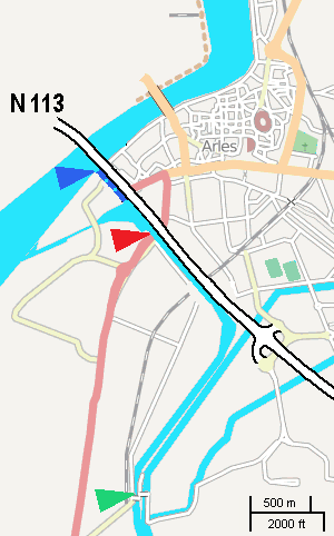
English: This rough map, adapted from a screenshot from OSM, shows locations of Langlois bridge (red) and today's Van Gogh bridge (green). Dark blue shows the channel entrance as of 1888. |
| Datum | |
| Quelle | self, using a screenshot from OpenSourceMaps |
| Urheber | user:W. |
| Genehmigung (Weiternutzung dieser Datei) |
Diese Datei ist unter der Creative-Commons-Lizenz „Namensnennung – Weitergabe unter gleichen Bedingungen 2.0 generisch“ (US-amerikanisch) lizenziert.
|
Dateiversionen
Klicke auf einen Zeitpunkt, um diese Version zu laden.
| Version vom | Vorschaubild | Maße | Benutzer | Kommentar | |
|---|---|---|---|---|---|
| aktuell | 11:56, 5. Nov. 2008 | | 300 × 482 (20 KB) | W. | {{Information |Description= |Source= |Date= |Author= |Permission= |other_versions= }} |
| 14:07, 4. Nov. 2008 |  | 300 × 482 (20 KB) | W. | {{Information |Description={{en|1=This rough map, adapted from a screenshot from OSM, shows locations of ''Langlois bridge'' (red) and today's ''Van Gogh bridge'' (green). Dark blue shows the channel entrance as of 1888.}} |Source=self, using a screenshot |
Dateiverwendung
Die folgende Seite verwendet diese Datei:
Globale Dateiverwendung
Die nachfolgenden anderen Wikis verwenden diese Datei:
- Verwendung auf en.wikipedia.org
- Verwendung auf eo.wikipedia.org
- Verwendung auf fr.wikipedia.org