Datei:Korean Peninsula ESA21108299.jpeg

Originaldatei (2.944 × 3.058 Pixel, Dateigröße: 5,98 MB, MIME-Typ: image/jpeg)
![]()
Diese Datei und die Informationen unter dem roten Trennstrich werden aus dem zentralen Medienarchiv Wikimedia Commons eingebunden.
![]()
Beschreibung
| Beschreibung |
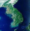
English: The Korean Peninsula in East Asia can be seen in this image captured by the Copernicus Sentinel-3 mission. The peninsula is over 900 km long and is located between the Sea of Japan, also known as the East Sea, to the east and the Yellow Sea to the west. The peninsula is divided into two countries – the Democratic People's Republic of Korea (North Korea) and the Republic of Korea (South Korea). North Korea is divided into nine provinces, with Pyongyang as the capital. Pyongyang, which can be seen in light grey in the upper left of the image, lies on the banks of the Taedong River and on a flat plain about 50 km inland from the Korea Bay. The capital of South Korea is Seoul, which is in the northwest of the country, slightly inland and around 50 km south of the North Korean border. As the image shows, the Korean peninsula is mostly mountainous and rocky, making less than 20% of the land suitable for farming. The Yellow Sea owes its name to the silt-laden waters from the Chinese rivers that empty into it. It is also one of the largest shallow areas of continental shelf in the world with an average depth of around 50 m. The waters off the coast of Korea are considered among the best in the world for fishing. The warm and cold currents attract a wide variety of species and the numerous islands, inlets and reefs provide excellent fishing grounds. Sentinel-3 is a two-satellite mission to supply the coverage and data delivery needed for Europe’s Copernicus environmental monitoring programme. Each satellite’s instrument package includes an optical sensor to monitor changes in the colour of Earth’s surfaces. It can be used, for example, to monitor ocean biology and water quality. This image, which was captured on 21 May 2019, is also featured on the Earth from Space video programme. |
| Datum | 18. Oktober 2019 (Hochladedatum) |
| Quelle | Korean Peninsula |
| Urheber | European Space Agency |
| Andere Versionen |
|
| Activity | Observing the Earth |
| Mission | Sentinel-3 |
| Set | Earth observation image of the week |
| System | Copernicus |
Lizenz

|
This image contains data from a satellite in the Copernicus Programme, such as Sentinel-1, Sentinel-2 or Sentinel-3. Attribution is required when using this image.
Namensnennung: Contains modified Copernicus Sentinel data 2019
The use of Copernicus Sentinel Data is regulated under EU law (Commission Delegated Regulation (EU) No 1159/2013 and Regulation (EU) No 377/2014). Relevant excerpts:
Free access shall be given to GMES dedicated data [...] made available through GMES dissemination platforms [...].
Access to GMES dedicated data [...] shall be given for the purpose of the following use in so far as it is lawful:
GMES dedicated data [...] may be used worldwide without limitations in time.
GMES dedicated data and GMES service information are provided to users without any express or implied warranty, including as regards quality and suitability for any purpose. |
This media was created by the European Space Agency (ESA).
Where expressly so stated, images or videos are covered by the Creative Commons Attribution-ShareAlike 3.0 IGO (CC BY-SA 3.0 IGO) licence, ESA being an Intergovernmental Organisation (IGO), as defined by the CC BY-SA 3.0 IGO licence. The user is allowed under the terms and conditions of the CC BY-SA 3.0 IGO license to Reproduce, Distribute and Publicly Perform the ESA images and videos released under CC BY-SA 3.0 IGO licence and the Adaptations thereof, without further explicit permission being necessary, for as long as the user complies with the conditions and restrictions set forth in the CC BY-SA 3.0 IGO licence, these including that:
See the ESA Creative Commons copyright notice for complete information, and this article for additional details.
|
 | |
Diese Datei ist lizenziert unter der Creative-Commons-Lizenz „Namensnennung – Weitergabe unter gleichen Bedingungen 3.0 IGO“. Namensnennung: ESA, CC BY-SA IGO 3.0
| ||
Dateiversionen
Klicke auf einen Zeitpunkt, um diese Version zu laden.
| Version vom | Vorschaubild | Maße | Benutzer | Kommentar | |
|---|---|---|---|---|---|
| aktuell | 15:04, 7. Jun. 2020 | | 2.944 × 3.058 (5,98 MB) | OptimusPrimeBot | #Spacemedia - Upload of https://www.esa.int/var/esa/storage/images/esa_multimedia/images/2019/10/korean_peninsula/21108288-1-eng-GB/Korean_Peninsula.jpg via Commons:Spacemedia |
Dateiverwendung
Die folgende Seite verwendet diese Datei:
Globale Dateiverwendung
Die nachfolgenden anderen Wikis verwenden diese Datei:
- Verwendung auf www.wikidata.org