Datei:Jupiter Cylindrical Map - Dec 2000 PIA07782.jpg

Originaldatei (3.601 × 1.801 Pixel, Dateigröße: 431 KB, MIME-Typ: image/jpeg)
![]()
Diese Datei und die Informationen unter dem roten Trennstrich werden aus dem zentralen Medienarchiv Wikimedia Commons eingebunden.
![]()
Beschreibung
| Beschreibung |
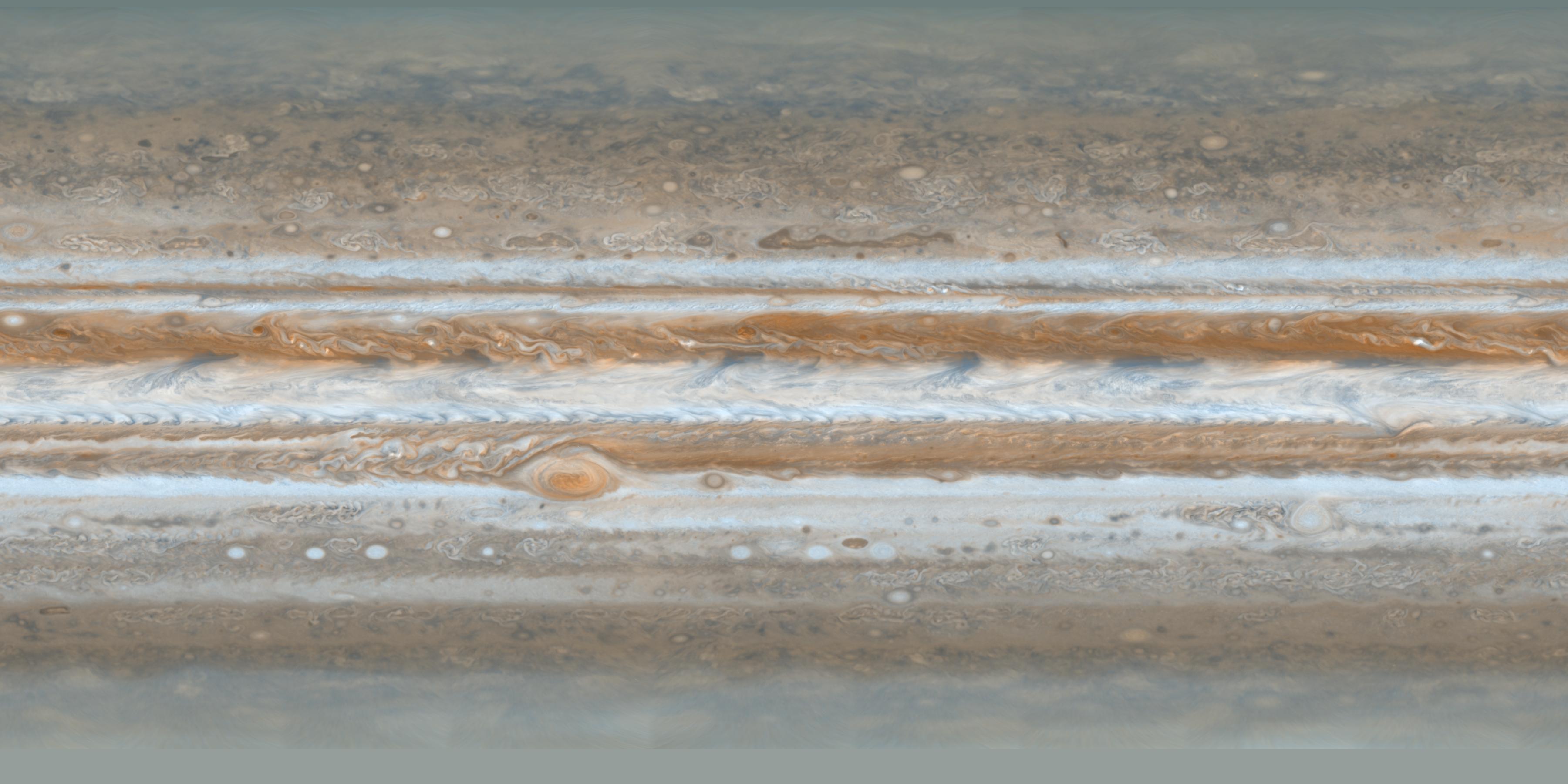
English: PIA07782: Cassini's Best Maps of Jupiter (Cylindrical Map) - These color maps of Jupiter were constructed from images taken by the narrow-angle camera onboard NASA's Cassini spacecraft on Dec. 11 and 12, 2000, as the spacecraft neared Jupiter during its flyby of the giant planet. Cassini was on its way to Saturn. They are the most detailed global color maps of Jupiter ever produced. The smallest visible features are about 120 kilometers (75 miles) across.
The maps are composed of 36 images: a pair of images covering Jupiter's northern and southern hemispheres was acquired in two colors every hour for nine hours as Jupiter rotated beneath the spacecraft. Although the raw images are in just two colors, 750 nanometers (near-infrared) and 451 nanometers (blue), the map's colors are close to those the human eye would see when gazing at Jupiter. The maps show a variety of colorful cloud features, including parallel reddish-brown and white bands, the Great Red Spot, multi-lobed chaotic regions, white ovals and many small vortices. Many clouds appear in streaks and waves due to continual stretching and folding by Jupiter's winds and turbulence. The bluish-gray features along the north edge of the central bright band are equatorial "hot spots," meteorological systems such as the one entered by NASA's Galileo probe. Small bright spots within the orange band north of the equator are lightning-bearing thunderstorms. The polar regions are less clearly visible because Cassini viewed them at an angle and through thicker atmospheric haze (such as the whitish material in the south polar map -- see PIA07784. Pixels in the rectangular map cover equal increments of planetocentric latitude (which is measured relative to the center of the planet) and longitude, and extend to 180 degrees of latitude and 360 degrees of longitude. |
| Datum | |
| Quelle | http://photojournal.jpl.nasa.gov/catalog/PIA07782 (image link) |
| Urheber | NASA/JPL/Space Science Institute |
Diese Mediendatei wurde vom Jet Propulsion Lab der US-amerikanischen National Aeronautics and Space Administration (NASA) unter der Datei-ID PIA07782 kategorisiert. Diese Markierung zeigt nicht den Urheberrechtsstatus des zugehörigen Werks an. Es ist in jedem Falle zusätzlich eine normale Lizenzvorlage erforderlich. Siehe Commons:Lizenzen für weitere Informationen. Sprachen:
|
Lizenz
| Diese Datei ist gemeinfrei (public domain), da sie von der NASA erstellt worden ist. Die NASA-Urheberrechtsrichtlinie besagt, dass „NASA-Material nicht durch Urheberrecht geschützt ist, wenn es nicht anders angegeben ist“. (NASA-Urheberrechtsrichtlinie-Seite oder JPL Image Use Policy). | ||
 |
Warnung:
|
Dateiversionen
Klicke auf einen Zeitpunkt, um diese Version zu laden.
| Version vom | Vorschaubild | Maße | Benutzer | Kommentar | |
|---|---|---|---|---|---|
| aktuell | 00:58, 26. Jan. 2011 | | 3.601 × 1.801 (431 KB) | Spischot | {{Information |Description ={{en|1=Constructed from images taken by the narrow-angle camera onboard NASA's Cassini spacecraft on Dec. 11 and 12, 2000, as the spacecraft neared Jupiter during its flyby. Pixels in the rectangular map cover equal incremen |
Dateiverwendung
Die folgenden 3 Seiten verwenden diese Datei:
Globale Dateiverwendung
Die nachfolgenden anderen Wikis verwenden diese Datei:
- Verwendung auf fr.wikipedia.org
- Verwendung auf pl.wikipedia.org
- Verwendung auf ru.wikipedia.org