Datei:Jangmi 2008-09-27 0445Z.jpg

Größe dieser Vorschau: 473 × 599 Pixel. Weitere Auflösungen: 189 × 240 Pixel | 379 × 480 Pixel | 606 × 768 Pixel | 808 × 1.024 Pixel | 1.617 × 2.048 Pixel | 6.000 × 7.600 Pixel
Originaldatei (6.000 × 7.600 Pixel, Dateigröße: 4,93 MB, MIME-Typ: image/jpeg)
![]()
Diese Datei und die Informationen unter dem roten Trennstrich werden aus dem zentralen Medienarchiv Wikimedia Commons eingebunden.
![]()
Beschreibung
| Beschreibung |
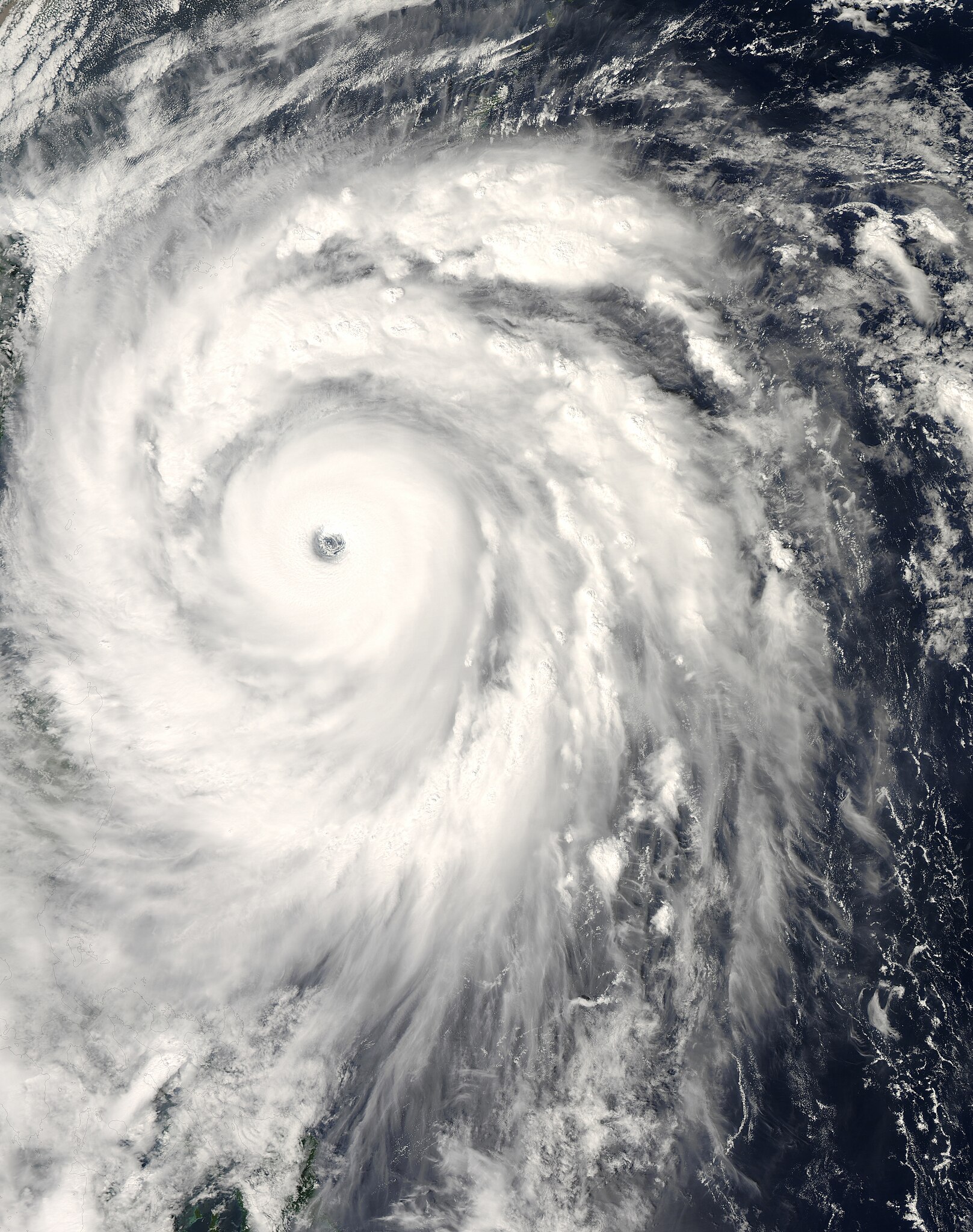
English: The title of “strongest storm of 2008” goes to Typhoon Jangmi, shown in this image from the Moderate Resolution Imaging Spectroradiometer (MODIS) on NASA’s Aqua satellite from September 27, 2008.
Seen from space, even a super typhoon seems more beautiful than dangerous. The 50-kilometer-wide eye of Jangmi is encircled by a smooth disk of clouds. Bands of clouds swirl gracefully into the low-pressure heart of the storm. The smooth cloud band north of the eye is studded with thunderstorms. On the ground, Jangmi was less lovely It was not only the strongest storm in any ocean basin in 2008 but the only storm to reach category 5 strength anywhere in the world that year. |
| Datum | |
| Quelle | http://rapidfire.sci.gsfc.nasa.gov/cgi-bin/imagery/single.cgi?image=Jangmi.A2008271.0445.250m.jpg |
| Urheber | MODIS image captured by NASA’s Aqua satellite |
| Kameraposition | | Dieses und weitere Bilder auf OpenStreetMap |
|---|
Lizenz
| Diese Datei ist gemeinfrei (public domain), da sie von der NASA erstellt worden ist. Die NASA-Urheberrechtsrichtlinie besagt, dass „NASA-Material nicht durch Urheberrecht geschützt ist, wenn es nicht anders angegeben ist“. (NASA-Urheberrechtsrichtlinie-Seite oder JPL Image Use Policy). | ||
 |
Warnung:
|
Dateiversionen
Klicke auf einen Zeitpunkt, um diese Version zu laden.
| Version vom | Vorschaubild | Maße | Benutzer | Kommentar | |
|---|---|---|---|---|---|
| aktuell | 15:58, 30. Mai 2018 | | 6.000 × 7.600 (4,93 MB) | Nino Marakot | Reverted to version as of 05:09, 9 January 2018 (UTC) |
| 01:03, 22. Apr. 2018 |  | 1.723 × 2.089 (1,06 MB) | Saxitoxin | Less gray | |
| 01:02, 22. Apr. 2018 |  | 1.723 × 2.089 (2,64 MB) | Saxitoxin | More storm centered | |
| 07:09, 9. Jan. 2018 |  | 6.000 × 7.600 (4,93 MB) | Nino Marakot | Reverted to version as of 22:20, 2 November 2008 (UTC) - It's gallery version. Please separate them (it would become 3rd party if stayed) | |
| 17:48, 24. Nov. 2017 |  | 5.985 × 7.980 (9,62 MB) | Meow | Rebuilt. | |
| 00:20, 3. Nov. 2008 |  | 6.000 × 7.600 (4,93 MB) | Cyclonebiskit | {{Information |Description={{en|1={{en|1=Satellite image of Typhoon Jangmi at 0445 UTC Sept. 27, 2008.}}This photo-like image was taken by the Aqua MODIS Satellite as Typhoon Jangmi (or Super Typhoon 19W according to the JTWC) moved closer to the island o |
Dateiverwendung
Die folgende Seite verwendet diese Datei:
Globale Dateiverwendung
Die nachfolgenden anderen Wikis verwenden diese Datei:
- Verwendung auf en.wikipedia.org
- Verwendung auf ja.wikipedia.org
- Verwendung auf ko.wikipedia.org
- Verwendung auf pt.wikipedia.org
- Verwendung auf vi.wikipedia.org
- Verwendung auf zh-yue.wikipedia.org
- Verwendung auf zh.wikipedia.org