Datei:Israeli-Palestinian Railways.svg

Originaldatei (SVG-Datei, Basisgröße: 1.660 × 2.748 Pixel, Dateigröße: 592 KB)
![]()
Diese Datei und die Informationen unter dem roten Trennstrich werden aus dem zentralen Medienarchiv Wikimedia Commons eingebunden.
![]()
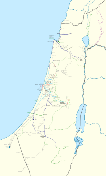
Beschreibung
| Beschreibung |
Français : Carte des chemins de fer Israéliens/Palestiniens.
English: This map shows all railways that have been operated by Palestine Railways, Israel Railways, or have existed on the territory of Israel/Palestine.
Certain sources show more train stations at:
I could not find a secondary source, and so they have been left out. There might also have been a Haifa-Wadi Rushmiya line. The station at Birein was probably more of a simple water refilling stop; this is possibly the same for other former stops in the Negev. The J'slm - El Bireh line was a military railway built by the British in 1918 to supply the war front North of Jerusalem. Very little information is available on it, and so its path is very hypothetical; this is also true for other lines (mostly in the Negev). Names: I tried to put former names where possible (space permitting). A plethora of translations, transliterations, and transcriptions exist when romanising Hebrew and Arabic station names. Since this map is in English, I have preferred the name that appeared the most "English" in my eyes. For clarity, a hyphen "-" is used to separate the town name from a qualifier. Borders: Undisputed borders 1949 Green line 1974 Purple line East Jerusalem municipal borders
Train Lines: Open (electrified) Open Open (freight only) Being built Closed |
| Datum | |
| Quelle |
|
| Urheber | Mapeh |
| Andere Versionen |
A bigger version of this map exists: Israeli-Palestinian Railways (Full).svg. The source code for both is exactly the same: the only differences between the two are the boundaries (this map has smaller boundaries, therefore "cutting off" the empty parts: the Negev, the Sinai, and the Mediterranean), and which layers are visible (this map shows a schematic version of the Sinai Railway, while the full map shows a geographically accurate version). |
.svg)
Lizenz
- Dieses Werk darf von dir
- verbreitet werden – vervielfältigt, verbreitet und öffentlich zugänglich gemacht werden
- neu zusammengestellt werden – abgewandelt und bearbeitet werden
- Zu den folgenden Bedingungen:
- Namensnennung – Du musst angemessene Urheber- und Rechteangaben machen, einen Link zur Lizenz beifügen und angeben, ob Änderungen vorgenommen wurden. Diese Angaben dürfen in jeder angemessenen Art und Weise gemacht werden, allerdings nicht so, dass der Eindruck entsteht, der Lizenzgeber unterstütze gerade dich oder deine Nutzung besonders.
- Weitergabe unter gleichen Bedingungen – Wenn du das Material wiedermischst, transformierst oder darauf aufbaust, musst du deine Beiträge unter der gleichen oder einer kompatiblen Lizenz wie das Original verbreiten.
Dateiversionen
Klicke auf einen Zeitpunkt, um diese Version zu laden.
| Version vom | Vorschaubild | Maße | Benutzer | Kommentar | |
|---|---|---|---|---|---|
| aktuell | 22:33, 16. Sep. 2023 | | 1.660 × 2.748 (592 KB) | Crash48 | Eastern Railway being rebuilt: https://www.jpost.com/business-and-innovation/article-738891 |
| 08:22, 23. Aug. 2023 |  | 1.660 × 2.748 (592 KB) | Crash48 | +names of Bnei Brak – Ramat HaHayal (Tel Aviv – North) | |
| 10:39, 22. Aug. 2023 |  | 1.660 × 2.748 (591 KB) | Crash48 | Netanya-Lod-Ashkelon electrified | |
| 21:48, 21. Aug. 2023 |  | 1.660 × 2.748 (591 KB) | Crash48 | +Dor/Tantura, Zikhron Yaakov, Jaffa Docks | |
| 00:26, 19. Aug. 2023 |  | 1.660 × 2.748 (588 KB) | Crash48 | +Red LRT lines | |
| 12:20, 4. Jun. 2022 |  | 1.660 × 2.748 (567 KB) | Glide08 | Updated to mark the Herzliya-Sharon-Ashkelon and Jerusalem-Modi'in electrified lines | |
| 01:05, 4. Nov. 2021 |  | 1.660 × 2.748 (566 KB) | Glide08 | Updated to mark electrified lines as a separate color, and reflect on the extension of the Sharon Railway to Herzliya and the closure of the Beit Shemesh-Malha railway. | |
| 19:41, 2. Mai 2020 |  | 1.660 × 2.748 (574 KB) | Mapeh | Minor: fixed color of Mazkeret Batya station label | |
| 20:43, 17. Mär. 2020 |  | 1.660 × 2.748 (551 KB) | Mapeh | Corrected the color of Mazkeret Batya station | |
| 16:32, 18. Aug. 2019 |  | 1.660 × 2.748 (574 KB) | My another account | 1) w:Mazkeret Batya railway station opened on 30/05/2019; 2) Change font for Nahariya to mark it as terminus; 3) Wilhelma was a separate station from Rantiya; 4) Tzrifin and Tel HaShomer stations were out of use by the time these settlements got their modern names. |
Dateiverwendung
Die folgenden 2 Seiten verwenden diese Datei:
Globale Dateiverwendung
Die nachfolgenden anderen Wikis verwenden diese Datei:
- Verwendung auf ar.wikipedia.org
- Verwendung auf en.wikipedia.org
- Verwendung auf he.wikipedia.org
- Verwendung auf hu.wikipedia.org
- Verwendung auf ru.wikipedia.org
- Verwendung auf www.wikidata.org