Datei:ISS029-E-008032 Fires along the Rio Xingu - Brazil.jpg

Originaldatei (4.288 × 2.848 Pixel, Dateigröße: 8,76 MB, MIME-Typ: image/jpeg)
![]()
Diese Datei und die Informationen unter dem roten Trennstrich werden aus dem zentralen Medienarchiv Wikimedia Commons eingebunden.
![]()
Beschreibung
| Beschreibung |
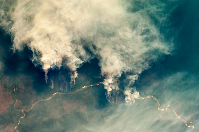
English: Slash-and-burn forest clearing along the Rio Xingu (Xingu River) in the state of Mato Grosso, Brazil.
|
||||||||||||||||||||||||||||||||||||||||||||||||||||||
| Datum | |||||||||||||||||||||||||||||||||||||||||||||||||||||||
| Quelle | ISS029-E-8032 | ||||||||||||||||||||||||||||||||||||||||||||||||||||||
| Urheber |
|
||||||||||||||||||||||||||||||||||||||||||||||||||||||
| Andere Versionen |
|
||||||||||||||||||||||||||||||||||||||||||||||||||||||


Diese Datei ist gemeinfrei (public domain), da sie vom Image Science & Analysis Laboratory der NASA erstellt worden ist. Die NASA-Urheberrechtsrichtlinie besagt, dass „NASA-Material nicht durch Urheberrecht geschützt ist, wenn es nicht anders angegeben ist“ (NASA-Urheberrechtsrichtlinien-Seite oder Nutzungsbedingungen für Fotos von Astronauten). Die Aufnahme ist Teil der Reihe The Gateway to Astronaut Photography of Earth. Bildquelle: ISS029-E-008032.
|
Lizenz
| Diese Datei ist gemeinfrei (public domain), da sie von der NASA erstellt worden ist. Die NASA-Urheberrechtsrichtlinie besagt, dass „NASA-Material nicht durch Urheberrecht geschützt ist, wenn es nicht anders angegeben ist“. (NASA-Urheberrechtsrichtlinie-Seite oder JPL Image Use Policy). | ||
 |
Warnung:
|
Dateiversionen
Klicke auf einen Zeitpunkt, um diese Version zu laden.
| Version vom | Vorschaubild | Maße | Benutzer | Kommentar | |
|---|---|---|---|---|---|
| aktuell | 11:55, 27. Apr. 2013 | | 4.288 × 2.848 (8,76 MB) | Julian Herzog | User created page with UploadWizard |
Dateiverwendung
Die folgende Seite verwendet diese Datei:
Globale Dateiverwendung
Die nachfolgenden anderen Wikis verwenden diese Datei:
- Verwendung auf af.wikipedia.org
- Verwendung auf ar.wikipedia.org
- Verwendung auf cs.wikipedia.org
- Verwendung auf dag.wikipedia.org
- Verwendung auf en.wikipedia.org
- Verwendung auf ga.wikipedia.org
- Verwendung auf ha.wikipedia.org
- Verwendung auf ig.wikipedia.org
- Verwendung auf ja.wikipedia.org
- Verwendung auf ml.wikipedia.org
- Verwendung auf mni.wikipedia.org
- Verwendung auf mr.wikipedia.org
- Verwendung auf ms.wikipedia.org
- Verwendung auf pa.wikipedia.org
- Verwendung auf shi.wikipedia.org
- Verwendung auf simple.wikipedia.org
- Verwendung auf sv.wikipedia.org
- Verwendung auf zh.wikipedia.org