Datei:Divisiones administrativas de la Confederación Perú-Boliviana.svg

Größe der PNG-Vorschau dieser SVG-Datei: 514 × 599 Pixel. Weitere aus SVG automatisch erzeugte PNG-Grafiken in verschiedenen Auflösungen: 206 × 240 Pixel | 412 × 480 Pixel | 659 × 768 Pixel | 878 × 1.024 Pixel | 1.757 × 2.048 Pixel | 1.230 × 1.434 Pixel
Originaldatei (SVG-Datei, Basisgröße: 1.230 × 1.434 Pixel, Dateigröße: 844 KB)
![]()
Diese Datei und die Informationen unter dem roten Trennstrich werden aus dem zentralen Medienarchiv Wikimedia Commons eingebunden.
![]()
Beschreibung
| Beschreibung |
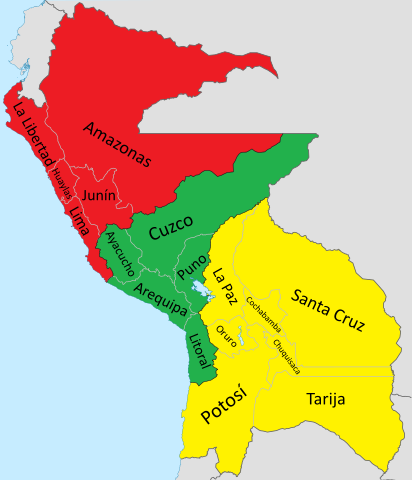
Español: Mapa de la Confederación Perú-Boliviana. Incluye todos los territorios en disputa (Límite con Ecuador, Colombia y Brasil en el Amazonas, el Corredor de Atacama con Chile, el Chaco con Paraguay y Tarija con Argentina, además de la Puna de Atacama).
English: Map of the Peru-Bolivian Confederation. It includes all the disputed territories (The border with Ecuador, Colombia and Brazil in the Amazon, the Atacama Corridor with Chile, the Chacho with Paraguay and Tarija with Argentina, in addition to the Puna de Atacama). |
| Datum | |
| Quelle |
Eigenes Werk Coastline extracted from: File:Ecuador location map.svg & File:Chile location map.svg by NordNordWest & File:Peru location map.svg by Spischot |
| Urheber |
Janitoalevic Coastline extracted from: File:Ecuador location map.svg & File:Chile location map.svg by NordNordWest & File:Peru location map.svg by Spischot |
| Andere Versionen | File:Divisiones administrativas de la Confederación Perú-Boliviana.svg |
Lizenz

|
Es ist erlaubt, die Datei unter den Bedingungen der GNU-Lizenz für freie Dokumentation, Version 1.2 oder einer späteren Version, veröffentlicht von der Free Software Foundation, zu kopieren, zu verbreiten und/oder zu modifizieren; es gibt keine unveränderlichen Abschnitte, keinen vorderen und keinen hinteren Umschlagtext.
Der vollständige Text der Lizenz ist im Kapitel GNU-Lizenz für freie Dokumentation verfügbar. |
Dateiversionen
Klicke auf einen Zeitpunkt, um diese Version zu laden.
| Version vom | Vorschaubild | Maße | Benutzer | Kommentar | |
|---|---|---|---|---|---|
| aktuell | 04:39, 22. Jul. 2020 | | 1.230 × 1.434 (844 KB) | Janitoalevic | Detalles |
| 04:19, 22. Jul. 2020 |  | 1.230 × 1.434 (862 KB) | Janitoalevic | + Huaylas & Oruro. * Límites mejorados. | |
| 02:24, 1. Dez. 2019 |  | 1.230 × 1.434 (817 KB) | Janitoalevic | . | |
| 02:20, 1. Dez. 2019 |  | 1.230 × 1.434 (816 KB) | Janitoalevic | Added Litoral and Tarija. | |
| 02:20, 1. Dez. 2019 |  | 1.230 × 1.434 (800 KB) | Janitoalevic | . | |
| 03:11, 28. Aug. 2019 |  | 1.230 × 1.434 (816 KB) | Janitoalevic | fixed coastline | |
| 02:00, 28. Aug. 2019 |  | 1.230 × 1.434 (816 KB) | Janitoalevic | User created page with UploadWizard |
Dateiverwendung
Die folgende Seite verwendet diese Datei:
Globale Dateiverwendung
Die nachfolgenden anderen Wikis verwenden diese Datei:
- Verwendung auf en.wikipedia.org
- Verwendung auf es.wikipedia.org
- Verwendung auf ja.wikipedia.org
- Verwendung auf ru.wikipedia.org
- Verwendung auf tr.wikipedia.org