Datei:Chesapeake and Delaware Canal eastern entrance.jpg

Größe dieser Vorschau: 800 × 527 Pixel. Weitere Auflösungen: 320 × 211 Pixel | 640 × 422 Pixel | 1.024 × 674 Pixel | 1.500 × 988 Pixel
Originaldatei (1.500 × 988 Pixel, Dateigröße: 527 KB, MIME-Typ: image/jpeg)
![]()
Diese Datei und die Informationen unter dem roten Trennstrich werden aus dem zentralen Medienarchiv Wikimedia Commons eingebunden.
![]()
| Beschreibung |
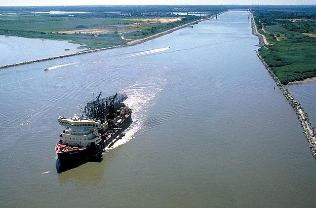
English: The eastern entrance to the Chesapeake & Delaware Canal at Reedy Point, Delaware. Fort Dupont State park is at the right. The Reedy Point Bridge, carrying Delaware State Route 9, is visible in the distance. The U.S. Army Corps of Engineers hopper dredge McFarland is exiting the channel. View is to the east. The channel entrance is located on the Delaware River in New Castle County, Delaware, USA.
|
|||
| Datum | not specified or unknown | |||
| Quelle |
U.S. Army Corps of Engineers Digital Visual Library Image page Image description page Digital Visual Library home page |
|||
| Urheber | Anthony Bley, U.S. Army Corps of Engineers | |||
| Genehmigung (Weiternutzung dieser Datei) |
|
|||
| Ort | Delaware River, New Castle County, Delaware, USA |
| Kameraposition | | Dieses und weitere Bilder auf OpenStreetMap |
|---|
Dateiversionen
Klicke auf einen Zeitpunkt, um diese Version zu laden.
| Version vom | Vorschaubild | Maße | Benutzer | Kommentar | |
|---|---|---|---|---|---|
| aktuell | 04:46, 8. Apr. 2007 | | 1.500 × 988 (527 KB) | DanMS | {{Information | Description = {{en|The eastern entrance to the Chesapeake & Delaware Canal at Reedy Point, Delaware. Fort Dupont State park is at the right. The Reedy Point Bridge, carrying Delaware State Route 9, is visible in the distance. The U. |
Dateiverwendung
Die folgende Seite verwendet diese Datei:
Globale Dateiverwendung
Die nachfolgenden anderen Wikis verwenden diese Datei:
- Verwendung auf en.wikipedia.org
- Verwendung auf es.wikipedia.org
- Verwendung auf fr.wikipedia.org
- Verwendung auf no.wikipedia.org
- Verwendung auf vi.wikipedia.org
- Verwendung auf www.wikidata.org
- Verwendung auf zh.wikipedia.org