Datei:Central Tien Shan, China.JPG

Originaldatei (4.288 × 2.850 Pixel, Dateigröße: 1,92 MB, MIME-Typ: image/jpeg)
![]()
Diese Datei und die Informationen unter dem roten Trennstrich werden aus dem zentralen Medienarchiv Wikimedia Commons eingebunden.
![]()
Beschreibung
| Beschreibung |
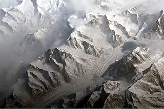
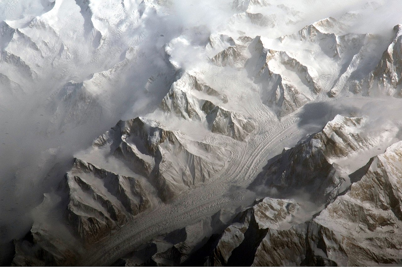
English: This astronaut photograph provides a view of the central Tien Shan, about 64 kilometres east of where the borders of China, Kyrgyzstan, and Kazakhstan meet.
While the image looks like it might have been taken from an airplane, it was taken from the International Space Station (ISS) at an altitude of 341 kilometres. The altitude plus the horizontal distance from the site—ISS was approximately 304 kilometres to the south-west—produces an oblique view. This angle, together with shadowing of valleys, accentuates the mountainous topography. Two types of glaciers are visible in the image; cirque glaciers occupy amphitheater-like depressions on the upper slopes of the mountains, and feed ice down-slope to aggregate into large valley glaciers such as the one at image centre. Low clouds obscure an adjacent valley and glaciers to the north (upper left). Two high peaks of the central Tien Shan are identifiable in the image. Xuelian Feng has a summit of 6, 527 meters above sea level. To the east, the aptly-named Peak 6231 has a summit 6,231 meters above sea level. |
| Datum | |
| Quelle | NASA Earth Observatory |
| Urheber | ISS Expedition 27 crew |
| Kameraposition | | Dieses und weitere Bilder auf OpenStreetMap |
|---|
Diese Mediendatei wurde vom Johnson Space Center der US-amerikanischen National Aeronautics and Space Administration (NASA) unter der Datei-ID ISS027-E-5274 kategorisiert. Diese Markierung zeigt nicht den Urheberrechtsstatus des zugehörigen Werks an. Es ist in jedem Falle zusätzlich eine normale Lizenzvorlage erforderlich. Siehe Commons:Lizenzen für weitere Informationen. Sprachen:
|
Image acquired with a Nikon D2Xs digital camera using an 800 mm lens, and is provided by the ISS Crew Earth Observations experiment and Image Science & Analysis Laboratory, Johnson Space Center.
Lizenz
| Diese Datei ist gemeinfrei (public domain), da sie von der NASA erstellt worden ist. Die NASA-Urheberrechtsrichtlinie besagt, dass „NASA-Material nicht durch Urheberrecht geschützt ist, wenn es nicht anders angegeben ist“. (NASA-Urheberrechtsrichtlinie-Seite oder JPL Image Use Policy). | ||
 |
Warnung:
|
| Bildnotizen | Diese Datei ist annotiert: Betrachte diese auf Commons. |
Dateiversionen
Klicke auf einen Zeitpunkt, um diese Version zu laden.
| Version vom | Vorschaubild | Maße | Benutzer | Kommentar | |
|---|---|---|---|---|---|
| aktuell | 12:58, 28. Mär. 2011 | | 4.288 × 2.850 (1,92 MB) | Originalwana | {{Information |Description ={{en|1=This astronaut photograph provides a view of the central Tien Shan, about 64 kilometres east of where the borders of China, Kyrgyzstan, and Kazakhstan meet. While the image looks like it might have been taken |
Dateiverwendung
Die folgende Seite verwendet diese Datei:
Globale Dateiverwendung
Die nachfolgenden anderen Wikis verwenden diese Datei:
- Verwendung auf ast.wikipedia.org
- Verwendung auf cs.wikipedia.org
- Verwendung auf es.wikipedia.org
- Verwendung auf fi.wikipedia.org
- Verwendung auf gl.wikipedia.org
- Verwendung auf he.wikipedia.org
- Verwendung auf hr.wikipedia.org
- Verwendung auf ml.wikipedia.org
- Verwendung auf mr.wikipedia.org
- Verwendung auf sr.wikipedia.org
- Verwendung auf ug.wikipedia.org
- Verwendung auf uk.wikipedia.org
- Verwendung auf www.wikidata.org