Datei:Bassin de l'Authie-fr.svg

Größe der PNG-Vorschau dieser SVG-Datei: 800 × 461 Pixel. Weitere aus SVG automatisch erzeugte PNG-Grafiken in verschiedenen Auflösungen: 320 × 184 Pixel | 640 × 369 Pixel | 1.024 × 590 Pixel | 1.280 × 738 Pixel | 2.560 × 1.476 Pixel | 1.060 × 611 Pixel
Originaldatei (SVG-Datei, Basisgröße: 1.060 × 611 Pixel, Dateigröße: 1,14 MB)
![]()
Diese Datei und die Informationen unter dem roten Trennstrich werden aus dem zentralen Medienarchiv Wikimedia Commons eingebunden.
![]()
| Beschreibung |
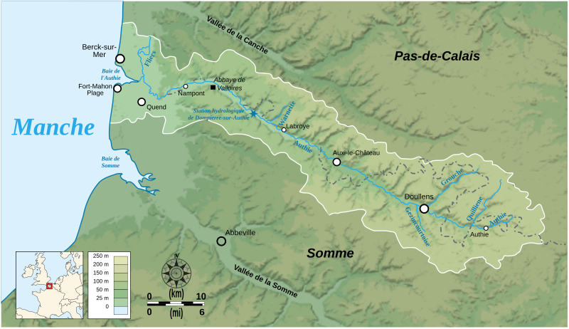
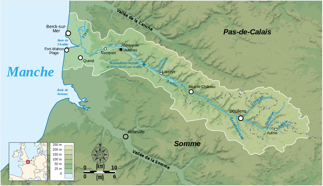
English: Map showing the drainage basin of the Authie river, Picardie, France. Français : Carte du bassin versant de l'Authie, Picardie, France. |
||
| Datum | |||
| Quelle |
Data sources:
Softwares used: Others:
|
||
| Urheber | Bourrichon | ||
| Genehmigung (Weiternutzung dieser Datei) |
Diese Datei ist unter der Creative-Commons-Lizenz „Namensnennung – Weitergabe unter gleichen Bedingungen 3.0 nicht portiert“ lizenziert.
|


|
Diese SVG-Datei enthält eingebetteten Text, der mit jedem geeigneten SVG-Editor, Texteditor oder dem SVG-Übersetzungs-Werkzeug in deine Sprache übersetzt werden kann. Für mehr Informationen siehe Über das Übersetzen von SVG-Dateien. |
Diese W3C-unbestimmte Vektorgrafik wurde mit Inkscape erstellt .
Dateiversionen
Klicke auf einen Zeitpunkt, um diese Version zu laden.
| Version vom | Vorschaubild | Maße | Benutzer | Kommentar | |
|---|---|---|---|---|---|
| aktuell | 20:54, 22. Feb. 2008 | | 1.060 × 611 (1,14 MB) | Bourrichon | correction placement Abbeville + typo |
| 19:01, 22. Feb. 2008 |  | 1.060 × 611 (1,43 MB) | Bourrichon | + taille toponymes et ajout des vallées de la Somme et de la Canche | |
| 03:37, 17. Feb. 2008 |  | 1.060 × 611 (1,44 MB) | Bourrichon | Petites corrections (typo, cadre) | |
| 03:19, 17. Feb. 2008 |  | 1.060 × 611 (1,14 MB) | Bourrichon | + incorporation correcte du bitmap dans le svg | |
| 02:07, 17. Feb. 2008 |  | 1.060 × 611 (136 KB) | Bourrichon | + incorporation du fond bitmap dans le svg | |
| 02:01, 17. Feb. 2008 |  | 1.060 × 611 (136 KB) | Bourrichon | {{Information |Description= {{en}}Map showing the drainage basin of the Authie river, between Picardie and Haute-Normandie, France. {{fr}}Carte du bassin versant de l'Authie, entre la Picardie et la Haute-Normandie, Fra |
Dateiverwendung
Die folgende Seite verwendet diese Datei:
Globale Dateiverwendung
Die nachfolgenden anderen Wikis verwenden diese Datei:
- Verwendung auf en.wikipedia.org
- Verwendung auf es.wikipedia.org
- Verwendung auf et.wikipedia.org
- Verwendung auf fr.wikipedia.org
- Verwendung auf it.wikipedia.org
- Verwendung auf nn.wikipedia.org
- Verwendung auf pcd.wikipedia.org
- Verwendung auf pl.wikipedia.org
- Verwendung auf ru.wikipedia.org
- Verwendung auf sr.wikipedia.org
- Verwendung auf www.wikidata.org
- Verwendung auf zh.wikipedia.org