Datei:AralSeaAug1964-keyhole.jpg
Größe dieser Vorschau: 600 × 599 Pixel. Weitere Auflösungen: 240 × 240 Pixel | 481 × 480 Pixel | 769 × 768 Pixel | 1.025 × 1.024 Pixel | 1.556 × 1.554 Pixel
Originaldatei (1.556 × 1.554 Pixel, Dateigröße: 1,11 MB, MIME-Typ: image/jpeg)
![]()
Diese Datei und die Informationen unter dem roten Trennstrich werden aus dem zentralen Medienarchiv Wikimedia Commons eingebunden.
![]()
Beschreibung
| Beschreibung |
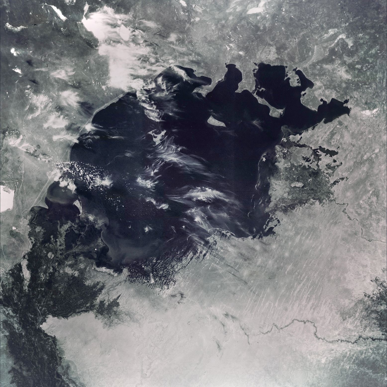
English: This image of the Aral Sea was acquired in August of 1964 by a United States Argon intelligence mapping/geodesy satellite.
KH-5 Mission 9064-A (incorrectly mislabeled 9066-A in the USGS archive) carried the A-22 mapping camera. A TAT-Agena carried this camera into an orbit of 114.96 degrees of inclination with a period of 84 minutes, a perigee of 219 degrees and an apogee of 232 degrees. International Launch Designation: 1964-043A Launch Date: August 21, 1964 Mission Duration: approximately 6 days |
| Datum | |
| Quelle | The Aral Sea, Before the Streams Ran Dry - NASA Earth Observatory |
| Urheber | Image from the U.S. Air Force KH-5 9066A reconnaissance satellite, the last of the Argon series. |
Lizenz
| Diese Datei ist gemeinfrei (public domain), da sie von der NASA erstellt worden ist. Die NASA-Urheberrechtsrichtlinie besagt, dass „NASA-Material nicht durch Urheberrecht geschützt ist, wenn es nicht anders angegeben ist“. (NASA-Urheberrechtsrichtlinie-Seite oder JPL Image Use Policy). | ||
 |
Warnung:
|
Ursprüngliches Datei-Logbuch
Die ursprüngliche Dateibeschreibungsseite war hier. Alle folgenden Benutzernamen beziehen sich auf en.wikipedia.
- 2006-07-05 05:48 Hartze11 450×450×8 (35583 bytes) This image of the Aral Sea was acquired in August of 1964 by a United States intelligence mapping satellite.
| Bildnotizen | Diese Datei ist annotiert: Betrachte diese auf Commons. |

Dateiversionen
Klicke auf einen Zeitpunkt, um diese Version zu laden.
| Version vom | Vorschaubild | Maße | Benutzer | Kommentar | |
|---|---|---|---|---|---|
| aktuell | 22:11, 30. Mai 2022 | | 1.556 × 1.554 (1,11 MB) | Italyoz484 | Fixed haze. |
| 16:56, 9. Sep. 2021 |  | 1.556 × 1.554 (1,08 MB) | LightandDark2000 | Reverted to version as of 06:33, 5 August 2021 (UTC) That looks worse. | |
| 20:21, 5. Sep. 2021 |  | 800 × 800 (105 KB) | PineappIed | more accurate depiction | |
| 20:16, 5. Sep. 2021 |  | 3.930 × 3.930 (2,9 MB) | PineappIed | ||
| 08:33, 5. Aug. 2021 |  | 1.556 × 1.554 (1,08 MB) | Italyoz484 | coloration | |
| 12:53, 1. Okt. 2014 |  | 3.930 × 3.930 (2,9 MB) | Szczureq | Full resolution found at NASA Earth Observatory (http://earthobservatory.nasa.gov/IOTD/view.php?id=77193) | |
| 00:52, 11. Jan. 2008 |  | 450 × 450 (35 KB) | File Upload Bot (Magnus Manske) | {{BotMoveToCommons|en.wikipedia}} {{Information |Description={{en|This image of the Aral Sea was acquired in August of 1964 by a United States Argon intelligence mapping/geodesy satellite. KH-5 Mission 9064-A (incorrectly mislabeled 9066-A in the USGS |
Dateiverwendung
Die folgende Seite verwendet diese Datei:
Globale Dateiverwendung
Die nachfolgenden anderen Wikis verwenden diese Datei:
- Verwendung auf ba.wikipedia.org
- Verwendung auf it.wikipedia.org
- Verwendung auf km.wikipedia.org
- Verwendung auf nn.wikipedia.org
- Verwendung auf pl.wikipedia.org
- Verwendung auf ru.wikipedia.org
- Verwendung auf ta.wikipedia.org