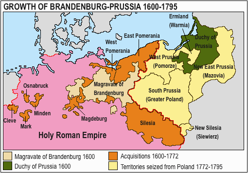
Datei:Acprussiamap2.gif
Es ist keine höhere Auflösung vorhanden.
Acprussiamap2.gif (510 × 357 Pixel, Dateigröße: 27 KB, MIME-Typ: image/gif, 0,1 s)
![]()
Diese Datei und die Informationen unter dem roten Trennstrich werden aus dem zentralen Medienarchiv Wikimedia Commons eingebunden.
![]()

This image was copied from wikipedia:pt. The original description was:
Licença GNU, fonte en:Wikipedia.

|
Es ist erlaubt, die Datei unter den Bedingungen der GNU-Lizenz für freie Dokumentation, Version 1.2 oder einer späteren Version, veröffentlicht von der Free Software Foundation, zu kopieren, zu verbreiten und/oder zu modifizieren; es gibt keine unveränderlichen Abschnitte, keinen vorderen und keinen hinteren Umschlagtext.
Der vollständige Text der Lizenz ist im Kapitel GNU-Lizenz für freie Dokumentation verfügbar. |
| Diese Datei ist unter der Creative-Commons-Lizenz „Namensnennung – Weitergabe unter gleichen Bedingungen 3.0 nicht portiert“ lizenziert. | ||
| ||
| Diese Lizenzmarkierung wurde auf Grund der GFDL-Lizenzaktualisierung hinzugefügt. |

|
This map has been uploaded by Electionworld from en.wikipedia.org to enable the |
Growth of Prussia en:Image:Ac.prussiamap2.gif

|
Dieses Bild des Typs Historical map sollte als Vektorgrafik im SVG-Format neu erstellt werden. Vektorformate haben zahlreiche Vorteile; weitere Information unter Commons:Media for cleanup. Wenn dir eine SVG-Version dieses Bildes vorliegt, so lade diese bitte hoch. Nach dem Hochladen der Datei ist diese Vorlage auf der aktuellen Bildbeschreibungsseite durch die Vorlage {{Vector version available}}, oder kürzer {{Vva}}, zu ersetzen. Es ist empfohlen die neue SVG-Datei „Acprussiamap2.svg“ zu nennen – dann benötigt die Vorlage vector version available (bzw. vva) keinen Parameter.
|
Dateiversionen
Klicke auf einen Zeitpunkt, um diese Version zu laden.
| Version vom | Vorschaubild | Maße | Benutzer | Kommentar | |
|---|---|---|---|---|---|
| aktuell | 15:17, 15. Mär. 2020 | | 510 × 357 (27 KB) | E-960 | Ermland, correction. |
| 14:50, 15. Mär. 2020 |  | 510 × 357 (27 KB) | E-960 | Names of territories and format. | |
| 21:44, 1. Jun. 2009 |  | 510 × 357 (14 KB) | Hohum | Changed colours to more cartographic, less garish. Made sea blue instead of portions of land. | |
| 20:36, 25. Aug. 2006 |  | 510 × 357 (15 KB) | LeonardoG | This image was copied from wikipedia:pt. The original description was: Licença GNU, fonte en:Wikipedia. {{GFDL}} en:Image:Ac.prussiamap2.gif {| border="1" ! date/time || username || resolution || size || edit summary |---- | |} |
Dateiverwendung
Keine Seiten verwenden diese Datei.
Globale Dateiverwendung
Die nachfolgenden anderen Wikis verwenden diese Datei:
- Verwendung auf af.wikipedia.org
- Verwendung auf ar.wikipedia.org
- Verwendung auf ast.wikipedia.org
- Verwendung auf bg.wikipedia.org
- Verwendung auf ca.wikipedia.org
- Verwendung auf cs.wikipedia.org
- Verwendung auf el.wikipedia.org
- Verwendung auf en.wikipedia.org
- History of Germany
- House of Hohenzollern
- Prussia
- Margraviate of Brandenburg
- Prussian Army
- Territorial evolution of Germany
- Subdivisions of the Polish–Lithuanian territories following the partitions
- Prussian Partition
- 18th-century history of Germany
- Brandenburg–Pomeranian conflict
- Treaty of Vossem (1673)
- User:Falcaorib
- User:JMvanDijk/Sandbox 9/Box 15/Box 3
- Verwendung auf es.wikipedia.org
- Verwendung auf et.wikipedia.org
- Verwendung auf eu.wikipedia.org
- Verwendung auf fa.wikipedia.org
- Verwendung auf fi.wikipedia.org
- Verwendung auf fr.wikipedia.org
- Verwendung auf he.wikipedia.org
- Verwendung auf hy.wikipedia.org
- Verwendung auf it.wikipedia.org
Weitere globale Verwendungen dieser Datei anschauen.