Datei:Thomas Circle - Washington, D.C..jpg

Originaldatei (5.672 × 3.944 Pixel, Dateigröße: 4,97 MB, MIME-Typ: image/jpeg)
![]()
Diese Datei und die Informationen unter dem roten Trennstrich werden aus dem zentralen Medienarchiv Wikimedia Commons eingebunden.
![]()
Beschreibung
| Beschreibung |
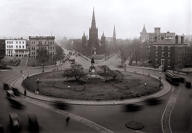
Looking north past Thomas Circle in Washington, D.C. as viewed from the Portland Flats (demolished; built in 1880 and designed by Adolf Cluss; city's first apartment building). The traffic circle is located at the junction of 14th Street (visible on the lower right and center left), Massachusetts Avenue (right and left sides), Vermont Avenue (lower left and center right), and M Street (bottom right and bottom left), NW. The equestrian statue seen in this image was erected in 1879 and honors General George Henry Thomas. The streetcar lines wrapping around the Circle on 14th Street were installed in the 1890s, but no longer exist. The homes visible on either side of the Circle have been demolished. National City Christian Church, designed by John Russell Pope in 1930, now stands on the Circle's west side and is a contributing property to the Greater Fourteenth Street Historic District. The Wylie House, seen on the right, was demolished in 1947 and replaced with the nine-story Washington Plaza Hotel designed by Morris Lapidus. The taller church seen directly across the Circle is Luther Place Memorial Church (originally known as Memorial Evangelical Lutheran Church), built in 1873 and listed on the National Register of Historic Places. A statue honoring Martin Luther is located in front of the church. It was a gift from the German emperor in 1884 and is a replica of the Martin Luther statue in Worms, Germany. Directly behind Luther Place is Mount Olivet Lutheran Church, a contributing property to the Logan Circle Historic District. The building was constructed in 1884 and originally home to the Vermont Avenue Christian Church (original name for the National City Christian Church). Mount Olivet purchased the property in 1953. The two remaining landmarks that can be seen in this image include Vermont Avenue Baptist Church (look NE on Vermont; the steeple is visible) and John Wesley AME Zion Church (look north on 14th Street; the steeple is also visible). Both buildings are contributing properties to the Greater Fourteenth Street Historic District. |
||
| Datum | |||
| Quelle |
|
||
| Urheber | National Photo Company | ||
| Andere Versionen |
Abgeleitete Werke dieser Datei: |


Lizenz
Dieses Werk ist in den Vereinigten Staaten gemeinfrei, da es von Mitarbeitern der US-amerikanischen Bundesregierung oder einem ihrer Organe in Ausübung ihrer dienstlichen Pflichten erstellt wurde und deshalb nach Titel 17, Kapitel 1, Sektion 105 des US Code ein Werk der Regierung der Vereinigten Staaten von Amerika ist.
Achtung: Dies bezieht sich nur auf originale Werke der Bundesregierung oder eines ihrer Organe, jedoch nicht auf Werke der Regierung eines Bundesstaates oder einer lokalen Behörde. Ebenfalls ausgeschlossen sind seit 1978 herausgegebene Briefmarken und bestimmte Geldmünzen.
|
 | |
| Es wurde festgestellt, dass diese Datei frei von bekannten Beschränkungen durch das Urheberrecht ist, alle verbundenen und verwandten Rechte eingeschlossen. | ||
Dateiversionen
Klicke auf einen Zeitpunkt, um diese Version zu laden.
| Version vom | Vorschaubild | Maße | Benutzer | Kommentar | |
|---|---|---|---|---|---|
| aktuell | 13:21, 5. Feb. 2009 | | 5.672 × 3.944 (4,97 MB) | APK | {{Information |Description=Looking north past Thomas Circle in Washington, D.C. as viewed from the Portland Flats (demolished; built in 1880 and designed by Adolf Cluss; city's first apartment building). The traffic circle is located at the junction of 14 |
Dateiverwendung
Keine Seiten verwenden diese Datei.
Globale Dateiverwendung
Die nachfolgenden anderen Wikis verwenden diese Datei:
- Verwendung auf ceb.wikipedia.org
- Verwendung auf en.wikipedia.org
- Verwendung auf fr.wikipedia.org
- Verwendung auf tl.wikipedia.org
- Verwendung auf www.wikidata.org