Datei:Mississippi-Coast-towns-NOAA.jpg
Mississippi-Coast-towns-NOAA.jpg (750 × 382 Pixel, Dateigröße: 57 KB, MIME-Typ: image/jpeg)
![]()
Diese Datei und die Informationen unter dem roten Trennstrich werden aus dem zentralen Medienarchiv Wikimedia Commons eingebunden.
![]()

|
Dieses Bild des Typs Map sollte als Vektorgrafik im SVG-Format neu erstellt werden. Vektorformate haben zahlreiche Vorteile; weitere Information unter Commons:Media for cleanup. Wenn dir eine SVG-Version dieses Bildes vorliegt, so lade diese bitte hoch. Nach dem Hochladen der Datei ist diese Vorlage auf der aktuellen Bildbeschreibungsseite durch die Vorlage {{Vector version available}}, oder kürzer {{Vva}}, zu ersetzen. Es ist empfohlen die neue SVG-Datei „Mississippi-Coast-towns-NOAA.svg“ zu nennen – dann benötigt die Vorlage vector version available (bzw. vva) keinen Parameter.
|


Beschreibung
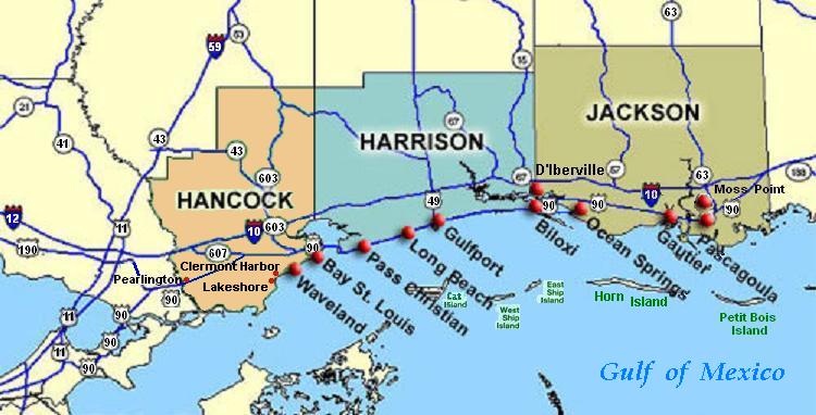
| Beschreibung | Coastal map of the U.S. state of Mississippi, showing major towns and cities in the three coastal counties: Hancock, Harrison, and Jackson County. Also shown are Cat Island, West Ship Island, East Ship Island, Horn Island and Petit Bois Island.The locations of towns, roads and offshore islands are based on NOAA and NASA maps. |
| Datum | |
| Quelle |
Eigenes Werk; self-made (hand-edited with MS-Paint)
Pure stupidity: The map is in quick JPEG format, for large display as highly readable, in about 20 articles that display the map. JPEG clarity is enhanced by painted areas behind many labels, causing the wording to be clearer than even a massive SVG or PNG-format file could provide, due to the sharp display contrast of JPEG files. JPEG Clarity: Even though JPEG images have artifacts, they can display clearer wording in small maps due to auto-contrast enhancement. The same painted/shaded areas, that illuminate wording, would make the map excessively gargantuan in slow cumbersome PNG or SVG format, as is the case with terrain maps, which also should NEVER be converted to massive PNG format. |
| Urheber | Wikid77 |
Lizenz
| Dieses Werk wurde von seinem Urheber I, Wikid77 als gemeinfrei veröffentlicht. Dies gilt weltweit. In manchen Staaten könnte dies rechtlich nicht möglich sein. Sofern dies der Fall ist: I, Wikid77 gewährt jedem das bedingungslose Recht, dieses Werk für jedweden Zweck zu nutzen, es sei denn, Bedingungen sind gesetzlich erforderlich. |
Dateiversionen
Klicke auf einen Zeitpunkt, um diese Version zu laden.
| Version vom | Vorschaubild | Maße | Benutzer | Kommentar | |
|---|---|---|---|---|---|
| aktuell | 04:54, 26. Jun. 2007 | | 750 × 382 (57 KB) | Wikid77 | Brown-toned map: Hancock County as tan (was green); put "Gulf of Mexico" Antigua font; shift labels on islands |
| 02:17, 26. Jun. 2007 |  | 750 × 382 (56 KB) | Wikid77 | Mississippi coastal map, with "Horn Island" relabeled, clarified Hwy "90" and "63" icons. | |
| 20:56, 21. Jun. 2007 |  | 750 × 382 (56 KB) | Wikid77 | re-load of image file, in case internal data was garbled | |
| 20:11, 21. Jun. 2007 |  | 750 × 382 (56 KB) | Wikid77 | {{Information |Description=Coastal map of the U.S. state of en:Mississippi, showing major towns and cities in the 3 coastal counties: Hancock, Harrison, a |
Dateiverwendung
Die folgenden 6 Seiten verwenden diese Datei:
Globale Dateiverwendung
Die nachfolgenden anderen Wikis verwenden diese Datei:
- Verwendung auf ca.wikipedia.org
- Verwendung auf en.wikipedia.org
- Hancock County, Mississippi
- Pearlington, Mississippi
- Waveland, Mississippi
- Biloxi, Mississippi
- Gulfport, Mississippi
- Long Beach, Mississippi
- Gautier, Mississippi
- Ocean Springs, Mississippi
- Pascagoula Abduction
- Effects of Hurricane Katrina in Mississippi
- Ship Island
- Horn Island Chemical Warfare Service Quarantine Station
- Verwendung auf fr.wikipedia.org
- Verwendung auf fy.wikipedia.org
- Verwendung auf he.wikipedia.org
- Verwendung auf hu.wikipedia.org
- Verwendung auf it.wikipedia.org
- Verwendung auf ja.wikipedia.org
- Verwendung auf pt.wikipedia.org
- Verwendung auf tr.wikipedia.org
- Verwendung auf vi.wikipedia.org
- Verwendung auf zh.wikipedia.org