Datei:Map of Shootings at Kent State University in 1970.jpg
Größe dieser Vorschau: 770 × 600 Pixel. Weitere Auflösungen: 308 × 240 Pixel | 616 × 480 Pixel | 986 × 768 Pixel | 1.200 × 935 Pixel
Originaldatei (1.200 × 935 Pixel, Dateigröße: 364 KB, MIME-Typ: image/jpeg)
![]()
Diese Datei und die Informationen unter dem roten Trennstrich werden aus dem zentralen Medienarchiv Wikimedia Commons eingebunden.
![]()
Beschreibung
| Beschreibung |
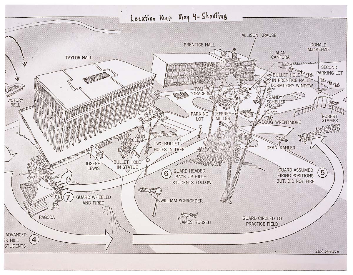
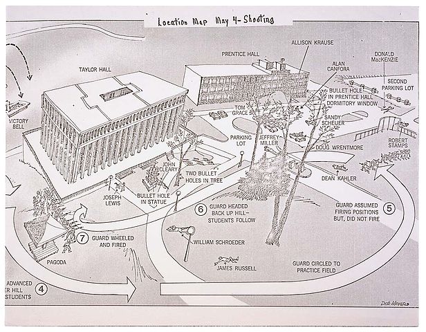
English: This is a printed map detailing the locations of structures, troop movements, bullet hole locations, and locations of casualties at the Kent State shooting of May 4, 1970. |
|||
| Datum | 5/04/1970 | |||
| Quelle | https://catalog.archives.gov/id/596837 | |||
| Urheber | President (1969-1974 : Nixon). President's Commission on Campus Unrest. | |||
| Genehmigung (Weiternutzung dieser Datei) |
|
Lizenz
Dieses Werk ist in den Vereinigten Staaten gemeinfrei, da es von Mitarbeitern der US-amerikanischen Bundesregierung oder einem ihrer Organe in Ausübung ihrer dienstlichen Pflichten erstellt wurde und deshalb nach Titel 17, Kapitel 1, Sektion 105 des US Code ein Werk der Regierung der Vereinigten Staaten von Amerika ist.
Achtung: Dies bezieht sich nur auf originale Werke der Bundesregierung oder eines ihrer Organe, jedoch nicht auf Werke der Regierung eines Bundesstaates oder einer lokalen Behörde. Ebenfalls ausgeschlossen sind seit 1978 herausgegebene Briefmarken und bestimmte Geldmünzen.
|
 | |
| Es wurde festgestellt, dass diese Datei frei von bekannten Beschränkungen durch das Urheberrecht ist, alle verbundenen und verwandten Rechte eingeschlossen. | ||
Dateiversionen
Klicke auf einen Zeitpunkt, um diese Version zu laden.
| Version vom | Vorschaubild | Maße | Benutzer | Kommentar | |
|---|---|---|---|---|---|
| aktuell | 03:26, 9. Jun. 2008 | | 1.200 × 935 (364 KB) | Goldfishbutt | {{Information |Description={{en|1=This is a printed map detailing the locations of structures, troop movements, bullet hole locations, and locations of casualties at the Kent State shooting of May 4, 1970.}} |Source=http://arcweb.archives.gov/arc/arch_res |
Dateiverwendung
Die folgenden 3 Seiten verwenden diese Datei:
Globale Dateiverwendung
Die nachfolgenden anderen Wikis verwenden diese Datei:
- Verwendung auf af.wikipedia.org
- Verwendung auf en.wikipedia.org
- Verwendung auf en.wikibooks.org
- Verwendung auf en.wikiquote.org
- Verwendung auf fr.wikipedia.org
- Verwendung auf he.wikipedia.org
- Verwendung auf it.wikipedia.org
- Verwendung auf ja.wikipedia.org
- Verwendung auf nl.wikipedia.org
- Verwendung auf no.wikipedia.org
- Verwendung auf sv.wikipedia.org
- Verwendung auf zh.wikipedia.org