Datei:Lizars Mexico & Guatimala 1831 UTA.jpg
Originaldatei (6.185 × 5.238 Pixel, Dateigröße: 11,59 MB, MIME-Typ: image/jpeg)
![]()
Diese Datei und die Informationen unter dem roten Trennstrich werden aus dem zentralen Medienarchiv Wikimedia Commons eingebunden.
![]()
Beschreibung
| Titel |
English: Mexico & Guatimala [sic] |
||||||||||||||||||||||||||
| Beschreibung |
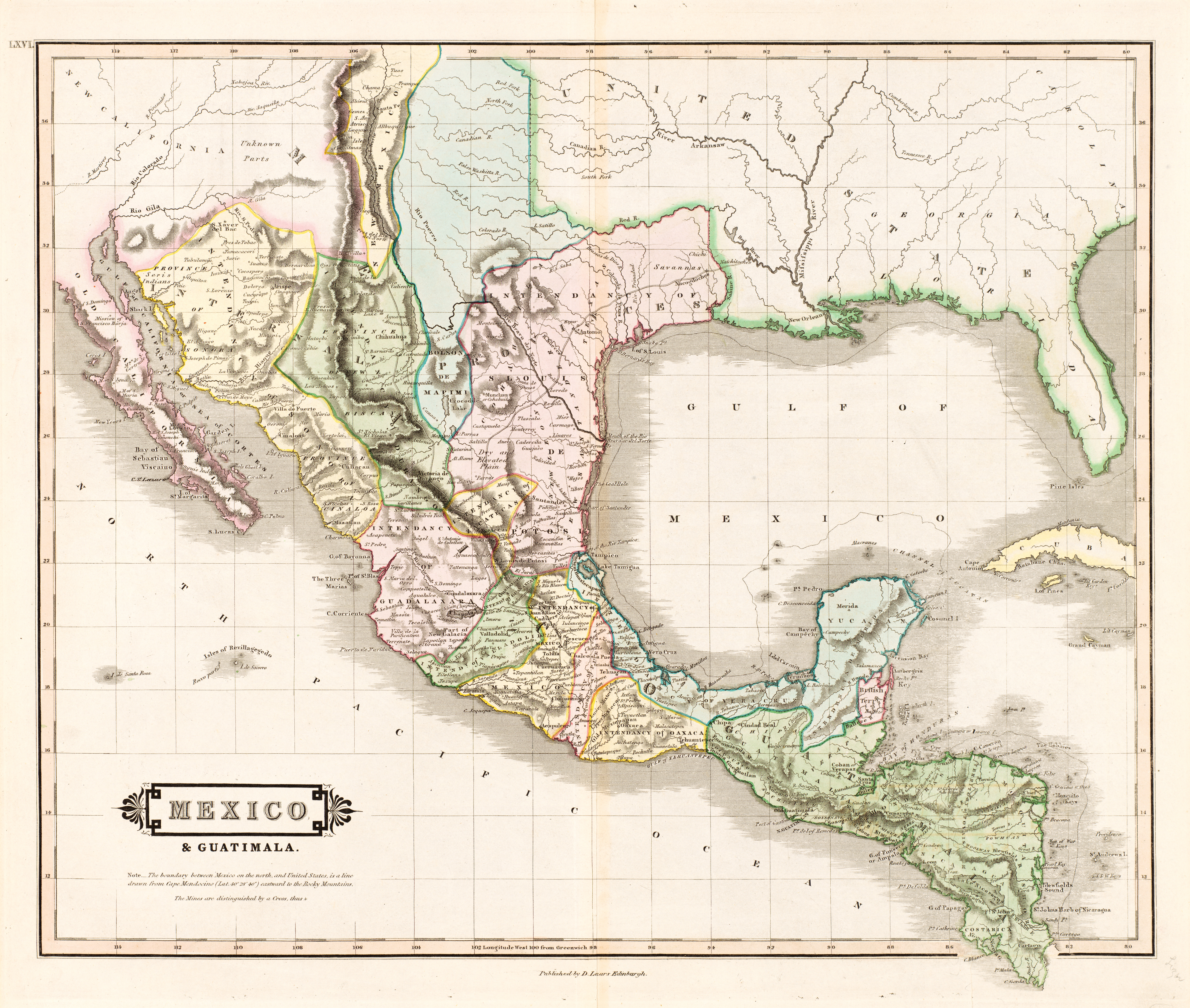
English: The creator of this map was probably Daniel Lizars II (1793-1875), the son of Edinburgh map engraver and publisher Daniel Lizars I (1754-1812) and younger brother of William Home Lizars (1788-1859). Shortly after producing the map, Daniel II went bankrupt in 1832 and emigrated to Canada in 1833. Lizars' map shows Mexico's administrative districts as Intendencies (Intendencias) and Internal Provinces (Provincias Internas) dating from the Spanish era. His depiction of the area that became Texas is notably jarring to modern viewers because his map further exaggerated some of the cartographic errors of his predecessors and contemporaries: particularly, a southerly "dip" of the middle Red River and the southerly courses of the Trinity, Brazos, and Colorado Rivers (which actually flow southeasterly). Settlements shown include Nacogdoches, "St." Antonio, and "Loredo". Interestingly, Lizars included the "British Territory" that became British Honduras or Belize. British logging settlements existed in the territory by the late eighteenth century and, although the British government had been hesitant to create a colony for fear of provoking the Spanish, settlers there were largely self-governing. |
||||||||||||||||||||||||||
| Datum | etwa 1831 | ||||||||||||||||||||||||||
| Quelle | UTA Libraries Cartographic Connections: Karte / Text | ||||||||||||||||||||||||||
| Urheber |
|
||||||||||||||||||||||||||
| Anerkennung |
English: The University of Texas at Arlington Libraries Special Collections, Gift of Virginia Garrett |
||||||||||||||||||||||||||
| Kartografische Angaben | |||||||||||||||||||||||||||
| Ortsbezug |
Mexiko Guatemala Texas |
||||||||||||||||||||||||||
| Georeferenzierung | If inappropriate please set warp_status = skip to hide. | ||||||||||||||||||||||||||
| Bibliographische Angaben | |||||||||||||||||||||||||||
| Publikation |
The Edinburgh Geographical and Historical Atlas |
||||||||||||||||||||||||||
| Urheber |
John Hamilton |
||||||||||||||||||||||||||
| Erscheinungsort |
Edinburgh London Dublin |
||||||||||||||||||||||||||
| Verleger |
John Hamilton Whittaker, Treacher & Co. W. Curry, Jun. & Co. |
||||||||||||||||||||||||||
| Archivalische Angaben | |||||||||||||||||||||||||||
| Sammlung |
|
||||||||||||||||||||||||||
| Maße | Höhe: 42 cm; Breite: 51,5 cm | ||||||||||||||||||||||||||
| Technik | kolorierter Stich auf Papier | ||||||||||||||||||||||||||
| artwork-references |
Worms, Laurence; Ashley Baynton-Williams (2011) British Map Engravers, London: Rare Book Society, S. 406–409 |
||||||||||||||||||||||||||
| Andere Versionen | |||||||||||||||||||||||||||
.jpg)
Lizenz

|
This file was provided to Wikimedia Commons by the University of Texas at Arlington Libraries as part of a cooperation project. The University of Texas at Arlington Libraries is part of the University of Texas at Arlington, a public research university located in Arlington, Texas.
|
|
Der Urheber dieses Werks ist 1875 gestorben; es ist daher gemeinfrei, weil seine urheberrechtliche Schutzfrist abgelaufen ist. Dieses Werk ist gemeinfrei in den Vereinigten Staaten, weil es vor dem 1. Januar 1929 veröffentlicht (oder beim U.S. Copyright Office registriert) wurde. | |
| Es wurde festgestellt, dass diese Datei frei von bekannten Beschränkungen durch das Urheberrecht ist, alle verbundenen und verwandten Rechte eingeschlossen. | |
Dateiversionen
Klicke auf einen Zeitpunkt, um diese Version zu laden.
| Version vom | Vorschaubild | Maße | Benutzer | Kommentar | |
|---|---|---|---|---|---|
| aktuell | 15:26, 13. Jul. 2019 | | 6.185 × 5.238 (11,59 MB) | Michael Barera | == {{int:filedesc}} == {{Map |title = ''Mexico & Guatimala'' [sic] |description = {{en|The creator of this map was probably Daniel Lizars II (1793-1875), the son of Edinburgh map engraver and publisher Daniel Lizars I (1754-1812) and younger brother of William Home Lizars (1788-1859). Shortly after producing the map, Daniel II went bankrupt in 1832 and emigrated to Canada in 1833. Lizars' map shows Mexico's administrative districts as Intendencies (''Intendencias'') and In... |
Dateiverwendung
Keine Seiten verwenden diese Datei.
Globale Dateiverwendung
Die nachfolgenden anderen Wikis verwenden diese Datei:
- Verwendung auf en.wikipedia.org
- Verwendung auf es.wikipedia.org
- Verwendung auf hr.wikipedia.org
- Verwendung auf sh.wikipedia.org