Datei:ISS-26 Tidal flats and channels on Long Island, Bahamas.jpg
Größe dieser Vorschau: 800 × 531 Pixel. Weitere Auflösungen: 320 × 213 Pixel | 640 × 425 Pixel | 1.024 × 680 Pixel | 1.280 × 850 Pixel | 2.560 × 1.700 Pixel | 4.288 × 2.848 Pixel
Originaldatei (4.288 × 2.848 Pixel, Dateigröße: 3,9 MB, MIME-Typ: image/jpeg)
![]()
Diese Datei und die Informationen unter dem roten Trennstrich werden aus dem zentralen Medienarchiv Wikimedia Commons eingebunden.
![]()
Beschreibung
| Beschreibung |
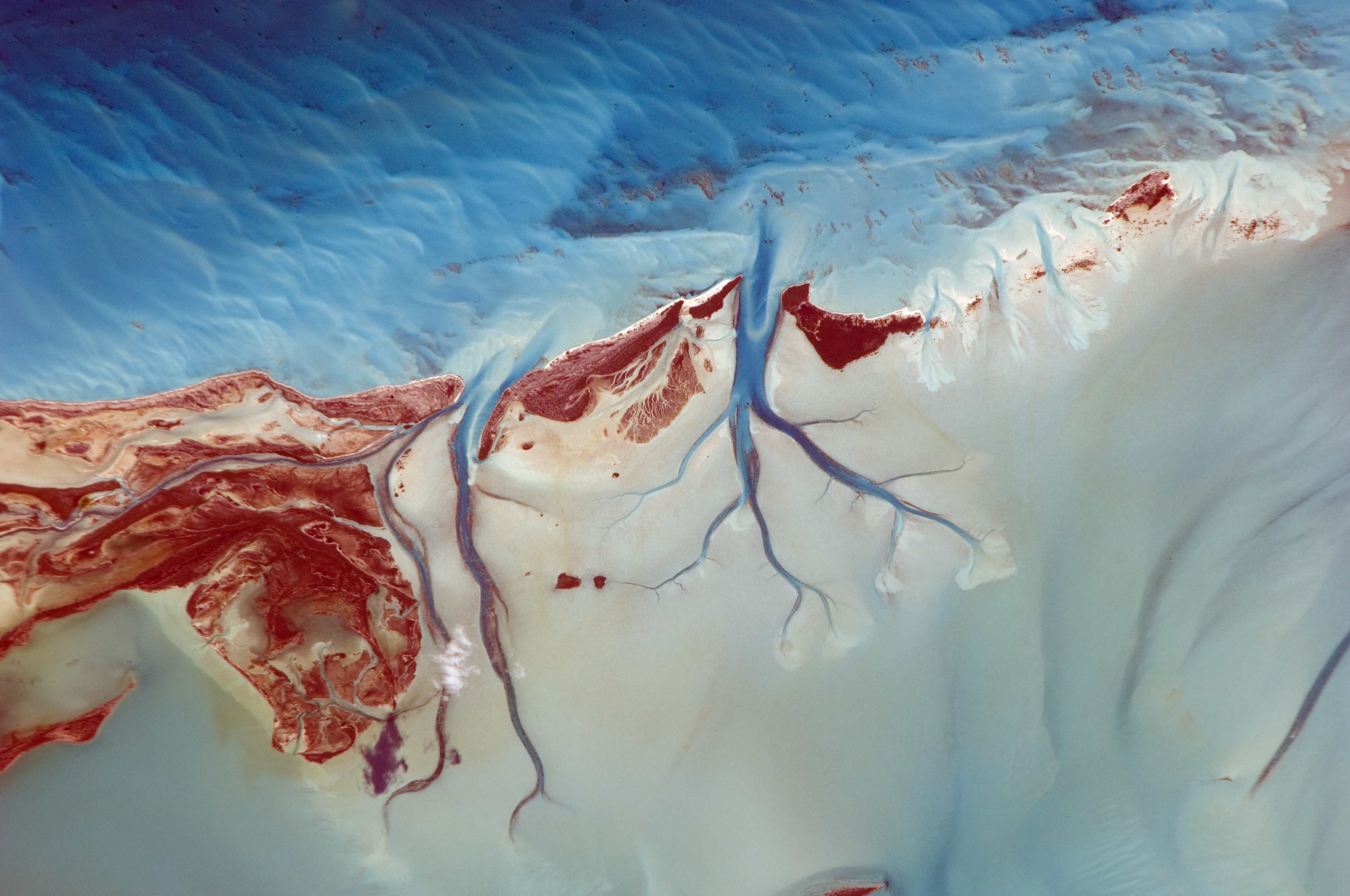
English: Tidal flats and channels on Long Island, Bahamas are featured in this image photographed by an Expedition 26 crew member on the International Space Station.
|
| Datum | |
| Quelle | http://spaceflight.nasa.gov/gallery/images/station/crew-26/html/iss026e005121.html |
| Urheber | NASA |
Diese Mediendatei wurde vom Johnson Space Center der US-amerikanischen National Aeronautics and Space Administration (NASA) unter der Datei-ID ISS026-E-005121 kategorisiert. Diese Markierung zeigt nicht den Urheberrechtsstatus des zugehörigen Werks an. Es ist in jedem Falle zusätzlich eine normale Lizenzvorlage erforderlich. Siehe Commons:Lizenzen für weitere Informationen. Sprachen:
|
Lizenz
Diese Datei ist gemeinfrei (public domain), da sie vom Image Science & Analysis Laboratory der NASA erstellt worden ist. Die NASA-Urheberrechtsrichtlinie besagt, dass „NASA-Material nicht durch Urheberrecht geschützt ist, wenn es nicht anders angegeben ist“ (NASA-Urheberrechtsrichtlinien-Seite oder Nutzungsbedingungen für Fotos von Astronauten). Die Aufnahme ist Teil der Reihe The Gateway to Astronaut Photography of Earth. Bildquelle: ISS026-E-5121.
|
Dateiversionen
Klicke auf einen Zeitpunkt, um diese Version zu laden.
| Version vom | Vorschaubild | Maße | Benutzer | Kommentar | |
|---|---|---|---|---|---|
| aktuell | 18:19, 1. Nov. 2015 | | 4.288 × 2.848 (3,9 MB) | Ras67 | new rendered in high quality from NASA's raw data |
| 16:26, 23. Jun. 2012 |  | 4.288 × 2.848 (720 KB) | Ras67 | {{Information |Description ={{en|1=Tidal flats and channels on Long Island, Bahamas are featured in this image photographed by an Expedition 26 crew member on the International Space Station. * The islands of the Bahamas in the Caribbean Sea are sit... |
Dateiverwendung
Die folgenden 2 Seiten verwenden diese Datei:
Globale Dateiverwendung
Die nachfolgenden anderen Wikis verwenden diese Datei:
- Verwendung auf en.wikipedia.org
- Verwendung auf lt.wikipedia.org
- Verwendung auf uk.wikipedia.org