Datei:Disturnell & Schroeter Map Illustrating the Disputed Boundary Between the United States and Mexico 1853 UTA.jpg

Originaldatei (4.188 × 2.451 Pixel, Dateigröße: 1,24 MB, MIME-Typ: image/jpeg)
![]()
Diese Datei und die Informationen unter dem roten Trennstrich werden aus dem zentralen Medienarchiv Wikimedia Commons eingebunden.
![]()
Beschreibung
| Titel |
English: Map illustrating the Disputed Boundary between the United States and Mexico |
||||||||||||||||||||||||||
| Beschreibung |
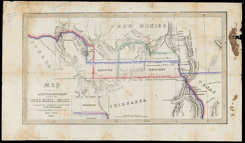
English: Soon after the U.S. and Mexican Boundary Commissions began their surveys in 1849, they noted glaring errors on the 1847 map that had been used to negotiate the Treaty of Guadalupe Hidalgo. The town of El Paso, and thus the boundary itself, had been situated too far to the north on the map, resulting in disagreements between the United States and Mexican governments over exactly where the boundary should be. The New York publisher of the original treaty map, John Disturnell, later issued this map to correct the earlier errors and to illustrate the disputed boundary lines that had resulted (the red for the U.S. claim and the blue for Mexico's). Also, as shown, Americans had learned that even with the corrections in latitude, one of the best routes to California – Cooke's Wagon Road – actually lay south of the new border, and a large lobby of U.S. citizens wanted the land to construct a railroad from El Paso to the Pacific. Given the Mexican government's need for cash, on December 30, 1853, U.S. and Mexican diplomats signed the Gadsden Purchase treaty, whereby the United States paid Mexico $10 million for 29,142,400 acres of a wedge of land within the present states of New Mexico and Arizona. |
||||||||||||||||||||||||||
| Datum | |||||||||||||||||||||||||||
| Quelle | UTA Libraries Cartographic Connections: Karte / Text | ||||||||||||||||||||||||||
| Urheber |
|
||||||||||||||||||||||||||
| Anerkennung |
English: UTA Libraries Special Collections |
||||||||||||||||||||||||||
| Kartografische Angaben | |||||||||||||||||||||||||||
| Ortsbezug |
Vereinigte Staaten Mexiko |
||||||||||||||||||||||||||
| Georeferenzierung | If inappropriate please set warp_status = skip to hide. | ||||||||||||||||||||||||||
| Bibliographische Angaben | |||||||||||||||||||||||||||
| Erscheinungsort | New York City | ||||||||||||||||||||||||||
| Drucker |
|
||||||||||||||||||||||||||
| Archivalische Angaben | |||||||||||||||||||||||||||
| Sammlung |
|
||||||||||||||||||||||||||
| Maße | Höhe: 22,5 cm; Breite: 40 cm | ||||||||||||||||||||||||||
| Technik | kolorierte Lithografie | ||||||||||||||||||||||||||
| artwork-references | Wheat Mapping the Trans-Mississippi West, 3, Nr. 779 , S. 236, 325 | ||||||||||||||||||||||||||
Lizenz

|
This file was provided to Wikimedia Commons by the University of Texas at Arlington Libraries as part of a cooperation project. The University of Texas at Arlington Libraries is part of the University of Texas at Arlington, a public research university located in Arlington, Texas.
|
|
Der Urheber dieses Werks ist 1877 gestorben; es ist daher gemeinfrei, weil seine urheberrechtliche Schutzfrist abgelaufen ist. Dieses Werk ist gemeinfrei in den Vereinigten Staaten, weil es vor dem 1. Januar 1929 veröffentlicht (oder beim U.S. Copyright Office registriert) wurde. | |
| Es wurde festgestellt, dass diese Datei frei von bekannten Beschränkungen durch das Urheberrecht ist, alle verbundenen und verwandten Rechte eingeschlossen. | |
Dateiversionen
Klicke auf einen Zeitpunkt, um diese Version zu laden.
| Version vom | Vorschaubild | Maße | Benutzer | Kommentar | |
|---|---|---|---|---|---|
| aktuell | 20:50, 12. Mär. 2022 | | 4.188 × 2.451 (1,24 MB) | Michael Barera | == {{int:filedesc}} == {{Map |title = {{en|'''''Map illustrating the Disputed Boundary between the United States and Mexico'''''}} |description = {{en|Soon after the U.S. and Mexican Boundary Commissions began their surveys in 1849, they noted glaring errors on the 1847 map that had been used to negotiate the Treaty of Guadalupe Hidalgo. The town of El Paso, and thus the boundary itself, had been situated too far to the north on the map, resulting in disagreements between... |
Dateiverwendung
Die folgende Seite verwendet diese Datei:
Globale Dateiverwendung
Die nachfolgenden anderen Wikis verwenden diese Datei:
- Verwendung auf es.wikipedia.org
- Verwendung auf fr.wikipedia.org
- Verwendung auf hu.wikipedia.org
- Verwendung auf ko.wikipedia.org