Datei:Carte Lewis and Clark Expedition.png
Größe dieser Vorschau: 800 × 520 Pixel. Weitere Auflösungen: 320 × 208 Pixel | 640 × 416 Pixel | 1.024 × 665 Pixel | 1.513 × 983 Pixel
Originaldatei (1.513 × 983 Pixel, Dateigröße: 84 KB, MIME-Typ: image/png)
![]()
Diese Datei und die Informationen unter dem roten Trennstrich werden aus dem zentralen Medienarchiv Wikimedia Commons eingebunden.
![]()

|
Dieses Bild des Typs Historical map sollte als Vektorgrafik im SVG-Format neu erstellt werden. Vektorformate haben zahlreiche Vorteile; weitere Information unter Commons:Media for cleanup. Wenn dir eine SVG-Version dieses Bildes vorliegt, so lade diese bitte hoch. Nach dem Hochladen der Datei ist diese Vorlage auf der aktuellen Bildbeschreibungsseite durch die Vorlage {{Vector version available}}, oder kürzer {{Vva}}, zu ersetzen. Es ist empfohlen die neue SVG-Datei „Carte Lewis and Clark Expedition.svg“ zu nennen – dann benötigt die Vorlage vector version available (bzw. vva) keinen Parameter.
|
Beschreibung
| Beschreibung |
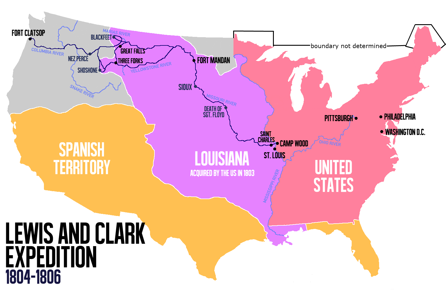
English: Route of the Lewis and Clark Expedition |
| Datum | |
| Quelle |
Eigenes Werk, Diese Datei wurde von diesem Werk abgeleitet: Carte Lewis-Clark Expedition-en.png |
| Urheber | Victor van Werkhooven |
| Andere Versionen |
 |
Lizenz
| Ich, der Urheberrechtsinhaber dieses Werkes, veröffentliche es als gemeinfrei. Dies gilt weltweit. In manchen Staaten könnte dies rechtlich nicht möglich sein. Sofern dies der Fall ist: Ich gewähre jedem das bedingungslose Recht, dieses Werk für jedweden Zweck zu nutzen, es sei denn, Bedingungen sind gesetzlich erforderlich. |
Dateiversionen
Klicke auf einen Zeitpunkt, um diese Version zu laden.
| Version vom | Vorschaubild | Maße | Benutzer | Kommentar | |
|---|---|---|---|---|---|
| aktuell | 16:21, 13. Jun. 2014 | | 1.513 × 983 (84 KB) | Nwbeeson | Reverted to version as of 14:18, 13 June 2014 |
| 16:20, 13. Jun. 2014 |  | 1.513 × 983 (84 KB) | Nwbeeson | Corrected boundary of the United States. The original left out Maine, Michigan, Wisconsin, and part of Minnesota, none of which were states, but all of which were definitely part of the territory of the United States. | |
| 16:18, 13. Jun. 2014 |  | 1.513 × 983 (84 KB) | Nwbeeson | Corrected boundary of the United States. The original left out Maine, Michigan, Wisconsin, and part of Minnesota, none of which were states, but all of which were definitely part of the territory of the United States. | |
| 17:17, 22. Mai 2014 |  | 1.513 × 983 (134 KB) | Luctor | User created page with UploadWizard |
Dateiverwendung
Die folgende Seite verwendet diese Datei:
Globale Dateiverwendung
Die nachfolgenden anderen Wikis verwenden diese Datei:
- Verwendung auf ast.wikipedia.org
- Verwendung auf bn.wikipedia.org
- Verwendung auf en.wikipedia.org
- Verwendung auf es.wikipedia.org
- Verwendung auf et.wikipedia.org
- Verwendung auf eu.wikipedia.org
- Verwendung auf fa.wikipedia.org
- Verwendung auf gl.wikipedia.org
- Verwendung auf hu.wikipedia.org
- Verwendung auf it.wikipedia.org
- Verwendung auf ko.wikipedia.org
- Verwendung auf ms.wikipedia.org
- Verwendung auf nl.wikipedia.org
- Verwendung auf no.wikipedia.org
- Verwendung auf oc.wikipedia.org
- Verwendung auf pl.wikipedia.org
- Verwendung auf sr.wikipedia.org
- Verwendung auf tr.wikipedia.org
- Verwendung auf www.wikidata.org
- Verwendung auf zh.wikipedia.org