Datei:PIA15276 Locator Map for 'Greeley Haven' on Endeavour Rim.jpg

PIA15276_Locator_Map_for_'Greeley_Haven'_on_Endeavour_Rim.jpg (700 × 560 Pixel, Dateigröße: 55 KB, MIME-Typ: image/jpeg)
![]()
Diese Datei und die Informationen unter dem roten Trennstrich werden aus dem zentralen Medienarchiv Wikimedia Commons eingebunden.
![]()
Beschreibung
| Beschreibung |
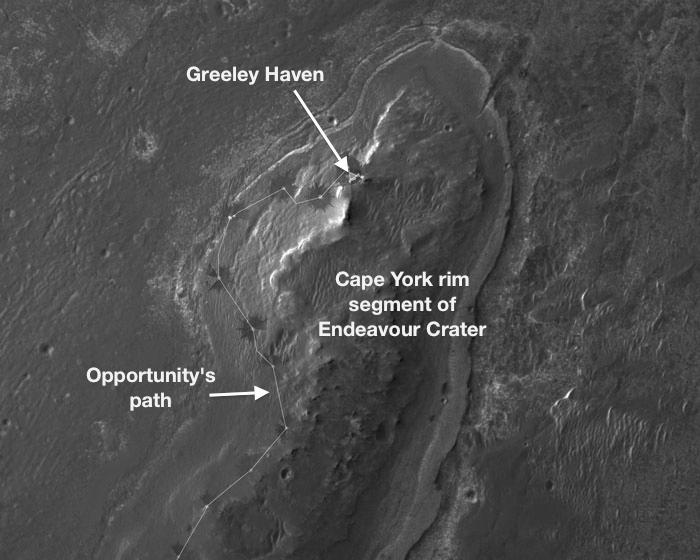
English: NASA's Mars Exploration Rover Opportunity will spend its fifth Martian winter working at a location informally named "Greeley Haven." This site is an outcrop near the northern tip of the "Cape York" segment of the western rim of Endeavour Crater. It provides a north-facing slope of 15 degrees or more to aid electric output from Opportunity's solar array. It also presents geological targets of interest for investigating during months of limited mobility while the rover stays on the slope.
This image, covering an area about 2,000 feet (about 600 meters) wide, indicates the location of Greeley Haven on Cape York. The base image of the map is a portion of an image taken by the High Resolution Imaging Science Experiment (HiRISE) instrument on NASA's Mars Reconnaissance Orbiter, on July 23, 2010. Other image products from this observation are available at http://hirise.lpl.arizona.edu/ESP_018701_1775. NASA's Jet Propulsion Laboratory, a division of the California Institute of Technology, Pasadena, manages the Mars Exploration Rover Project and the Mars Reconnaissance Orbiter Project for the NASA Science Mission Directorate, Washington.The University of Arizona, Tucson, operates the HiRISE camera, which was built by Ball Aerospace & Technologies Corp., Boulder, Colo. Lockheed Martin Space Systems, Denver, is the spacecraft development and integration contractor for the project and built the spacecraft. |
| Datum | (published 5. Januar 2012) |
| Quelle | Catalog page · Full-res (JPEG · TIFF) |
| Urheber | NASA/JPL-Caltech/UA |
| Position auf dem Mars | Dieses und weitere Bilder auf Google Maps |
|---|
Diese Mediendatei wurde vom Jet Propulsion Lab der US-amerikanischen National Aeronautics and Space Administration (NASA) unter der Datei-ID PIA15276 kategorisiert. Diese Markierung zeigt nicht den Urheberrechtsstatus des zugehörigen Werks an. Es ist in jedem Falle zusätzlich eine normale Lizenzvorlage erforderlich. Siehe Commons:Lizenzen für weitere Informationen. Sprachen:
|
 |
This media is a product of the Mars Reconnaissance Orbiter mission Credit and attribution belongs to the mission team, if not already specified in the "author" row |
Lizenz
| Diese Datei ist gemeinfrei (public domain), da sie von der NASA erstellt worden ist. Die NASA-Urheberrechtsrichtlinie besagt, dass „NASA-Material nicht durch Urheberrecht geschützt ist, wenn es nicht anders angegeben ist“. (NASA-Urheberrechtsrichtlinie-Seite oder JPL Image Use Policy). | ||
 |
Warnung:
|
Dateiversionen
Klicke auf einen Zeitpunkt, um diese Version zu laden.
| Version vom | Vorschaubild | Maße | Benutzer | Kommentar | |
|---|---|---|---|---|---|
| aktuell | 22:47, 7. Jan. 2017 | | 700 × 560 (55 KB) | PhilipTerryGraham | Original resolution. Previous version was an upscale. |
| 22:43, 16. Jun. 2012 |  | 946 × 710 (175 KB) | MoreInput | {{Information |Description ={{en|1=Locator Map for 'Greeley Haven' on Endeavour Rim}} {{de|1=Karte der Position von Opportunity bei 'Greeley Haven' am Rand des Endeavour Kraters}} |Source =http://www.nasa.gov/mission_pages/mer/multimedia/pia... |
Dateiverwendung
Keine Seiten verwenden diese Datei.
Globale Dateiverwendung
Die nachfolgenden anderen Wikis verwenden diese Datei:
- Verwendung auf en.wikipedia.org