Datei:The Man in the High Castle Plausible World Map.png
Größe dieser Vorschau: 800 × 579 Pixel. Weitere Auflösungen: 320 × 232 Pixel | 640 × 463 Pixel | 1.024 × 741 Pixel | 1.280 × 926 Pixel | 1.577 × 1.141 Pixel
Originaldatei (1.577 × 1.141 Pixel, Dateigröße: 400 KB, MIME-Typ: image/png)
![]()
Diese Datei und die Informationen unter dem roten Trennstrich werden aus dem zentralen Medienarchiv Wikimedia Commons eingebunden.
![]()

|
This map, as well as other fictitious maps, is fictitious or too incorrect (i.e. due to anachronism) to be used in real-life contexts (contemporary or historic). It may have some visual elements that are similar to official maps such as colors or certain layout features, but they are NOT official and don't have any official recognition. |
[[Category:]]
Beschreibung
| Beschreibung |
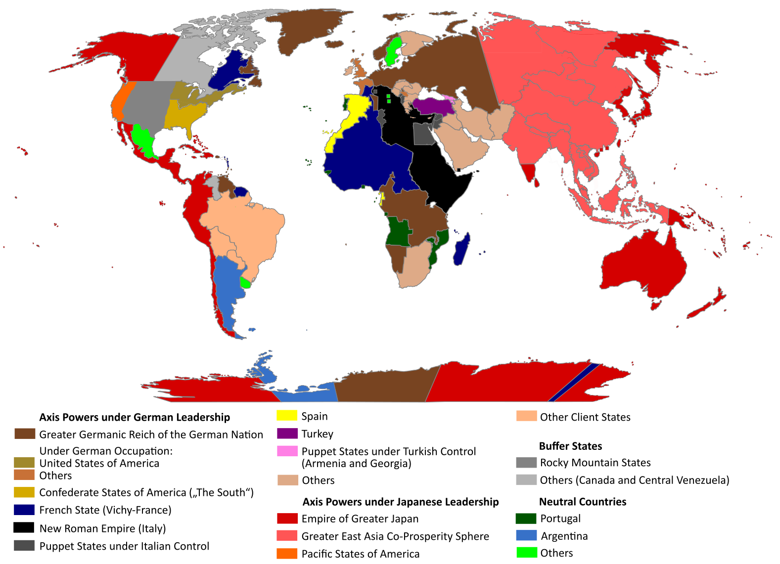
English: "The Man in the High Castle" is an alternate history novel by Philip K. Dick. It is set in a world in which the Axis powers have won World War II. This map is inspired by Dick's story and shows a plausible division of the world between Nazi Germany (dark brown), Imperial Japan (dark red) and their respective allies. However, the map is much more precise than the book describes.
https://web.archive.org/web/20191202005150/http://www.high-castle-world-map.com:80/ |
| Datum | |
| Quelle | Eigenes Werk |
| Urheber | RobintheHighCastle |
| Genehmigung (Weiternutzung dieser Datei) |
Lizenz
Ich, der Urheber dieses Werkes, veröffentliche es unter der folgenden Lizenz:
Diese Datei ist lizenziert unter der Creative-Commons-Lizenz „Namensnennung – Weitergabe unter gleichen Bedingungen 4.0 international“.
- Dieses Werk darf von dir
- verbreitet werden – vervielfältigt, verbreitet und öffentlich zugänglich gemacht werden
- neu zusammengestellt werden – abgewandelt und bearbeitet werden
- Zu den folgenden Bedingungen:
- Namensnennung – Du musst angemessene Urheber- und Rechteangaben machen, einen Link zur Lizenz beifügen und angeben, ob Änderungen vorgenommen wurden. Diese Angaben dürfen in jeder angemessenen Art und Weise gemacht werden, allerdings nicht so, dass der Eindruck entsteht, der Lizenzgeber unterstütze gerade dich oder deine Nutzung besonders.
- Weitergabe unter gleichen Bedingungen – Wenn du das Material wiedermischst, transformierst oder darauf aufbaust, musst du deine Beiträge unter der gleichen oder einer kompatiblen Lizenz wie das Original verbreiten.
Dateiversionen
Klicke auf einen Zeitpunkt, um diese Version zu laden.
| Version vom | Vorschaubild | Maße | Benutzer | Kommentar | |
|---|---|---|---|---|---|
| aktuell | 16:55, 29. Okt. 2021 | | 1.577 × 1.141 (400 KB) | Saltner67 | Added the portoguese colonies Cabinda and Ajuda since they would still have existed in this world. |
| 10:05, 20. Jun. 2021 |  | 1.613 × 1.143 (417 KB) | Gernsback67 | Changed "Greater Asian Co-Prosperity Sphere" in "Greater East Asia Co-Prosperity Sphere", which is correct. | |
| 17:30, 16. Okt. 2020 |  | 1.611 × 1.138 (418 KB) | Saltner67 | Restored the latest version. Please do not revert any changes, which have been made to this file so far, without any communication with the author of the map. All changes made here have been initialized by the author and are a result of the same process which has led to the creation of the map in the first place. | |
| 10:25, 16. Okt. 2020 |  | 1.621 × 1.137 (392 KB) | Gooduserdude | RV Original research: this image is based on a source and should not be altered | |
| 16:15, 29. Mär. 2020 |  | 1.611 × 1.138 (418 KB) | Saltner67 | Improved the accuracy of borders of Mongolia and Manchukuo. | |
| 17:58, 27. Mär. 2020 |  | 1.607 × 1.138 (418 KB) | Saltner67 | Enlarged Manchukuo and added the puppet states of Yakutia and Krasnoyarsk/Irkutsk after more research on Kantokuen. | |
| 21:07, 12. Mär. 2020 |  | 1.612 × 1.143 (411 KB) | Saltner67 | Moved the Swiss Canton of Valais from Germany to Italy, as has been prepared in the plans for Operation Tannenbaum. | |
| 20:57, 8. Feb. 2020 |  | 1.605 × 1.139 (411 KB) | Saltner67 | Reinserted the territories of Tunisia,Greece, Crete and Cyprus after research on the Italian plannings and Greece in WWII. | |
| 15:21, 21. Nov. 2019 |  | 1.611 × 1.133 (409 KB) | Gernsback67 | Enlarged Mongolia again after more research on pan-mongolism. | |
| 17:13, 21. Sep. 2019 |  | 1.610 × 1.137 (408 KB) | Saltner67 | unified Mongolia, enlarged Manchukuo and Thailand, re-inserted the real-life borders of Laos and Vietnam after research on Demchugdongrub, Kantokuen, Thailand and Indochina in WWII |
Dateiverwendung
Die folgende Seite verwendet diese Datei:
Globale Dateiverwendung
Die nachfolgenden anderen Wikis verwenden diese Datei:
- Verwendung auf ar.wikipedia.org
- Verwendung auf cs.wikipedia.org
- Verwendung auf da.wikipedia.org
- Verwendung auf en.wikipedia.org
- Verwendung auf en.wikiquote.org
- Verwendung auf es.wikipedia.org
- Verwendung auf gl.wikipedia.org
- Verwendung auf he.wikipedia.org
- Verwendung auf hu.wikipedia.org
- Verwendung auf it.wikipedia.org
- Verwendung auf ja.wikipedia.org
- Verwendung auf ko.wikipedia.org
- Verwendung auf lt.wikipedia.org
- Verwendung auf nl.wikipedia.org
- Verwendung auf pl.wikipedia.org
- Verwendung auf pt.wikipedia.org
- Verwendung auf ro.wikipedia.org
- Verwendung auf ru.wikipedia.org
- Verwendung auf th.wikipedia.org
- Verwendung auf uk.wikipedia.org
- Verwendung auf zh-classical.wikipedia.org
- Verwendung auf zh.wikipedia.org