Datei:Seawalls in Taro town. Damage occurred to the eastern parts of the new seawalls -9-11-2011.jpg

Größe dieser Vorschau: 800 × 430 Pixel. Weitere Auflösungen: 320 × 172 Pixel | 640 × 344 Pixel | 1.024 × 551 Pixel | 1.535 × 826 Pixel
Originaldatei (1.535 × 826 Pixel, Dateigröße: 209 KB, MIME-Typ: image/jpeg)
![]()
Diese Datei und die Informationen unter dem roten Trennstrich werden aus dem zentralen Medienarchiv Wikimedia Commons eingebunden.
![]()
Beschreibung
| Beschreibung |
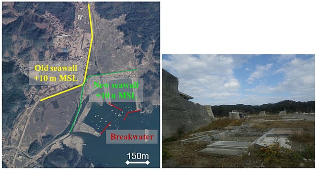
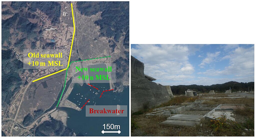
English: Source: Anawat Suppasri, Nobuo Shuto, Fumihiko Imamura, Shunichi Koshimura, Erick Mas, Ahmet Cevdet Yalciner: "Lessons Learned from the 2011 Great East Japan Tsunami: Performance of Tsunami Countermeasures, Coastal Buildings, and Tsunami Evacuation in Japan", Pure and Applied Geophysics, 170, 6-8, (2013), pp. 993–1018, DOI:10.1007/s00024-012-0511-7, online published on 7 July 2012, here: p. 999, Figure 7 ("Seawalls in Taro town. Damage occurred to the eastern parts of the new seawalls (9/11/2011)"), Licence: Creative Commons Attribution 2.0 Generic (CC BY 2.0).
Caption as given in the above cited source: "Figure 7 - Seawalls in Taro town. Damage occurred to the eastern parts of the new seawalls (9/11/2011)" Context as given in the above cited source: "Seawalls are found almost everywhere along the coasts of Japan. According to reports from Ministry of Land, Infrastructure, Transport, and Tourism (MLIT, 2011), the length of the seawalls damaged and destroyed in Iwate, Miyagi, and Fukushima prefectures is ~190 km out of a total length of ~300 km. According to the reports, tsunami overflows of <1 m caused a relatively small amount of damage but overflows larger than 3–4 m completely destroyed the seawalls because most of them were designed to protect the land from high tides or typhoons. However, some of them, for example the seawall in Taro town, were meant to serve as tsunami barriers. Taro town experienced tsunamis in 1611, 1896 (a tsunami height of 15 m, 83 % fatality, and 100 % of the houses destroyed) and 1933 (a tsunami height of 10 m, 32 % fatality, and 63 % of the houses destroyed). In 1934, construction of two, 10 m high seawalls (measured from the mean seawater level) was started; the purpose of the seawalls was to protect the town by allowing the tsunami to flow along both sides of the seawalls. They were completed in 1958, two years before the 1960 Chile tsunami, and could fully protect the town from a maximum tsunami height of 3.5 m. In the 1970s, the town constructed another two lines of 10 m high seawalls to accommodate the increasing population (Kamaishi port office, 2011). The total length of the seawalls is ~2.4 km, as shown in Fig. 7, left. The designs of both of the seawalls took only the 1933 tsunami into consideration. However, the 2011 tsunami flowed over the two-line seawalls, damaged most houses, with 5 % fatality, and destroyed the eastern part of the new seawall (Fig. 7, right)." |
| Datum | |
| Quelle | Anawat Suppasri, Nobuo Shuto, Fumihiko Imamura, Shunichi Koshimura, Erick Mas, Ahmet Cevdet Yalciner: "Lessons Learned from the 2011 Great East Japan Tsunami: Performance of Tsunami Countermeasures, Coastal Buildings, and Tsunami Evacuation in Japan", Pure and Applied Geophysics, 170, 6-8, (2013), pp. 993–1018, DOI:10.1007/s00024-012-0511-7, online published on 7 July 2012, here: p. 999, Figure 7 ("Seawalls in Taro town. Damage occurred to the eastern parts of the new seawalls (9/11/2011)"), Licence: Creative Commons Attribution 2.0 Generic (CC BY 2.0). |
| Urheber | Anawat Suppasri, Nobuo Shuto, Fumihiko Imamura, Shunichi Koshimura, Erick Mas, Ahmet Cevdet Yalciner: "Lessons Learned from the 2011 Great East Japan Tsunami: Performance of Tsunami Countermeasures, Coastal Buildings, and Tsunami Evacuation in Japan", Pure and Applied Geophysics, 170, 6-8, (2013), pp. 993–1018, DOI:10.1007/s00024-012-0511-7, online published on 7 July 2012, here: p. 999, Figure 7 ("Seawalls in Taro town. Damage occurred to the eastern parts of the new seawalls (9/11/2011)"), Licence: Creative Commons Attribution 2.0 Generic (CC BY 2.0). |
| Genehmigung (Weiternutzung dieser Datei) |
Diese Datei ist unter der Creative-Commons-Lizenz „Namensnennung 2.0 generisch“ (US-amerikanisch) lizenziert. Namensnennung: Anawat Suppasri, Nobuo Shuto, Fumihiko Imamura, Shunichi Koshimura, Erick Mas, Ahmet Cevdet Yalciner
|
Dateiversionen
Klicke auf einen Zeitpunkt, um diese Version zu laden.
| Version vom | Vorschaubild | Maße | Benutzer | Kommentar | |
|---|---|---|---|---|---|
| aktuell | 17:09, 17. Aug. 2018 | | 1.535 × 826 (209 KB) | Anglo-Araneophilus~commonswiki | {{Information |description ={{en|1=Source: Anawat Suppasri, Nobuo Shuto, Fumihiko Imamura, Shunichi Koshimura, Erick Mas, Ahmet Cevdet Yalciner: "Lessons Learned from the 2011 Great East Japan Tsunami: Performance of Tsunami Countermeasures, Coastal Buildings, and Tsunami Evacuation in Japan", Pure and Applied Geophysics, 170, 6-8, (2013), pp. 993–1018, DOI:10.1007/s00024-012-0511-7, online published on 7 July 2012, here: p. 999, Figure 7 ("Seawalls in Taro town. Damage occurred to the east... |
Dateiverwendung
Die folgende Seite verwendet diese Datei: