Datei:Map of the tunnels of the Faroe Islands.png

Größe dieser Vorschau: 568 × 600 Pixel. Weitere Auflösungen: 227 × 240 Pixel | 455 × 480 Pixel | 728 × 768 Pixel | 970 × 1.024 Pixel | 1.940 × 2.048 Pixel | 3.027 × 3.195 Pixel
Originaldatei (3.027 × 3.195 Pixel, Dateigröße: 3,21 MB, MIME-Typ: image/png)
![]()
Diese Datei und die Informationen unter dem roten Trennstrich werden aus dem zentralen Medienarchiv Wikimedia Commons eingebunden.
![]()

|
Dieses Bild des Typs Map sollte als Vektorgrafik im SVG-Format neu erstellt werden. Vektorformate haben zahlreiche Vorteile; weitere Information unter Commons:Media for cleanup. Wenn dir eine SVG-Version dieses Bildes vorliegt, so lade diese bitte hoch. Nach dem Hochladen der Datei ist diese Vorlage auf der aktuellen Bildbeschreibungsseite durch die Vorlage {{Vector version available}}, oder kürzer {{Vva}}, zu ersetzen. Es ist empfohlen die neue SVG-Datei „Map of the tunnels of the Faroe Islands.svg“ zu nennen – dann benötigt die Vorlage vector version available (bzw. vva) keinen Parameter.
|
| Beschreibung |
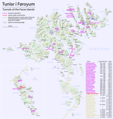
Català: Mapa dels túnels de les Illes Fèroe
Deutsch: Karte der Tunnel auf den Färöern
English: Map of the tunnels of the Faroe Islands |
| Datum | see file history |
| Quelle | Eigenes Werk, using Openstreetmap data for the background |
| Urheber | Maximilian Dörrbecker (Chumwa) |
| Genehmigung (Weiternutzung dieser Datei) |
All OpenStreetMap data and maps are Creative Commons "CC-BY-SA 2.0" licensed Diese Datei ist unter der Creative-Commons-Lizenz „Namensnennung – Weitergabe unter gleichen Bedingungen 2.0 generisch“ (US-amerikanisch) lizenziert.
|
Dateiversionen
Klicke auf einen Zeitpunkt, um diese Version zu laden.
| Version vom | Vorschaubild | Maße | Benutzer | Kommentar | |
|---|---|---|---|---|---|
| aktuell | 20:19, 19. Dez. 2020 | | 3.027 × 3.195 (3,21 MB) | Karl432 | Eysturoyatunnilin opened on 2020-12-19 |
| 09:51, 23. Dez. 2016 |  | 3.027 × 3.195 (3,21 MB) | Chumwa | ||
| 18:31, 21. Dez. 2016 |  | 3.027 × 3.195 (3,02 MB) | Chumwa | ||
| 01:09, 21. Dez. 2016 |  | 3.011 × 3.195 (946 KB) | Chumwa | ||
| 00:34, 21. Dez. 2016 |  | 3.011 × 3.195 (942 KB) | Chumwa | ||
| 23:15, 19. Dez. 2016 |  | 3.011 × 3.195 (929 KB) | Chumwa | ||
| 08:36, 19. Dez. 2016 |  | 3.011 × 3.195 (904 KB) | Chumwa | ||
| 01:05, 19. Dez. 2016 |  | 3.011 × 3.195 (886 KB) | Chumwa | ||
| 20:53, 18. Dez. 2016 |  | 3.011 × 3.195 (902 KB) | Chumwa | {{Information |Description= {{de|Karte der Tunnel auf den Färöern}} {{en|Map of the tunnels of the Faroe Islands}} |Author=Maximilian Dörrbecker (Chumwa) |Source={{own}}, using Openstreetmap data for the back... |
Dateiverwendung
Die folgenden 5 Seiten verwenden diese Datei:
Globale Dateiverwendung
Die nachfolgenden anderen Wikis verwenden diese Datei:
- Verwendung auf ca.wikipedia.org
- Verwendung auf cs.wikipedia.org
- Verwendung auf da.wikipedia.org
- Verwendung auf en.wikipedia.org
- Verwendung auf en.wikivoyage.org
- Verwendung auf fo.wikipedia.org
- Verwendung auf fr.wikipedia.org
- Verwendung auf hu.wikipedia.org
- Verwendung auf is.wikipedia.org
- Verwendung auf it.wikipedia.org
- Verwendung auf nl.wikipedia.org
- Verwendung auf no.wikipedia.org
- Verwendung auf sv.wikipedia.org