Datei:Lasvegasairportmap.png
Größe dieser Vorschau: 598 × 600 Pixel. Weitere Auflösungen: 239 × 240 Pixel | 479 × 480 Pixel | 1.000 × 1.003 Pixel
Originaldatei (1.000 × 1.003 Pixel, Dateigröße: 497 KB, MIME-Typ: image/png)
![]()
Diese Datei und die Informationen unter dem roten Trennstrich werden aus dem zentralen Medienarchiv Wikimedia Commons eingebunden.
![]()
Beschreibung
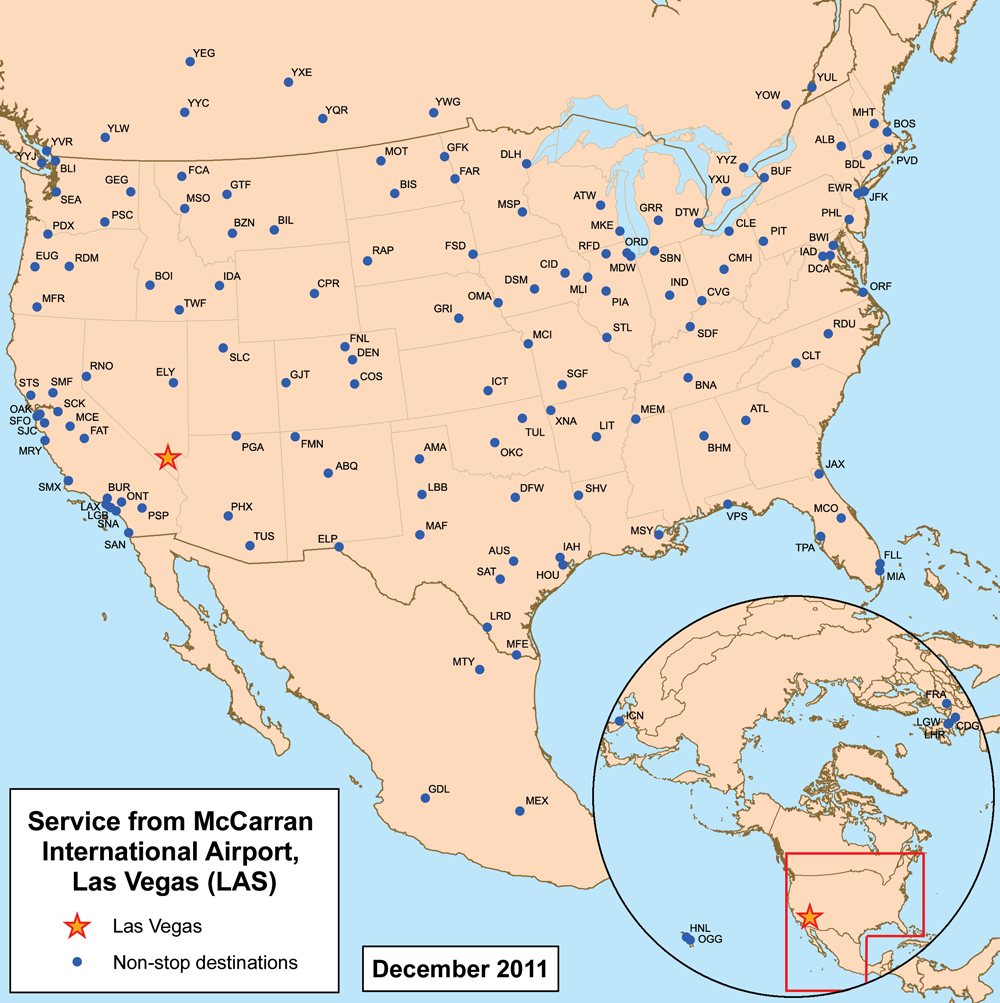
| Beschreibung | This is a route map for McCarran International Airport serving Las Vegas as of February 2007. Map is an Azimuthal equidistant projection centered on the airport so straight lines from Las Vegas are along great circle routes. Source. |
| Datum | 27. Februar 2007 (Original-Hochladedatum) |
| Quelle | Die Autorenschaft wurde nicht in einer maschinell lesbaren Form angegeben. Es wird angenommen, dass es sich um ein eigenes Werk handelt (basierend auf den Rechteinhaber-Angaben). |
| Urheber | Die Autorenschaft wurde nicht in einer maschinell lesbaren Form angegeben. Es wird Kmusser als Autor angenommen (basierend auf den Rechteinhaber-Angaben). |
Lizenz
Ich, der Urheber dieses Werkes, veröffentliche es unter der folgenden Lizenz:
Diese Datei ist unter der Creative-Commons-Lizenz „Namensnennung – Weitergabe unter gleichen Bedingungen 2.5 generisch“ (US-amerikanisch) lizenziert.
- Dieses Werk darf von dir
- verbreitet werden – vervielfältigt, verbreitet und öffentlich zugänglich gemacht werden
- neu zusammengestellt werden – abgewandelt und bearbeitet werden
- Zu den folgenden Bedingungen:
- Namensnennung – Du musst angemessene Urheber- und Rechteangaben machen, einen Link zur Lizenz beifügen und angeben, ob Änderungen vorgenommen wurden. Diese Angaben dürfen in jeder angemessenen Art und Weise gemacht werden, allerdings nicht so, dass der Eindruck entsteht, der Lizenzgeber unterstütze gerade dich oder deine Nutzung besonders.
- Weitergabe unter gleichen Bedingungen – Wenn du das Material wiedermischst, transformierst oder darauf aufbaust, musst du deine Beiträge unter der gleichen oder einer kompatiblen Lizenz wie das Original verbreiten.
Dateiversionen
Klicke auf einen Zeitpunkt, um diese Version zu laden.
| Version vom | Vorschaubild | Maße | Benutzer | Kommentar | |
|---|---|---|---|---|---|
| aktuell | 03:56, 25. Jul. 2011 | | 1.000 × 1.003 (497 KB) | Kmusser | updated destinations |
| 23:19, 6. Apr. 2009 |  | 2.550 × 2.550 (3,37 MB) | Kmusser | Updated destinations | |
| 21:46, 8. Mai 2007 |  | 2.550 × 2.550 (741 KB) | Kmusser | Correction, removed some airports. | |
| 23:04, 27. Feb. 2007 |  | 2.550 × 2.550 (745 KB) | Kmusser | == Summary == This is a route map for en:McCarran International AirportMcCarran International Airport serving Las Vegas as of February 2007. Map is an [[:en:Azimuthal equidistant projection|Azimuthal equidistant projection] |
Dateiverwendung
Keine Seiten verwenden diese Datei.
Globale Dateiverwendung
Die nachfolgenden anderen Wikis verwenden diese Datei:
- Verwendung auf da.wikipedia.org
- Verwendung auf en.wikipedia.org
- Verwendung auf ru.wikipedia.org
- Verwendung auf vi.wikipedia.org