Datei:Hvo controlled.png
Originaldatei (1.220 × 1.100 Pixel, Dateigröße: 99 KB, MIME-Typ: image/png)
![]()
Diese Datei und die Informationen unter dem roten Trennstrich werden aus dem zentralen Medienarchiv Wikimedia Commons eingebunden.
![]()
Beschreibung
(
| Beschreibung |
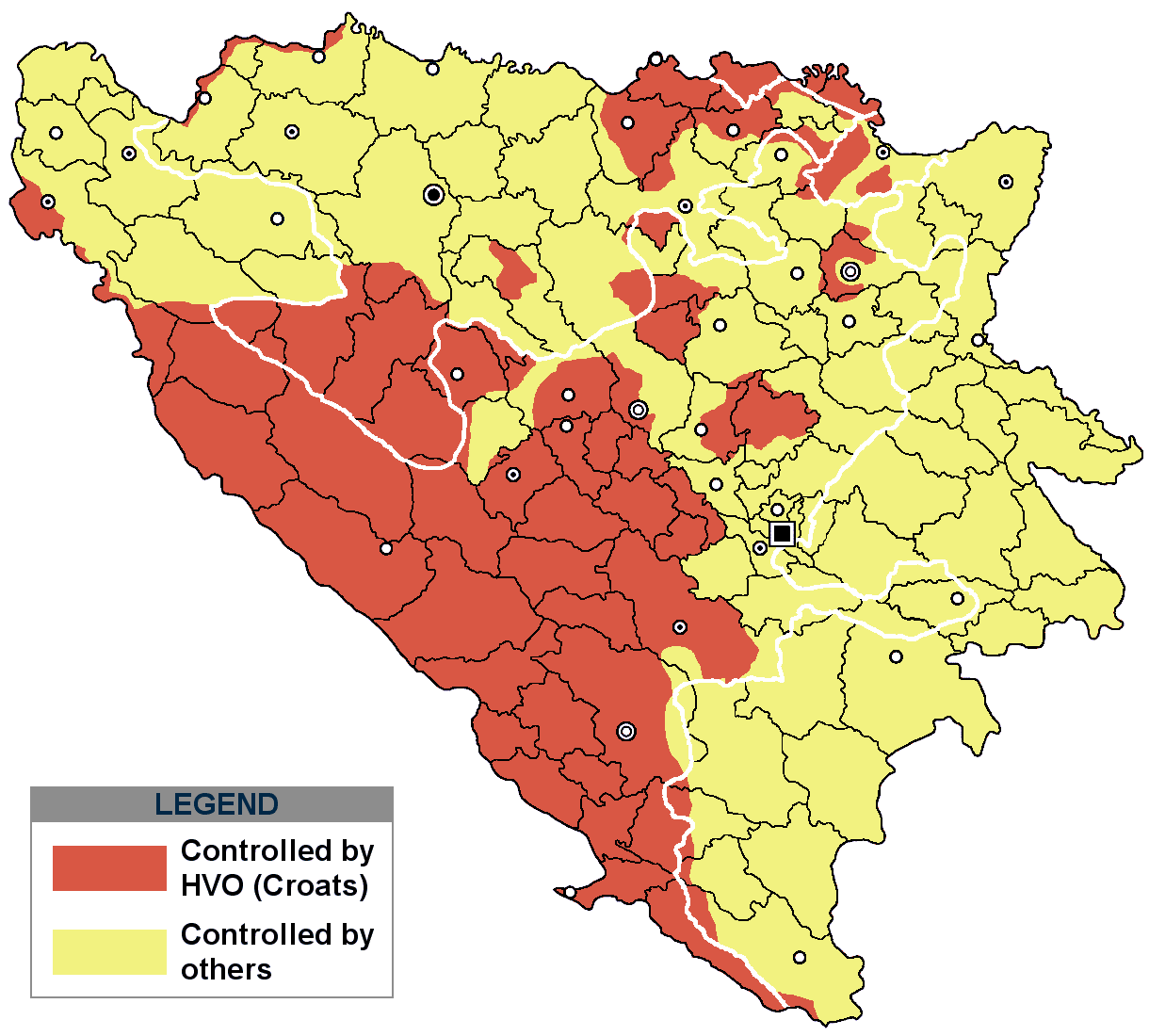
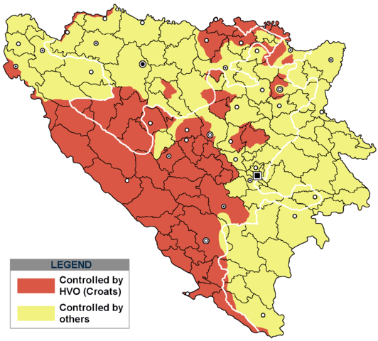
This is an update for the previous map, as the HVO never controlled all parts of municipality of Mostar and Stolac. Also, HVO never controlled neither part of municipalities Nevesinje, Berkovići, Ljubinje and Trebinje.
|
| Datum | |
| Quelle | self-made by Nihad Hamzić |
| Urheber | Nihad Hamzic |
}
Lizenz
| Dieses Werk wurde von seinem Urheber I, Nihad Hamzic als gemeinfrei veröffentlicht. Dies gilt weltweit. In manchen Staaten könnte dies rechtlich nicht möglich sein. Sofern dies der Fall ist: I, Nihad Hamzic gewährt jedem das bedingungslose Recht, dieses Werk für jedweden Zweck zu nutzen, es sei denn, Bedingungen sind gesetzlich erforderlich. |
The original image is here:
http://commons.wikimedia.org/wiki/Image:Hvo_controled.GIF
Check its description for licensing etc.
Dateiversionen
Klicke auf einen Zeitpunkt, um diese Version zu laden.
| Version vom | Vorschaubild | Maße | Benutzer | Kommentar | |
|---|---|---|---|---|---|
| aktuell | 19:21, 29. Nov. 2020 | | 1.220 × 1.100 (99 KB) | Ceha | Tuzla i Bugojno |
| 15:31, 28. Nov. 2020 |  | 1.220 × 1.100 (98 KB) | Ceha | Dodao neke promjene, od Ravne-Brčko, do Ravnog na jugu (operacija Bura https://hr.wikipedia.org/wiki/Operacija_Bura ) | |
| 19:40, 20. Jul. 2011 |  | 1.220 × 1.100 (48 KB) | DIREKTOR | Colors | |
| 11:29, 11. Feb. 2009 |  | 1.220 × 1.100 (49 KB) | Ceha | Corrected errors in Komušina municipality, HVO controled all of Croatian settlments till 10th of August 1991 | |
| 10:24, 11. Aug. 2008 |  | 1.220 × 1.100 (49 KB) | Mostarac | {{Information |Description=This is an update for the previous map, as the HVO never controlled all parts of municipality of Mostar and Stolac. Also, HVO never controlled neither part of municipalities Nevesinje, Berkovići and Ljubinje. |Source=self-made | |
| 16:33, 5. Jan. 2008 |  | 1.220 × 1.100 (49 KB) | Nihad Hamzic | Added a legend. Also widened the image slightly to match the size of related images. I did not resize it, but added white space at sides. | |
| 12:08, 17. Jul. 2007 |  | 1.213 × 1.100 (41 KB) | Nihad Hamzic | Revised the colors to match (to be uniform) with colors in other related maps. | |
| 00:31, 16. Jul. 2007 |  | 1.213 × 1.100 (41 KB) | Nihad Hamzic | {{Information |Description=BiH territories which were controlled by HVO and regular Croatian Army for some time during the war. <br /> <br /> NOTICE:<br /> This image is a greatly optimised PNG version of the original GIF version of the image. Color dihte |
Dateiverwendung
Die folgenden 2 Seiten verwenden diese Datei:
Globale Dateiverwendung
Die nachfolgenden anderen Wikis verwenden diese Datei:
- Verwendung auf ar.wikipedia.org
- Verwendung auf ast.wikipedia.org
- Verwendung auf bs.wikipedia.org
- Verwendung auf ca.wikipedia.org
- Verwendung auf cs.wikipedia.org
- Verwendung auf es.wikipedia.org
- Verwendung auf eu.wikipedia.org
- Verwendung auf fr.wikipedia.org
- Verwendung auf gl.wikipedia.org
- Verwendung auf hy.wikipedia.org
- Verwendung auf hyw.wikipedia.org
- Verwendung auf it.wikipedia.org
- Verwendung auf pnb.wikipedia.org
- Verwendung auf pt.wikipedia.org
- Verwendung auf ru.wikipedia.org
- Verwendung auf sr.wikipedia.org
- Verwendung auf sv.wikipedia.org
- Verwendung auf vi.wikipedia.org