Datei:Fukushima I NPP 1975 medium crop rotated labeled.jpg

Größe dieser Vorschau: 300 × 600 Pixel. Weitere Auflösungen: 120 × 240 Pixel | 240 × 480 Pixel
Originaldatei (800 × 1.600 Pixel, Dateigröße: 248 KB, MIME-Typ: image/jpeg)
![]()
Diese Datei und die Informationen unter dem roten Trennstrich werden aus dem zentralen Medienarchiv Wikimedia Commons eingebunden.
![]()
Beschreibung
| Beschreibung |
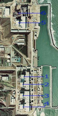
English: Fukushima I Nuclear Power Plant. Medium crop showing reactors labeled 1 to 5 and site for reactor 6. North is up.
日本語: 福島第一原子力発電所。 |
| Datum | |
| Quelle | http://w3land.mlit.go.jp/cgi-bin/WebGIS2/WC_AirPhoto.cgi?IT=p&DT=n&PFN=CTO-75-30&PCN=C29B&IDX=21 |
| Urheber | Ministry of Land, Infrastructure, Transport and Tourism |
| Andere Versionen |
|
| Kameraposition | | Dieses und weitere Bilder auf OpenStreetMap |
|---|
Lizenz

|
Der Urheberrechtsinhaber dieser Datei, Ministerium für Land, Infrastruktur, Verkehr und Tourismus, erlaubt es jedem, diese für jeden Zweck zu benutzen, vorausgesetzt, dass der Urheberrechtsinhaber ordnungsgemäß genannt wird. Weiterverbreitung, Abänderungen, kommerzielle Nutzung sowie jede andere Verwendung sind gestattet. |
Namensnennung:
Copyright © National Land Image Information (Color Aerial Photographs), Ministry of Land, Infrastructure, Transport and Tourism
|
 |
This image is copyrighted by the Ministry of Land, Infrastructure, Transport and Tourism of Japan. For terms of use, see the stipulation to use of National Land Information (in Japanese) and message from MLIT (in Japanese and English). When you display this image on an article, include the following phrase in the description: "Made based on National Land Image Information (Color Aerial Photographs), Ministry of Land, Infrastructure, Transport and Tourism".
|
Dateiversionen
Klicke auf einen Zeitpunkt, um diese Version zu laden.
| Version vom | Vorschaubild | Maße | Benutzer | Kommentar | |
|---|---|---|---|---|---|
| aktuell | 01:54, 16. Mär. 2011 | | 800 × 1.600 (248 KB) | 84user | =={{int:filedesc}}== {{Information |Description={{en|1=Fukushima I Nuclear Power Plant. Medium crop showing reactors labeled 1 to 5 and site for reactor 6. North is up.}} {{ja|1=[[:ja:福島第一原子力発電所| |
Dateiverwendung
Die folgenden 4 Seiten verwenden diese Datei:
Globale Dateiverwendung
Die nachfolgenden anderen Wikis verwenden diese Datei:
- Verwendung auf ar.wikipedia.org
- Verwendung auf ast.wikipedia.org
- Verwendung auf be-tarask.wikipedia.org
- Verwendung auf ca.wikipedia.org
- Verwendung auf cs.wikipedia.org
- Verwendung auf cv.wikipedia.org
- Verwendung auf de.wikinews.org
- Verwendung auf en.wikipedia.org
- Verwendung auf en.wikibooks.org
- Verwendung auf es.wikipedia.org
- Verwendung auf fi.wikipedia.org
- Verwendung auf fr.wikipedia.org
- Verwendung auf gl.wikipedia.org
- Verwendung auf he.wikipedia.org
- Verwendung auf hi.wikipedia.org
- Verwendung auf ja.wikipedia.org
- Verwendung auf ko.wikipedia.org
- Verwendung auf ko.wikinews.org
- Verwendung auf ms.wikipedia.org
- Verwendung auf nl.wikipedia.org
- Verwendung auf pl.wikipedia.org
- Verwendung auf pt.wikipedia.org
- Verwendung auf rm.wikipedia.org
- Verwendung auf ru.wikipedia.org
- Verwendung auf sq.wikinews.org
- Verwendung auf ta.wikipedia.org
- Verwendung auf th.wikipedia.org
- Verwendung auf zh.wikipedia.org