Datei:Chaparrastique.jpg
Es ist keine höhere Auflösung vorhanden.
Chaparrastique.jpg (640 × 432 Pixel, Dateigröße: 77 KB, MIME-Typ: image/jpeg)
![]()
Diese Datei und die Informationen unter dem roten Trennstrich werden aus dem zentralen Medienarchiv Wikimedia Commons eingebunden.
![]()
| Beschreibung |
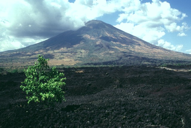
English: This sparsely vegetated basaltic lava flow was erupted from a fissure vent on the lower SE flank of San Miguel in 1819. The flow covers a broad 2.5-km-wide, 5-km-long area on the low-angle slopes below the volcano and reaches down to an elevation of less than 40 m above sea level. The principal coastal highway of El Salvador traverses the flow below the point of this photo, and the national railway crosses the flow closer to the vent. |
|||
| Datum | ||||
| Quelle | http://www.volcano.si.edu/world/volcano.cfm?vnum=1403-10=&volpage=photos&photo=076042 | |||
| Urheber | Lee Siebert (Smithsonian Institution) | |||
| Genehmigung (Weiternutzung dieser Datei) |
|
Dateiversionen
Klicke auf einen Zeitpunkt, um diese Version zu laden.
| Version vom | Vorschaubild | Maße | Benutzer | Kommentar | |
|---|---|---|---|---|---|
| aktuell | 23:37, 23. Jul. 2010 | | 640 × 432 (77 KB) | Michael Metzger | {{Information |Description={{en|1=This sparsely vegetated basaltic lava flow was erupted from a fissure vent on the lower SE flank of San Miguel in 1819. The flow covers a broad 2.5-km-wide, 5-km-long area on the low-angle slopes below the volcano and rea |
Dateiverwendung
Die folgende Seite verwendet diese Datei:
Globale Dateiverwendung
Die nachfolgenden anderen Wikis verwenden diese Datei:
- Verwendung auf az.wikipedia.org
- Verwendung auf be.wikipedia.org
- Verwendung auf ca.wikipedia.org
- Verwendung auf fa.wikipedia.org
- Verwendung auf fr.wikipedia.org
- Verwendung auf hy.wikipedia.org
- Verwendung auf ru.wikipedia.org
- Verwendung auf simple.wikipedia.org
- Verwendung auf uk.wikipedia.org